Area Overview for CT17 9SH
Photos of CT17 9SH

Area Information
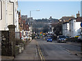
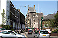
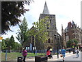
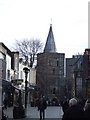
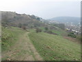
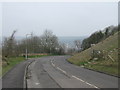
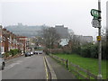
CT17 9SH is a small residential postcode in Dover, Kent, a historic port town on the south coast of England. With a population of 1,641 spread across just 1.5 hectares, this area is densely populated, reflecting Dover’s long-standing role as a key coastal settlement. The compact size means residents live in close proximity to the town’s amenities, including its famous white cliffs, historic landmarks, and strategic position on the Dover Strait. Daily life here is shaped by the town’s maritime heritage, with easy access to ferries, rail, and the nearby Dover Castle. The area is home to a mix of long-term residents and those drawn to Dover’s cultural and economic opportunities. While the postcode is small, it connects to a broader network of services, from independent schools to retail hubs, making it a practical choice for those seeking a balance between coastal living and urban convenience. The high population density underscores the need for efficient transport links, which are well-served by multiple rail stations and ferry terminals.
- Area Type
- Postcode
- Area Size
- 1.5 hectares
- Population
- 1641
- Population Density
- 112760 people/km²
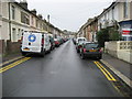
The property market in CT17 9SH is characterised by a low home ownership rate of 33%, suggesting that the area is more rental-focused than owner-occupied. Despite this, the predominant accommodation type is houses, which is atypical for a small, densely populated postcode. This mix may indicate a limited supply of larger homes, possibly attracting families or individuals seeking more space within a compact area. The small size of the postcode means the housing stock is likely concentrated in a few clusters, with limited scope for expansion. Buyers should consider the proximity to Dover’s amenities, including schools and transport links, which may offset the challenges of a smaller market. The high population density also means properties are in close proximity to one another, which could be a consideration for those prioritising privacy.
House Prices in CT17 9SH
No properties found in this postcode.
Energy Efficiency in CT17 9SH
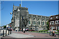
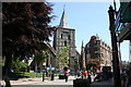
Living in CT17 9SH offers access to a range of amenities within practical reach. Retail options include major supermarkets like Asda Dover, Farmfoods Dover, and Morrisons Dover, providing convenience for daily shopping. The area’s proximity to Dover’s historic centre means residents can enjoy the town’s cultural attractions, including St Mary the Virgin Church and Dover Castle. The compact postcode ensures that essential services are nearby, though the limited space means community spaces are likely shared with other areas. The mix of rail, ferry, and metro transport options supports an active lifestyle, with opportunities for commuting, leisure travel, or exploring the nearby countryside. The area’s small size fosters a sense of closeness to local amenities, though it may lack large-scale recreational facilities.
Amenities
Schools
Near CT17 9SH are two independent schools: Dover College and Dover College International Study Centre. Both are private institutions, offering education from primary to secondary levels. The presence of independent schools suggests that the area may attract families seeking alternative educational options, though the data does not include Ofsted ratings or academic performance metrics. These schools cater to a range of needs, from traditional education to international curricula, reflecting Dover’s role as a cosmopolitan port town. However, the absence of state schools in the data means families relying on public education may need to look beyond the immediate area. The mix of independent options could be a draw for those prioritising specific educational philosophies or language programs.
| Rank | School | Type | Entry gender | Ages |
|---|
Explore more schools in this area
Go to Schools tabDemographics
CT17 9SH has a median age of 47, with the majority of residents falling into the 30–64 age range. This suggests a mature, stable community with a focus on established households rather than young families. Home ownership is relatively low at 33%, indicating that a significant portion of the population rents their homes. The predominant accommodation type is houses, which is unusual for a densely populated area, suggesting a mix of larger properties and possibly some older, family-oriented homes. The predominant ethnic group is White, with no specific data provided on other groups. The high population density of 112,760 people per square kilometre implies a compact, possibly multi-generational living environment. While the data does not specify deprivation levels, the combination of low home ownership and high density could indicate a mix of economic profiles, with some residents potentially relying on rental income or part-time work.
Household Size
Accommodation Type
Tenure
Ethnic Group
Religion
Household Composition
Age
Household Deprivation
NS-SEC
Explore more demographic insights in this area
Go to Demographics tabPlanning
Planning Constraints
- Flood RiskPremium
- Ramsar Wetland SitesPremium
- Area of Outstanding Natural BeautyPremium
- Protected Nature ReservePremium
- Protected WoodlandPremium
- Crime RiskPremium