Area Overview for CT16 1ST
Photos of CT16 1ST


Area Information
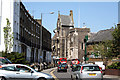
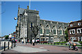
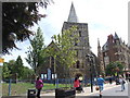
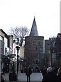
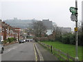
Living in CT16 1ST means inhabiting a small, densely populated residential cluster in the heart of Dover, Kent. The area covers just 303 square metres, housing 1,365 people in a space where the population density reaches 4.5 million per square kilometre. This compact postcode is part of Dover’s historic port town, strategically positioned on the Dover Strait, a location that has shaped its identity for centuries. Daily life here is defined by proximity to key amenities, including five retail outlets, multiple rail stations, and ferry terminals that connect the area to mainland Europe. The community is predominantly composed of adults aged 30–64, with a median age of 47, reflecting a mature demographic. While the area’s small size limits expansion, its density fosters a tightly knit environment. Residents benefit from proximity to Dover’s landmarks, such as St Mary the Virgin Church and Dover Castle, which anchor the area’s historical and cultural fabric. However, the high population density and limited housing stock mean that CT16 1ST is more a place of convenience than spacious living.
- Area Type
- Postcode
- Area Size
- 303 m²
- Population
- 1365
- Population Density
- 4503242 people/km²
The property market in CT16 1ST is characterised by a low home ownership rate of 31%, indicating that the area is more rental-focused than owner-occupied. The predominant accommodation type is flats, which aligns with the small, densely populated nature of the postcode. This suggests that housing stock is limited to smaller, multi-unit properties, likely concentrated in older buildings or purpose-built developments. For buyers seeking larger homes or detached properties, the area offers little scope, with the immediate surroundings likely to be similarly constrained by space. The high population density and compact size of CT16 1ST mean that property choices are limited to flats or shared spaces, making it an unattractive option for those prioritising home ownership or family-sized living. However, the proximity to Dover’s amenities and transport links may offset these limitations for those prioritising convenience over property size.
House Prices in CT16 1ST
No properties found in this postcode.
Energy Efficiency in CT16 1ST
Residents of CT16 1ST have access to a range of amenities within walking or short driving distance. The area includes five retail outlets, such as M&S St James Retail, Iceland St James Retail Park, and Asda Dover, providing everyday shopping convenience. Nearby rail stations and ferry terminals offer easy access to both domestic and international travel, while the proximity to Dover’s historic sites, including St Mary the Virgin Church and Dover Castle, adds cultural value. The area’s compact size means that essential services are clustered closely, reducing the need for long commutes. However, the lack of green spaces or parks within the postcode itself may require residents to travel slightly further for leisure or outdoor activities. The mix of retail, transport, and historical attractions creates a lifestyle that balances practicality with access to heritage, though the absence of recreational spaces could be a drawback for some.
Amenities
Schools
The nearest school to CT16 1ST is Castlemount Secondary School, a secondary institution serving the area. No data is provided on its Ofsted rating, but its presence indicates that families in the postcode have access to secondary education. The absence of primary schools in the immediate vicinity suggests that younger children may need to travel to nearby areas for schooling, potentially increasing commuting time for parents. The single secondary school serves a significant portion of the local population, which may impact student numbers and resources. For families prioritising a range of educational options, the lack of primary schools and limited information on secondary school performance could be a concern. However, the proximity to Dover’s broader infrastructure may mitigate these challenges for some residents.
| Rank | School | Type | Entry gender | Ages |
|---|
Explore more schools in this area
Go to Schools tabDemographics
CT16 1ST’s population of 1,365 is dominated by adults aged 30–64, with a median age of 47. This suggests a community that is largely settled, with fewer young families or retirees compared to other areas. Home ownership in the postcode is low at 31%, indicating that the majority of residents are likely to be renters, possibly due to the area’s limited housing stock and high demand. The accommodation type is predominantly flats, reflecting a housing market that prioritises compact living over detached properties. The predominant ethnic group is White, with no specific data on other demographics. The high population density—4.5 million per square kilometre—raises questions about living conditions, though this is typical for urban or historic town centres. For residents, this density means proximity to amenities but also potential challenges in finding larger homes or private outdoor space. The demographic profile suggests a community that may value convenience and accessibility over expansive living quarters.
Household Size
Accommodation Type
Tenure
Ethnic Group
Religion
Household Composition
Age
Household Deprivation
NS-SEC
Explore more demographic insights in this area
Go to Demographics tabPlanning
Planning Constraints
- Flood RiskPremium
- Ramsar Wetland SitesPremium
- Area of Outstanding Natural BeautyPremium
- Protected Nature ReservePremium
- Protected WoodlandPremium
- Crime RiskPremium