Area Overview for CT14 9YX
Photos of CT14 9YX


Area Information
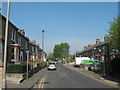
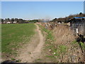
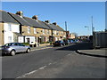
Living in CT14 9YX means being part of Deal, a historic market town on Kent’s coast, where the past meets the present. With a population of 1,407, this small postcode area captures the essence of a coastal community shaped by centuries of maritime history. Deal’s three distinct parts—Lower, Middle, and Upper—form a compact, walkable cluster of homes and heritage. As a former Cinque Ports port and a bustling 13th-century trading hub, the town retains its maritime legacy, now balanced with modern amenities. Residents benefit from proximity to Canterbury (18 miles) and London (72 miles), offering easy access to cultural and economic centres. The area’s charm lies in its blend of historic architecture, like Deal Castle and St. George’s Church, with contemporary comforts. Daily life here is defined by a relaxed coastal rhythm, with easy access to the sea, rail links, and a tight-knit community. For those seeking a place where history and practicality coexist, CT14 9YX offers a distinctive slice of Kentish living.
- Area Type
- Postcode
- Area Size
- Not available
- Population
- 1407
- Population Density
- 5902 people/km²
The property market in CT14 9YX is characterised by a strong presence of owner-occupied homes, with 63% of residents owning their properties. The accommodation type is predominantly houses, which is unusual for a small postcode area but reflects Deal’s historical development as a market town with larger residential plots. This suggests a market skewed towards family homes rather than apartments or flats, making it appealing to those seeking space and privacy. The limited size of the area means the housing stock is finite, potentially creating competition among buyers. However, the high broadband score (98/100) and decent mobile coverage (83/100) enhance the area’s appeal for remote workers. For buyers, the focus on houses implies a need to consider proximity to the town’s amenities and transport links, as the small postcode area may not offer extensive variety in property types.
House Prices in CT14 9YX
No properties found in this postcode.
Energy Efficiency in CT14 9YX
Life in CT14 9YX is enriched by nearby amenities, including five retail outlets such as Budgens, Sainsburys, and Co-op, ensuring everyday shopping needs are met. The area’s proximity to Deal’s historic core means residents can explore landmarks like Deal Castle, St. Leonard’s Church, and St. George’s Church, which hosts concerts and events. The town’s status as a seaside resort offers leisure opportunities, from coastal walks to local dining. Rail stations like Walmer and Sandwich provide access to broader networks, while the Metro’s Eythorne Station connects to more distant destinations. The blend of retail, heritage, and transport infrastructure creates a convenient, characterful lifestyle, balancing coastal charm with practicality for daily living.
Amenities
Schools
| Rank | School | Type | Entry gender | Ages |
|---|
Explore more schools in this area
Go to Schools tabDemographics
The community in CT14 9YX is predominantly composed of adults aged 30–64, reflecting a median age of 47. This suggests a stable, mature population with established careers and family lives. Home ownership rates stand at 63%, with houses being the primary accommodation type, indicating a focus on private, long-term residency rather than rental properties. The predominant ethnic group is White, which aligns with broader trends in the region. The absence of specific data on deprivation or diversity means the area’s social fabric remains largely unexamined in public records. However, the age profile and home ownership figures imply a community prioritising security and continuity. With no mention of high deprivation levels, it is reasonable to infer that quality of life here is supported by steady employment and housing stability, typical of a small coastal town with historical economic foundations.
Household Size
Accommodation Type
Tenure
Ethnic Group
Religion
Household Composition
Age
Household Deprivation
NS-SEC
Explore more demographic insights in this area
Go to Demographics tabPlanning
Planning Constraints
- Flood RiskPremium
- Ramsar Wetland SitesPremium
- Area of Outstanding Natural BeautyPremium
- Protected Nature ReservePremium
- Protected WoodlandPremium