Area Overview for CT14 9GH
Photos of CT14 9GH


Area Information
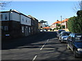
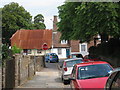
Living in CT14 9GH means residing in a small, tightly knit residential cluster in Deal, Kent. With a population of 1,483, the area reflects the character of a historic market town, where the past meets modern convenience. Deal’s coastal location, just 18 miles from Canterbury and 72 from London, positions it as a gateway to the South East. The town’s three distinct parts—Lower, Middle, and Upper Deal—form a compact, walkable community with a strong sense of local identity. Residents here are predominantly adults aged 30–64, with 85% owning their homes. The area’s housing stock is largely composed of houses, reflecting a stable, long-term demographic. Daily life is shaped by proximity to retail, transport, and historical landmarks, such as Deal Castle, built by Henry VIII. The postcode’s small size means amenities are within practical reach, while its coastal setting offers both scenic beauty and a connection to Deal’s heritage as a Cinque Port. For buyers, CT14 9GH represents a blend of tradition and accessibility, with low crime rates and excellent digital connectivity.
- Area Type
- Postcode
- Area Size
- Not available
- Population
- Not available
- Population Density
- Not available
The property market in CT14 9GH is defined by high home ownership (85%) and a focus on houses rather than flats or apartments. This reflects a residential area where long-term occupancy and family living are the norm. The small size of the postcode means the housing stock is limited, with no indication of new developments or rental properties. Buyers should expect a competitive market for existing homes, particularly given the area’s low crime rates and proximity to amenities. The predominance of houses suggests properties are likely to be larger, with gardens, appealing to those seeking traditional, spacious living. However, the small footprint of the postcode means opportunities for purchase are constrained, and buyers may need to look beyond immediate surroundings for more options. The market is likely stable, with demand driven by the area’s coastal location and historical charm.
House Prices in CT14 9GH
No properties found in this postcode.
Energy Efficiency in CT14 9GH
The lifestyle in CT14 9GH is shaped by its proximity to essential amenities and historical charm. Residents have access to five retail outlets, including Co-op Deal, Co-op Mill, and Tesco Deal, ensuring everyday shopping needs are met. The area’s transport links to multiple railway stations, including Deal and Walmer, provide easy access to broader networks, while Eythorne metro station adds flexibility. Though the data does not mention parks or leisure facilities, the coastal setting of Deal implies opportunities for outdoor activities. The presence of Deal Castle and three historic churches, such as St. George’s Church, adds cultural and architectural interest. The community’s compact size means amenities are within walking distance, fostering a convenient, connected lifestyle.
Amenities
Schools
The nearest school to CT14 9GH is Brewood Secondary School, a special school with a good Ofsted rating. This indicates the area is well-served for students with specific educational needs, though no mainstream primary or secondary schools are listed. The presence of a special school suggests families with children requiring tailored support may find the area suitable, but those seeking a broader range of educational options may need to look further afield. The absence of other schools in the data means the area’s school provision is limited to this single institution. Parents should consider proximity to other schools in Deal, such as those in the wider town, as CT14 9GH itself does not host additional educational facilities.
| Rank | School | Type | Entry gender | Ages |
|---|---|---|---|---|
| 1 | Brewood Secondary School | special | N/A | N/A |
Explore more schools in this area
Go to Schools tabDemographics
CT14 9GH’s population of 1,483 is dominated by adults aged 30–64, with a median age of 47. This suggests a mature, established community, likely with strong family ties and long-term residency. Home ownership is high at 85%, indicating a stable, owner-occupied area rather than a rental hotspot. The accommodation type is primarily houses, which aligns with the area’s residential character and may appeal to those seeking space and privacy. The predominant ethnic group is White, though no specific diversity metrics are provided. The absence of data on deprivation or socioeconomic breakdown means the area’s quality of life is inferred from its safety, connectivity, and amenities. The demographic profile suggests a community focused on stability, with residents likely prioritising proximity to schools, transport, and coastal lifestyle benefits.
Household Size
Accommodation Type
Tenure
Ethnic Group
Religion
Household Composition
Age
Household Deprivation
NS-SEC
Explore more demographic insights in this area
Go to Demographics tabPlanning
Planning Constraints
- Flood RiskPremium
- Ramsar Wetland SitesPremium
- Area of Outstanding Natural BeautyPremium
- Protected Nature ReservePremium
- Protected WoodlandPremium
- Crime RiskPremium