Area Overview for CT14 9BD
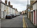
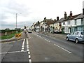
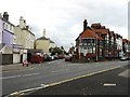
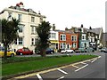
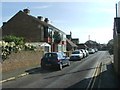
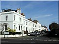
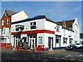
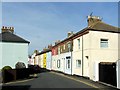
Photos of CT14 9BD


Area Information
CT14 9BD is a compact residential postcode area in Kent, covering just 2.3 hectares and home to 1372 people. Its high population density of 59,911 people per square kilometre reflects its small, tightly knit character. Nestled on the Kent coast, the area is part of Deal, an ancient market town with a rich history as a Cinque Port and bustling 13th-century port. Modern residents live in three distinct parts of Deal—Lower, Middle, and Upper—each arranged along narrow streets parallel to the beach. The town’s coastal location offers proximity to both Canterbury (18 miles west) and London (72 miles west), though its charm lies in its historic architecture, including Deal Castle built by Henry VIII. Daily life here is shaped by its small-scale community, with local amenities, schools, and transport links catering to a population skewed toward adults aged 30–64. The area’s blend of historical legacy and practical modernity makes it appealing for those seeking a quieter, rooted lifestyle near coastal and cultural hubs.
- Area Type
- Postcode
- Area Size
- 2.3 hectares
- Population
- 1372
- Population Density
- 4400 people/km²
CT14 9BD is a small, owner-occupied area where 53% of homes are owned by residents, compared to 47% rented. The primary accommodation type is houses, which aligns with the area’s historic and residential character. Given the postcode’s tiny size—just 2.3 hectares—the housing stock is limited, likely comprising a mix of older properties and newer builds. For buyers, this means competition for available homes, particularly in a market where owner-occupation is the norm. The area’s proximity to Deal’s amenities and coastal location may attract families seeking a quieter alternative to larger towns. However, the small footprint of CT14 9BD means buyers should consider nearby postcodes for broader options, as the immediate area offers limited property diversity.
House Prices in CT14 9BD
No properties found in this postcode.
Energy Efficiency in CT14 9BD
Residents of CT14 9BD have access to essential amenities within walking or short driving distance. Retail options include Co-op Deal, Budgens Deal, and Co-op Mill, providing grocery and daily needs. The area’s rail network connects to four stations, including Deal and Walmer, offering frequent services to Canterbury and London. While the data does not list specific parks or leisure facilities, Deal’s historic sites—such as Deal Castle and St. George’s Church—are nearby, offering cultural and recreational value. The small postcode area’s compact nature means daily life revolves around local shops, schools, and transport hubs, creating a convenient but limited range of choices. For those prioritising proximity to services over expansive leisure options, CT14 9BD’s amenities are practical, though not extensive.
Amenities
Schools
Residents of CT14 9BD have access to a range of schools, including South Deal Primary School and Castle Community College, both designated as primary institutions. The Goodwin Academy appears twice in the data, listed as an academy with an Ofsted rating of ‘good’. This mix of primary and academy schools provides families with options for both early education and secondary schooling. The presence of multiple schools suggests a focus on local education infrastructure, though no specific performance metrics are provided beyond the Ofsted rating for The Goodwin Academy. Families seeking a variety of educational pathways may find the cluster of schools here advantageous, though the exact catchment areas and admission policies are not detailed in the data.
| Rank | School | Type | Entry gender | Ages |
|---|
Explore more schools in this area
Go to Schools tabDemographics
The population of CT14 9BD is predominantly adults aged 30–64, with a median age of 47. This suggests a mature, settled community, likely with strong family ties and long-term residency. Home ownership stands at 53%, with houses being the primary accommodation type. The predominant ethnic group is White, reflecting the area’s demographic profile. The high population density—59,911 people per square kilometre—indicates a compact, possibly multi-generational living environment. While no specific deprivation data is provided, the high home ownership rate and age distribution suggest a stable, low-turnover community. The absence of data on diversity metrics means the area’s inclusivity cannot be assessed, but the demographic profile points to a traditional, homogenous population.
Household Size
Accommodation Type
Tenure
Ethnic Group
Religion
Household Composition
Age
Household Deprivation
NS-SEC
Explore more demographic insights in this area
Go to Demographics tabPlanning
Planning Constraints
- Flood RiskPremium
- Ramsar Wetland SitesPremium
- Area of Outstanding Natural BeautyPremium
- Protected Nature ReservePremium
- Protected WoodlandPremium