Area Overview for CT14 7PG
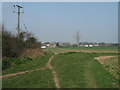
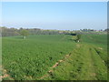
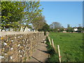
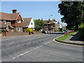
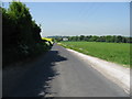
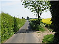
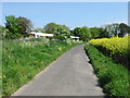
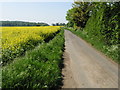
Photos of CT14 7PG


Area Information
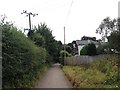
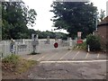
Living in CT14 7PG means inhabiting a small, rural village in Kent with a population of 1,735 spread across 12 hectares. This postcode area, known as Ripple, retains its historical character as a Saxon village with a church, pub, and a network of local amenities. The village is defined by its quiet, traditional feel, with homes primarily in the form of detached or semi-detached houses. Its proximity to Deal railway station—2.5 miles northeast—offers easy access to regional transport links, while nearby Dover’s ferry terminals provide coastal connectivity. Despite its small size, the area has a stable community, with 78% of residents owning their homes. The village’s charm lies in its heritage, including the Grade II listed Church of St Mary the Virgin and the village pub, The Plough, though the latter is set to close in 2024. For those seeking a peaceful, low-density environment with historical roots, CT14 7PG offers a distinct blend of rural tranquillity and accessible infrastructure.
- Area Type
- Postcode
- Area Size
- 12.0 hectares
- Population
- 1735
- Population Density
- 104 people/km²
The property market in CT14 7PG is characterised by high home ownership (78%) and a predominance of houses, reflecting a largely owner-occupied area. With a population of 1,735 spread over 12 hectares, the housing stock is limited, meaning buyers may need to consider nearby villages or towns for additional options. The focus on houses suggests a market catering to families and individuals seeking space and privacy, typical of rural or semi-rural settings. The small size of the area means property availability is constrained, and competition for homes may be higher than in larger towns. For buyers, this implies a need to act decisively, as the market is unlikely to see frequent new listings. The lack of flats or apartments also means that rental demand is likely lower, with most properties serving owner-occupiers rather than investors.
House Prices in CT14 7PG
No properties found in this postcode.
Energy Efficiency in CT14 7PG
Residents of CT14 7PG enjoy a lifestyle shaped by its small village character and nearby amenities. The area’s retail options include five shops, such as Tesco Deal and Co-op outlets, providing access to groceries and daily essentials. Transport links are practical, with five rail stations and a metro stop offering regional and local connectivity. The village itself retains a traditional feel, with landmarks like the Church of St Mary the Virgin and the village pub, The Plough, which, despite its planned closure, has historically been a social hub. Nearby Dover’s ferry terminals add to the area’s appeal for those seeking coastal access. While the village is small, its proximity to Deal and Dover ensures residents can access larger towns for leisure, dining, and services. The balance of rural tranquillity and accessible infrastructure makes CT14 7PG suitable for those valuing a quiet lifestyle without complete isolation.
Amenities
Schools
Residents of CT14 7PG have access to a range of schools, including primary and special needs institutions. The Ripple School is a primary school, while St Margaret’s-at-Cliffe Primary School holds a ‘good’ Ofsted rating, indicating strong educational standards. Ripplevale School and Portal House School both cater to special educational needs, with Ripplevale also rated ‘good’ by Ofsted. This mix of school types ensures families have options for both mainstream and specialist education. The presence of two ‘good’-rated primary schools suggests a solid foundation for early education, while the special schools address specific needs within the community. For parents, this diversity means flexibility in choosing schools that align with their children’s requirements, though the limited number of schools may necessitate commuting to nearby areas for secondary education.
| Rank | School | Type | Entry gender | Ages |
|---|---|---|---|---|
| 1 | The Ripple School | primary | N/A | N/A |
| 2 | St Margaret's-at-Cliffe Primary School | primary | N/A | N/A |
| 3 | Ripplevale School | special | N/A | N/A |
| 4 | Portal House School | special | N/A | N/A |
Explore more schools in this area
Go to Schools tabDemographics
The population of CT14 7PG is 1,735, with a density of 104 people per square kilometre. The median age is 47, and the majority of residents fall within the 30-64 age range, indicating a mature, stable community. Home ownership is high at 78%, with the predominant accommodation type being houses, reflecting a suburban or rural housing profile. The predominant ethnic group is White, with no data provided on other demographics. This suggests a homogenous population, which may influence local culture and social dynamics. The age profile implies a mix of established families and retirees, with fewer young children compared to other areas. The relatively low population density and high home ownership rate indicate a community prioritising long-term residency over transient living. For buyers, this suggests a market with limited turnover, where properties are likely to remain in private hands for extended periods.
Household Size
Accommodation Type
Tenure
Ethnic Group
Religion
Household Composition
Age
Household Deprivation
NS-SEC
Explore more demographic insights in this area
Go to Demographics tabPlanning
Planning Constraints
- Flood RiskPremium
- Ramsar Wetland SitesPremium
- Area of Outstanding Natural BeautyPremium
- Protected Nature ReservePremium
- Protected WoodlandPremium
- Crime RiskPremium