Area Overview for CT12 6PN
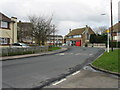
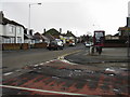
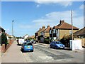
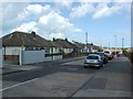
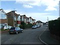
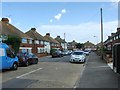
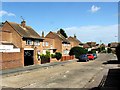
Photos of CT12 6PN


Area Information
CT12 6PN represents a specific postcode cluster within the town of Ramsgate, situated on the historic Isle of Thanet in Kent. This residential area encompasses a small footprint of just 651 square metres, serving a population of 1,706 residents. The location draws on Ramsgate's deep history as a coastal resort, featuring the only Royal Harbour on the mainland of Britain and significant landmarks like the Shrine of St Augustine. Living in CT12 6PN means accessing a community with tangible historical weight, from the 18th-century construction of the Royal Harbour to the Regency architecture found nearby on East Cliff. The area functions as a quiet residential pocket while remaining close to major transport hubs and the seafront. You are part of a small, defined community where the scale of the neighbourhood ensures a distinct sense of place. This postcode offers access to the sea and a town rich in heritage, combining the serenity of a specific residential cluster with the amenities of a well-established sea resort. The character of CT12 6PN is shaped by its proximity to the Ramsgate Railway Station and the broader historic landscape that defines the town's identity.
- Area Type
- Postcode
- Area Size
- 651 m²
- Population
- Not available
- Population Density
- Not available
The property market within and around CT12 6PN is characterised by a low level of home ownership, sitting at just 32%. This figure suggests that the area functions significantly as a rental market rather than a traditional owner-occupied district. The predominant accommodation type consists of houses, which contrasts with the prevalence of flats in many new-build coastal developments. For buyers looking at this specific postcode cluster, the market may require more patience compared to areas with higher existing ownership rates. The small area size of 651 square metres limits the volume of available properties, making the few houses present highly competitive. You might find that standalone homes in this location carry a premium or may be less available than rented units. The 1,706-resident population in this compact zone creates a tight-knit market where properties move specifically to meet the needs of the surrounding rentals. While the low ownership rate might signal a high demand for professional landlords, it also means owners who do purchase are likely to be long-term residents or investors targeting the mature demographic.
House Prices in CT12 6PN
No properties found in this postcode.
Energy Efficiency in CT12 6PN
Your daily life in CT12 6PN is supported by a range of amenities located within practical reach. Retail options include Morrisons Daily, Spar, and Tesco Ramsgate, ensuring you have access to supermarkets and daily necessities without a long journey. For travel and leisure, Ramsgate Railway Station and Dumpton Park Railway Station provide quick rail connections, while Broadstairs Railway Station offers alternative routes nearby. The Ramsgate Ferry Terminal enables direct sea travel, and Kent International Airport is available for flights. Living in CT12 6PN places you close to these essential services, reducing the time spent commuting for groceries or travel. The area's lifestyle is anchored by the history of Ramsgate, meaning you can walk to historic sites like the Royal Harbour or the Church of St Laurence. With five notable retail outlets and five railway stations on your horizon, the convenience of CT12 6PN is balanced against the rich cultural heritage of the town. You enjoy the ability to access modern shopping and transport while remaining steps away from a town defined by its 18th-century heritage and coastal setting.
Amenities
Schools
| Rank | School | Type | Entry gender | Ages |
|---|
Explore more schools in this area
Go to Schools tabDemographics
The community in CT12 6PN reflects a mature demographic profile typical of established coastal resorts. The median age for residents is 47 years, with adults aged between 30 and 64 years forming the most common age range. This indicates a neighbourhood settled by families that have stayed long-term or professionals seeking stability. Home ownership stands at 32%, meaning the majority of the 1,706 residents are tenants rather than owners. The accommodation type is predominantly houses, suggesting a preference for detached or semi-detached living over flats. The predominant ethnic group is White, aligning with the broader demographic makeup of the Thanet region. With an area size of 651 square metres and a population density that supports this specific housing model, the local feel is likely quieter than larger urban centres. This age distribution suggests a need for family-friendly amenities and reliable services, as the core demographic relies heavily on local infrastructure for daily needs. The housing stock is not characterised by high-rise living but by a mix of houses suitable for this older, stable population.
Household Size
Accommodation Type
Tenure
Ethnic Group
Religion
Household Composition
Age
Household Deprivation
NS-SEC
Explore more demographic insights in this area
Go to Demographics tabPlanning
Planning Constraints
- Flood RiskPremium
- Ramsar Wetland SitesPremium
- Area of Outstanding Natural BeautyPremium
- Protected Nature ReservePremium
- Protected WoodlandPremium
- Crime RiskPremium