Area Overview for CT1 3DN
Photos of CT1 3DN

Area Information
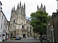
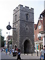
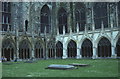
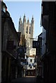
CT1 3DN lies within the historic city of Canterbury, a UNESCO World Heritage Site in Kent. This small postcode area covers 2,439 m² and is home to 2,499 residents, making it one of the most densely populated regions in England, with over 1 million people per square kilometre. The area is part of Barton Ward, a historic electoral district encompassing medieval precincts and sites like Barton Hall, linked to the Culpeper family. Daily life here is shaped by its proximity to Canterbury’s cultural and historical landmarks, including Jesus Hospital. The community is young, with a median age of 22, and reflects the city’s character as a hub of education and heritage. Residents benefit from Canterbury’s transport links and retail offerings, while the area’s compact size means amenities are within easy reach. Living in CT1 3DN offers a blend of urban convenience and historical significance, though the high population density may influence the pace of life.
- Area Type
- Postcode
- Area Size
- 2439 m²
- Population
- Not available
- Population Density
- Not available
CT1 3DN’s property market is characterised by a 47% home ownership rate, with houses forming the predominant accommodation type. This suggests a mix of owner-occupied and rental properties, though the exact proportion of rental homes is not specified. The small area size and high population density mean housing stock is likely limited, with competition for properties in this historic postcode. Buyers should consider that the area’s compact nature may limit expansion, and properties may cater to young professionals or students. The presence of Canterbury’s infrastructure, including transport links and retail, could enhance property value, though the high population density may affect living space per household.
House Prices in CT1 3DN
No properties found in this postcode.
Energy Efficiency in CT1 3DN
Residents of CT1 3DN have access to a range of amenities within practical reach. Retail options include major chains such as Tesco, Waitrose, and M&S Canterbury, providing everyday shopping convenience. The area’s rail network, with stations at Canterbury East, West, and Bekesbourne, facilitates easy commuting to surrounding towns and cities. While the data does not mention parks or leisure facilities, the proximity to Canterbury’s historic sites and the city’s broader infrastructure likely offers cultural and recreational opportunities. The compact nature of the postcode means amenities are closely clustered, supporting a lifestyle that balances urban convenience with historical context.
Amenities
Schools
The nearest school to CT1 3DN is Canterbury College, a sixth-form institution offering post-16 education. No primary or secondary schools are listed in the data, which may impact families requiring early education. The absence of schools at other levels suggests residents may need to travel to nearby areas for primary or secondary schooling. For those prioritising sixth-form education, Canterbury College provides access to higher-level studies, aligning with the area’s youthful demographic. Families should assess the need for additional schooling options beyond CT1 3DN’s immediate reach.
| Rank | School | Type | Entry gender | Ages |
|---|---|---|---|---|
| 1 | Canterbury College | sixth-form | N/A | N/A |
Explore more schools in this area
Go to Schools tabDemographics
The population of CT1 3DN is predominantly young adults, with 15–29-year-olds making up the most common age group. The median age of 22 suggests a community focused on early career development and education. Home ownership stands at 47%, with houses being the primary accommodation type. The predominant ethnic group is White, reflecting Canterbury’s demographic profile. This data indicates a relatively stable, owner-occupied population, though the lower home ownership rate implies a significant proportion of residents may rent. The area’s youthful demographic may influence local services and amenities, with demand skewed towards housing that suits transient or student populations.
Household Size
Accommodation Type
Tenure
Ethnic Group
Religion
Household Composition
Age
Household Deprivation
NS-SEC
Explore more demographic insights in this area
Go to Demographics tabPlanning
Planning Constraints
- Flood RiskPremium
- Ramsar Wetland SitesPremium
- Area of Outstanding Natural BeautyPremium
- Protected Nature ReservePremium
- Protected WoodlandPremium
- Crime RiskPremium