Area Overview for CT1 1LJ
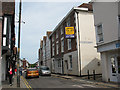
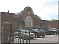
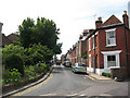
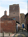
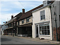
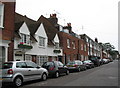
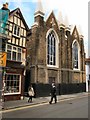
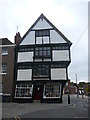
Photos of CT1 1LJ
Area Information
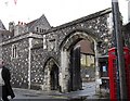
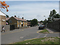
Living in CT1 1LJ, a small residential postcode cluster in Canterbury, Kent, means being part of a densely populated area with a compact footprint of 2,443 m². The population of 1,853 residents is concentrated in a historically significant part of the city, historically linked to the medieval North Gate. This area is defined by its proximity to Canterbury’s historic core, with landmarks such as the former North Gate and St Mary Northgate Church, now owned by King’s School. Daily life here is shaped by its proximity to the city’s medieval walls and modern amenities. The community is young, with a median age of 22, and the most common age group is adults aged 30–64. While the area is small, it offers access to Canterbury’s cultural and commercial hubs, including nearby railway stations and retail outlets. Its compact size means residents are close to key services, though the high population density reflects its role as a residential node within the city’s historic framework.
- Area Type
- Postcode
- Area Size
- 2443 m²
- Population
- Not available
- Population Density
- Not available
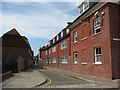
The property market in CT1 1LJ is characterised by a low home ownership rate of 29%, suggesting that the area is more rental-focused than owner-occupied. The predominant accommodation type is flats, which is typical for small, densely populated urban areas. This reflects the constraints of the area’s size and historical layout, which may limit the availability of larger homes or detached properties. For buyers, this means the housing stock is likely to consist of smaller, shared spaces, with limited scope for expansion. The high population density further reinforces the likelihood of flats being the primary housing type. While the area’s compact nature may appeal to those seeking proximity to Canterbury’s amenities, buyers should consider the limited availability of private outdoor space and the potential for a competitive rental market.
House Prices in CT1 1LJ
No properties found in this postcode.
Energy Efficiency in CT1 1LJ
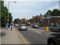
Residents of CT1 1LJ have access to a range of amenities within practical reach. The area includes five retail outlets, with notable stores such as Sainsburys Canterbury and M&S Canterbury, offering shopping convenience. The proximity to Canterbury’s historic and commercial districts means residents can easily access dining, leisure, and cultural activities in the city centre. While the area itself is small, its location near Canterbury’s medieval walls and modern amenities provides a blend of historical charm and contemporary convenience. The presence of rail stations and retail options supports a lifestyle that balances local needs with broader city access, making daily life practical and connected.
Amenities
Schools
Residents of CT1 1LJ have access to several primary schools within practical reach. These include Kingsmead Primary School, Diocesan and Payne Smith Church of England Primary School, St Thomas’ Catholic Primary School (rated ‘good’ by Ofsted), and St Johns Church of England Primary School (also rated ‘good’). The presence of multiple primary schools, including two with ‘good’ Ofsted ratings, suggests a range of educational options for families. The mix of state and church-affiliated schools may cater to different preferences, from secular to faith-based education. However, the absence of secondary schools in the immediate area means families may need to consider commuting to nearby districts for higher education. The availability of quality primary schools is a key consideration for families prioritising early education in the area.
| Rank | School | Type | Entry gender | Ages |
|---|---|---|---|---|
| 1 | Kingsmead Primary School | primary | N/A | N/A |
| 2 | Diocesan and Payne Smith Church of England Primary School | primary | N/A | N/A |
| 3 | St Thomas' Catholic Primary School, Canterbury | primary | N/A | N/A |
| 4 | St Johns Church of England Primary School | primary | N/A | N/A |
Explore more schools in this area
Go to Schools tabDemographics
The community in CT1 1LJ has a median age of 22, indicating a youthful demographic, with the most common age group being adults aged 30–64. Home ownership is low, at 29%, suggesting a higher proportion of renters. The accommodation type is predominantly flats, which is typical for urban areas with limited space. The predominant ethnic group is White, reflecting Canterbury’s broader demographic profile. The high population density—758,411 people per km²—suggests a compact, possibly multi-generational living environment. This density may impact the availability of private outdoor space but aligns with the area’s role as a residential hub near Canterbury’s historic and commercial centres. The low home ownership rate may indicate a reliance on rental properties, which could influence the local property market and community dynamics.
Household Size
Accommodation Type
Tenure
Ethnic Group
Religion
Household Composition
Age
Household Deprivation
NS-SEC
Explore more demographic insights in this area
Go to Demographics tabPlanning
Planning Constraints
- Flood RiskPremium
- Ramsar Wetland SitesPremium
- Area of Outstanding Natural BeautyPremium
- Protected Nature ReservePremium
- Protected WoodlandPremium
- Crime RiskPremium