Area Overview for CT1 1GE
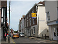
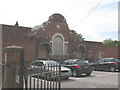
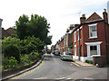
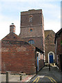
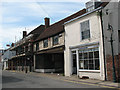
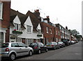
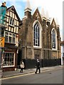
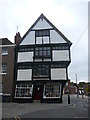
Photos of CT1 1GE
Area Information
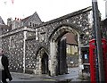
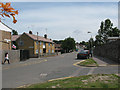
Living in CT1 1GE means being part of a small, tightly knit residential cluster in Canterbury, a historic city in Kent. With a population of 1,853, this postcode area is compact, centred around the Northgate Ward, which historically bordered Canterbury’s medieval walls. The area’s character is shaped by its proximity to landmarks like the former North Gate and St Mary Northgate Church, now owned by King’s School. Daily life here blends modern convenience with historical resonance. Residents benefit from nearby retail hubs, rail links, and a range of primary schools. The community is predominantly adults aged 30–64, with a median age of 22, reflecting a mix of young professionals and families. While the area lacks sprawling green spaces, its proximity to Canterbury’s cultural and administrative heart offers easy access to services, transport, and amenities. The small scale of the area means a close-knit feel, though buyers should consider the limited housing stock and the need to look beyond the immediate postcode for broader options.
- Area Type
- Postcode
- Area Size
- Not available
- Population
- Not available
- Population Density
- Not available
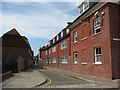
The property market in CT1 1GE is characterised by a low home ownership rate of 29%, indicating that the majority of housing stock is rented out. Flats dominate the accommodation type, which is typical for smaller, urban postcode areas. This suggests a focus on rental properties rather than owner-occupied homes, possibly due to the area’s compact size and limited land availability. Buyers looking at CT1 1GE should expect a constrained market, with fewer options compared to larger surrounding areas. The prevalence of flats may appeal to those seeking manageable, low-maintenance housing, but it also means competition for available properties. For those prioritising ownership, nearby areas or broader parts of Canterbury may offer more variety. The small scale of the postcode means that property prices and availability are likely influenced by broader Canterbury trends rather than local specifics.
House Prices in CT1 1GE
No properties found in this postcode.
Energy Efficiency in CT1 1GE
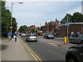
The lifestyle in CT1 1GE is shaped by its proximity to retail, dining, and community facilities. Nearby amenities include major supermarkets such as Sainsburys Canterbury, Farmfoods Canterbury, and Asda Canterbury, ensuring easy access to groceries and daily essentials. The area’s rail links to Canterbury West, East, and Sturry stations provide convenient travel options for shopping, work, or leisure. While the postcode itself is small, the surrounding Northgate Ward includes the Northgate Ward Community Centre, established in 1997, offering local gatherings and events. The historical and cultural heritage of Canterbury adds depth to the area, with landmarks like St Mary Northgate Church nearby. However, the lack of parks or green spaces within the postcode means residents may need to travel to adjacent areas for outdoor recreation. The mix of retail, transport, and community facilities supports a practical, urban lifestyle with a focus on accessibility.
Amenities
Schools
Residents of CT1 1GE have access to several primary schools, including Kingsmead Primary School and Diocesan and Payne Smith Church of England Primary School, both of which cater to younger children. Two schools—St Thomas’ Catholic Primary School, Canterbury, and St Johns Church of England Primary School—have been rated ‘good’ by Ofsted, offering families a choice of quality education. The mix of Church of England and Catholic schools reflects the area’s religious diversity and provides options for families with specific preferences. These schools are within practical reach, ensuring ease of access for parents and students. The presence of multiple primary schools in close proximity supports a family-friendly environment, though secondary education options would require looking beyond the immediate postcode. The overall availability of primary schools strengthens the area’s appeal for households with young children.
| Rank | School | Type | Entry gender | Ages |
|---|---|---|---|---|
| 1 | Kingsmead Primary School | primary | N/A | N/A |
| 2 | Diocesan and Payne Smith Church of England Primary School | primary | N/A | N/A |
| 3 | St Thomas' Catholic Primary School, Canterbury | primary | N/A | N/A |
| 4 | St Johns Church of England Primary School | primary | N/A | N/A |
Explore more schools in this area
Go to Schools tabDemographics
CT1 1GE has a median age of 22, but the most common age range among residents is 30–64 years, indicating a mature adult population. Home ownership is low at 29%, suggesting that the area is more rental-focused than owner-occupied. Flats are the predominant accommodation type, which aligns with the compact nature of the postcode. The predominant ethnic group is White, with no data provided on other demographics. This profile suggests a community of established residents, possibly including professionals and families, with limited younger or elderly populations. The low home ownership rate may reflect the area’s role as a secondary residence or rental market, rather than a primary home for long-term buyers. The absence of specific data on deprivation or diversity means the quality of life is inferred from the availability of services and amenities rather than socioeconomic metrics.
Household Size
Accommodation Type
Tenure
Ethnic Group
Religion
Household Composition
Age
Household Deprivation
NS-SEC
Explore more demographic insights in this area
Go to Demographics tabPlanning
Planning Constraints
- Flood RiskPremium
- Ramsar Wetland SitesPremium
- Area of Outstanding Natural BeautyPremium
- Protected Nature ReservePremium
- Protected WoodlandPremium
- Crime RiskPremium