Area Overview for CT1 1DH
Photos of CT1 1DH
Area Information
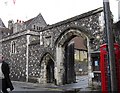
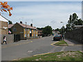
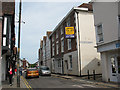
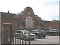
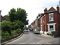
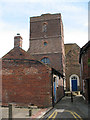
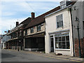
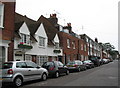
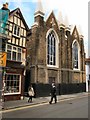
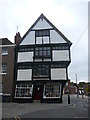
CT1 1DH is a small residential postcode area within Canterbury, Kent, encompassing a compact cluster of homes and historic sites. With a population of 2,868 spread across 8,333 square metres, the area is densely populated but retains a distinct character rooted in Canterbury’s medieval past. Situated near the former North Gate of the city’s medieval walls, the area is named after this historic landmark, which once marked the boundary of the city’s defences. Today, the postcode includes the Northgate Ward Community Centre, established in 1997, and is close to St Mary Northgate Church, a deconsecrated building now owned by King’s School. Daily life here is shaped by proximity to Canterbury’s city centre, with easy access to rail links, retail hubs like Farmfoods Canterbury, and a young demographic. The median age of 22 reflects a community dominated by young adults, many of whom may be students or early-career professionals. While the area is small, it offers a blend of historical intrigue and modern convenience, though residents should be mindful of local safety considerations.
- Area Type
- Postcode
- Area Size
- 8333 m²
- Population
- Not available
- Population Density
- Not available
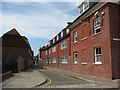
The property market in CT1 1DH is characterised by a low home ownership rate—only 29% of residents own their homes—suggesting that the area is predominantly a rental market. The accommodation type is primarily houses, which is unusual for a small postcode area, possibly indicating a mix of semi-detached or terraced properties. This combination of high population density and house-based housing stock may create a competitive environment for buyers, with limited availability of owner-occupied properties. The small size of the area means that properties are likely to be close to each other, with little scope for new development. For buyers, this could mean higher demand for existing homes, though the lack of flats or apartments may limit options for those seeking different property types. The proximity to Canterbury’s city centre and transport links may enhance the appeal of the area, but the high proportion of renters suggests that the market is more suited to those seeking short-term or flexible housing solutions.
House Prices in CT1 1DH
No properties found in this postcode.
Energy Efficiency in CT1 1DH
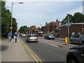
Living in CT1 1DH offers access to a range of amenities within practical reach. The area is close to retail hubs such as Farmfoods Canterbury, Asda Canterbury, and Aldi Sturry, providing everyday shopping convenience. These stores cater to both essential needs and casual spending, supporting a self-sufficient lifestyle. The proximity to three railway stations—Canterbury West, Canterbury East, and Sturry—enhances mobility, making it easy to travel to work, social events, or nearby attractions. While the data does not mention parks or leisure facilities, the area’s historical context and compact size suggest that nearby green spaces or cultural sites may be accessible. The presence of a community centre and the historical significance of St Mary Northgate Church add to the area’s character, offering opportunities for social engagement or cultural exploration. For residents prioritising convenience and connectivity, the mix of retail, transport, and historical elements creates a functional yet distinct urban environment.
Amenities
Schools
The schools near CT1 1DH include Parkside Community Primary School, a primary school with a ‘good’ Ofsted rating, and The Willows, which is categorised as an ‘other’ school type. The presence of a primary school with a strong rating is a significant asset for families, offering a reliable educational foundation for younger children. The Willows, while not further specified, may serve as a secondary or special needs school, providing additional options for older students or those with specific requirements. This mix of school types suggests a range of educational provisions, though the data does not clarify their exact roles. Families seeking a primary school with a proven track record may find Parkside Community Primary School particularly appealing, while The Willows could complement the local education landscape. However, the absence of detailed information on school performance or capacity means that prospective residents should investigate further to understand the full range of opportunities available.
| Rank | School | Type | Entry gender | Ages |
|---|---|---|---|---|
| 1 | Parkside Community Primary School | primary | N/A | N/A |
| 2 | The Willows | other | N/A | N/A |
Explore more schools in this area
Go to Schools tabDemographics
CT1 1DH has a median age of 22, with the most common age range being 15–29 years. This suggests a community skewed toward young adults, likely including students and recent graduates. Only 29% of residents own their homes, with the majority living in houses rather than flats. The predominant ethnic group is White, though no specific data on diversity beyond this is provided. The high population density of 344,164 people per square kilometre indicates a compact, possibly urbanised area with limited space for expansion. This density, combined with the young age profile, may reflect a transient population or a focus on rental properties. The low home ownership rate implies that many residents are either renting or in temporary housing, which could impact community stability. The absence of detailed deprivation data means the area’s socioeconomic challenges remain unclear, but the high proportion of young people may suggest a dynamic, though potentially less established, local economy.
Household Size
Accommodation Type
Tenure
Ethnic Group
Religion
Household Composition
Age
Household Deprivation
NS-SEC
Explore more demographic insights in this area
Go to Demographics tabPlanning
Planning Constraints
- Flood RiskPremium
- Ramsar Wetland SitesPremium
- Area of Outstanding Natural BeautyPremium
- Protected Nature ReservePremium
- Protected WoodlandPremium
- Crime RiskPremium