Area Overview for Cropredy
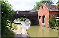
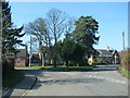
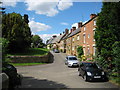
Photos of Cropredy


Area Information
Cropredy is a small built-up area in England, covering 32 hectares, with a population skewed towards older residents. The median age of 70 suggests a community largely composed of retirees or long-term residents, which shapes the area’s character. Despite its compact size, Cropredy offers a blend of practical living with access to essential services. Home ownership is high, at 78%, indicating a stable, settled population. The area is near key retail hubs like M&S Gateway M40 and Tesco Banbury, as well as Banbury Railway Station, which connects residents to broader networks. Schools in the vicinity, including the locally named Cropredy Church of England Primary School, cater to families. Daily life here is likely quiet and community-focused, with low crime risk (80/100) adding to a sense of safety. While the area lacks dense urban amenities, its proximity to transport links and retail options makes it a viable choice for those prioritising security, simplicity, and accessibility over a bustling city lifestyle.
- Area Type
- Built Up Area 250
- Area Size
- 32.0 hectares
- Population
- Not available
- Population Density
- Not available
Cropredy’s nearby amenities include five retail outlets, such as M&S Gateway M40, Co-op Hanwell, and Tesco Banbury, providing access to everyday shopping needs. The Banbury Railway Station offers a direct link to regional transport networks, enhancing mobility for those commuting or traveling. While the area lacks parks or leisure facilities, the retail options and rail connection contribute to a practical lifestyle. The presence of a primary school and the proximity to larger towns suggest that families can combine local convenience with broader opportunities. The overall character of Cropredy leans towards simplicity, with amenities designed for functionality rather than luxury. Residents may find the area ideal for those prioritising accessibility and security over a more vibrant, amenity-rich environment.
Amenities
Schools
Cropredy has one primary school listed in the data: Cropredy Church of England Primary School. While the name is repeated, it is the only school explicitly mentioned. The absence of secondary schools or other educational institutions means families may need to look beyond the immediate area for secondary education. The presence of a primary school suggests the area can meet the needs of younger children, but the lack of additional schools may limit options for older students. The school’s type is primary, but its Ofsted rating is not provided, so its quality remains unassessed. For families prioritising proximity to schools, this single primary option may be sufficient, but further research would be needed to evaluate its performance.
| Rank | A + A* % | School | Type | Entry gender | Ages |
|---|---|---|---|---|---|
| 1 | N/A | Cropredy Church of England Primary School | primary | N/A | N/A |
| 2 | N/A | Cropredy Church of England Primary School | primary | N/A | N/A |
Explore more schools in this area
Go to Schools tabDemographics
Cropredy’s population is predominantly older, with a median age of 70, reflecting a community where retirees or long-term residents form the majority. Home ownership is high at 78%, suggesting many residents are homeowners rather than renters. The data does not specify household composition or accommodation types, but the overall demographic profile indicates a stable, low-turnover population. There are no details on ethnic diversity or religious composition, but the area’s safety and accessibility may attract those seeking a quiet, secure environment. The high median age implies a need for services tailored to older adults, though the data does not confirm the presence of such facilities. The lack of specific figures on deprivation or diversity means the area’s social fabric remains largely unexplored in this context.
Household Size
Accommodation Type
Tenure
Ethnic Group
Religion
Household Composition
Age
Household Deprivation
NS-SEC
Explore more demographic insights in this area
Go to Demographics tabPlanning
Planning Constraints
- Crime RiskLocked