Area Overview for Cliftonville West Ward
Photos of Cliftonville West Ward

Area Information
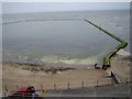
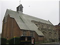
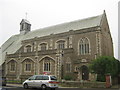
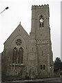
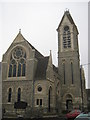
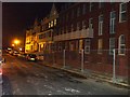
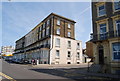
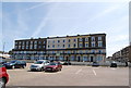
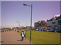
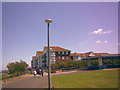
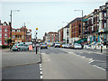
Cliftonville West Ward stands as a distinct electoral ward within the Thanet District Council, positioned in the western portion of the historic seaside town of Margate in Kent. This coastal area forms part of South East England on the Isle of Thanet, offering a landscape that blends the rugged charm of the seafront with managed urban development. The ward covers approximately 1.1 square kilometres, a compact footprint that contains a significant population density for its size. While historical records note a larger population of around 12,900 in the broader Cliftonville area based on 2005 data, current specific district figures indicate a local population of 1,561. Daily life here is heavily influenced by the presence of the proposed Dalby Square conservation area and extensive clifftop zones. These features define the visual character of the neighbourhood, providing open spaces that contrast with the dense built environment. The area includes St Paul's Church, consecrated in 1873, and sits near the Clifton Baths and Walpole Bay. You will be living in a zone where 19th-century heritage meets modern coastal living. The ward is bounded by natural boundaries and planning designations that shape your viewlines and outdoor access. Proximity to Margate's promenades and the historic Royal Sea Bathing Hospital, founded in 1791, ensures you remain connected to the wider town's amenities while enjoying the quieter atmosphere of this specific ward.
- Area Type
- District Borough Unitary Ward
- Area Size
- 1.1 km²
- Population
- Not available
- Population Density
- Not available
Demographics
The community profile in Cliftonville West Ward reflects a mature population. The median age stands at 70 years, indicating a neighbourhood where older residents form the predominant group. This demographic trend suggests a quiet residential environment where younger households may be underrepresented. Your average neighbour is likely to be senior, which often leads to a different dynamic regarding noise levels, foot traffic, and community engagement compared to younger family-heavy areas. Home ownership sits at 34%, meaning roughly one-third of households own their properties outright or are paying a mortgage. Consequently, a significant portion of residents rent their homes. This split influences the stability of the local tenant base and the nature of keyholder relationships you might encounter. The ward features a mix of accommodation types, though the data does not specify the exact breakdown between flats, terraced houses, or detached properties. You can expect a standard residential mix typical of older seaside districts. The lack of specific data on household composition or predominant ethnic groups means you cannot make claims about cultural diversity or family structures beyond what the age median implies. While archaeological remains from Neolithic to modern periods record the deep history of the land, the current social fabric is defined by this older, partially rented demographic.
Household Size
Accommodation Type
Tenure
Ethnic Group
Religion
Household Composition
Age
Household Deprivation
NS-SEC
Explore more demographic insights in this area
Go to Demographics tabPlanning
Planning Constraints
- Flood RiskPremium
- Ramsar Wetland SitesPremium
- Area of Outstanding Natural BeautyPremium
- Protected Nature ReservePremium
- Protected WoodlandPremium