Area Overview for Cippenham Village Ward
Photos of Cippenham Village Ward


Area Information
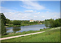
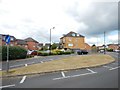
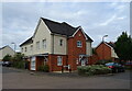
Cippenham Village Ward forms part of the Borough of Slough, a unitary authority in Berkshire situated in south-east England. This specific electoral district covers a compact 2.7 square kilometres and acts as an integral component of the wider Slough urban area. The ward extends into parts of Buckinghamshire, reflecting its historical and geographical position on the edge of a major commuter belt town. In 2011, the population statistics indicated approximately 2,550 households defined the community within these boundaries. People living in Cippenham Village Ward benefit from strategic proximity to key transport arteries. The M4 motorway serves as the principal connecting road, while six railway stations, including Taplow, Burnham, Slough, and Iver, provide rail links to London and other cities. Heathrow Airport lies just seven miles to the south-east, offering convenient access for residents who travel frequently. Daily life here is characterised by a blend of suburban convenience and regional connectivity, firmly placing you within a significant commuter corridor without isolating you from broader opportunities surrounding the borough.
- Area Type
- District Borough Unitary Ward
- Area Size
- 2.7 km²
- Population
- Not available
- Population Density
- Not available
Demographics
The community profile within Cippenham Village Ward shows an older population structure compared to many national averages. The median age stands at exactly 70 years, indicating a significant concentration of older residents. This demographic reality means the social fabric revolves heavily around the needs and lifestyles of this age group. Half of all residents own their homes outright or through a mortgage, with the home ownership rate recorded at 55%. This indicates that Cippenham Village Ward functions as a primarily owner-occupied area rather than a high-density rental market. The household composition data reflects the total population without distinguishing specific sub-categories like singles or families, suggesting diverse living arrangements that adapt to the older median age. The ward does not currently display specific data on predominant ethnic groups or religious affiliations in the available statistics. When you consider safety metrics, the area records a low crime risk with a score of 67 out of 100. This figure places the neighbourhood below the average for crime rates, suggesting you can expect a relatively secure environment for day-to-day activities.
Household Size
Accommodation Type
Tenure
Ethnic Group
Religion
Household Composition
Age
Household Deprivation
NS-SEC
Explore more demographic insights in this area
Go to Demographics tabPlanning
Planning Constraints
- Flood RiskPremium
- Ramsar Wetland SitesPremium
- Area of Outstanding Natural BeautyPremium
- Protected Nature ReservePremium
- Protected WoodlandPremium
- Crime RiskPremium