Area Overview for Chess Valley Ward
Photos of Chess Valley Ward
Area Information
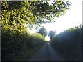
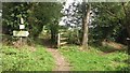
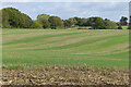
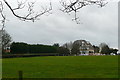
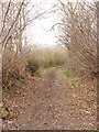
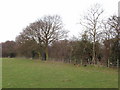
Living in Chess Valley Ward offers a distinct experience within South East England, characterised by its deep history and connection to the natural landscape. This unitary authority ward spans 24.8 km², placing it firmly in Hertfordshire near the River Chess. The area functions as a historic boundary zone, existing within specific administrative generations from 43 to 56. Your daily life here is shaped by the Chess Valley Walk, a 10-mile long-distance footpath that traces the river from Rickmansworth to Chesham. This route provides extensive access to outdoor recreation, which aligns with the ward's status within an Area of Outstanding Natural Beauty. Residents navigate a landscape where planning constraints are significant due to the AONB designation and the presence of protected woodland. These designations ensure that the natural environment remains a central feature of living in Chess Valley Ward, though they may restrict large-scale development. You are entering a location where the built environment is inextricably linked to the river valley and surrounding greenspaces. The proximity to Rickmansworth and Chesham defines your social and physical connections, anchoring this ward in a specific stretch of Hertfordshire known for its tranquil character. Understanding these geographical and administrative realities is essential for anyone serious about homes in Chess Valley Ward.
- Area Type
- District Borough Unitary Ward
- Area Size
- 24.8 km²
- Population
- Not available
- Population Density
- Not available
Demographics
The community profile of Chess Valley Ward is defined by a significant senior population and high levels of stability. Data indicates that the median age across the ward is 70 years old, suggesting a resident base that is predominantly older than the national average. This age structure creates a specific rhythm to daily life, often centred around retirement living and low-activity lifestyles. Homeownership is the dominant financial model, with 68% of households owning their properties outright or with a mortgage. Consequently, you will find a stable, settled community rather than a transient rental market. Household composition in this area reflects the older median age, with families likely comprising seniors or single-occupant households. The lack of data on specific household split types directs focus to the overarching trend of established residency. Regarding diversity, the provided information does not detail ethnic breakdown or religious affiliation, meaning the visible community character is governed by other demographic cornerstones. Present deprivation data is absent from the current records, so you cannot assess socioeconomic inequality in this specific ward. The high ownership percentage combined with the older demographic paints a picture of longevity. If you are considering homes in Chess Valley Ward, expect to join a populace where long-term residents value the quiet environment provided by the Chess Valley Walk and the surrounding nature reserves.
Household Size
Accommodation Type
Tenure
Ethnic Group
Religion
Household Composition
Age
Household Deprivation
NS-SEC
Explore more demographic insights in this area
Go to Demographics tabPlanning
Planning Constraints
- Flood RiskPremium
- Ramsar Wetland SitesPremium
- Area of Outstanding Natural BeautyPremium
- Protected Nature ReservePremium
- Protected WoodlandPremium
- Crime RiskPremium