Area Overview for BR8 7XE
Photos of BR8 7XE
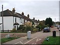
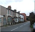
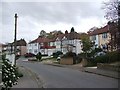
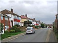
61 photos from this area
Area Information
Key information about the BR8 7XE including its size, population, and administrative classification.
- Area Type
- Postcode
- Area Size
- 7844 m²
- Population
- 1586
- Population Density
- 8330 people/km²
House Prices in BR8 7XE
24
Properties
£177,438
Average Sold Price
£64,000
Lowest Price
£281,000
Highest Price
Showing 24 properties
| Address | Type | Beds | Baths | Last Sale Price | Last Sale Date | |
|---|---|---|---|---|---|---|
| 55 Alder Way, Swanley, BR8 7XE | Terraced | 3 | 1 | £281,000 | Mar 2019 | |
| 71 Alder Way, Swanley, BR8 7XE | Terraced | 3 | 1 | £275,000 | Mar 2017 | |
| 79 Alder Way, Swanley, BR8 7XE | Terraced | 2 | - | £240,000 | Feb 2016 | |
| 47 Alder Way, Swanley, BR8 7XE | Terraced | - | - | £175,500 | Jul 2006 | |
| 59 Alder Way, Swanley, BR8 7XE | house | - | - | £150,000 | Jan 2006 | |
| 77 Alder Way, Swanley, BR8 7XE | Terraced | 3 | 1 | £120,000 | Sep 2002 | |
| 91 Alder Way, Swanley, BR8 7XE | Terraced | - | - | £114,000 | Dec 2001 | |
| 65 Alder Way, Swanley, BR8 7XE | Terraced | - | - | £64,000 | May 1998 | |
| 87 Alder Way, Swanley, BR8 7XE | Terraced | - | - | - | - | |
| 81 Alder Way, Swanley, BR8 7XE | Terraced | - | - | - | - |
Page 1 of 3
Energy Efficiency in BR8 7XE
Amenities
Schools
| Rank | School | Type | Entry gender | Ages |
|---|
Explore more schools in this area
Go to Schools tabDemographics
Household Size
Family (3-5 people)
most common
Accommodation Type
Houses
most common
Tenure
51
majority
Ethnic Group
White
most common
Religion
N/A
most common
Household Composition
N/A
most common
Age
47
median
Adults (30-64 years)
most common
Household Deprivation
N/A
with no deprivation
NS-SEC
23
in Lower managerial occupations
Explore more demographic insights in this area
Go to Demographics tabPlanning
Planning Constraints
- Flood RiskPremium
- Ramsar Wetland SitesPremium
- Area of Outstanding Natural BeautyPremium
- Protected Nature ReservePremium
- Protected WoodlandPremium