Area Overview for BR8 7EE
Photos of BR8 7EE
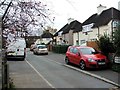
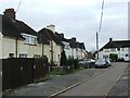
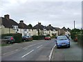
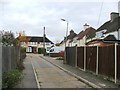
67 photos from this area
Area Information
Key information about the BR8 7EE including its size, population, and administrative classification.
- Area Type
- Postcode
- Area Size
- 4174 m²
- Population
- Not available
- Population Density
- Not available
House Prices in BR8 7EE
10
Properties
£220,071
Average Sold Price
£73,000
Lowest Price
£430,000
Highest Price
Showing 10 properties
| Address | Type | Beds | Baths | Last Sale Price | Last Sale Date | |
|---|---|---|---|---|---|---|
| 156 Hart Dyke Road, Swanley, BR8 7EE | Terraced | 3 | 1 | £430,000 | Sep 2025 | |
| 144 Hart Dyke Road, Swanley, BR8 7EE | house | - | - | £310,000 | Mar 2021 | |
| 142 Hart Dyke Road, Swanley, BR8 7EE | house | - | - | £295,000 | Feb 2021 | |
| 146 Hart Dyke Road, Swanley, BR8 7EE | house | - | - | £150,000 | Jan 2011 | |
| 152 Hart Dyke Road, Swanley, BR8 7EE | house | - | - | £165,000 | Aug 2006 | |
| 150 Hart Dyke Road, Swanley, BR8 7EE | Terraced | - | - | £117,500 | Oct 2000 | |
| 154 Hart Dyke Road, Swanley, BR8 7EE | Terraced | - | - | £73,000 | Jun 1999 | |
| 148 Hart Dyke Road, Swanley, BR8 7EE | Terraced | - | - | - | - | |
| 140 Hart Dyke Road, Swanley, BR8 7EE | Semi-detached | - | - | - | - | |
| 138 Hart Dyke Road, Swanley, BR8 7EE | Semi-detached | - | - | - | - |
Energy Efficiency in BR8 7EE
Amenities
Schools
| Rank | School | Type | Entry gender | Ages |
|---|
Explore more schools in this area
Go to Schools tabDemographics
Household Size
Family (3-5 people)
most common
Accommodation Type
Houses
most common
Tenure
44
majority
Ethnic Group
White
most common
Religion
N/A
most common
Household Composition
N/A
most common
Age
47
median
Adults (30-64 years)
most common
Household Deprivation
N/A
with no deprivation
NS-SEC
23
in Lower managerial occupations
Explore more demographic insights in this area
Go to Demographics tabPlanning
Planning Constraints
- Flood RiskPremium
- Ramsar Wetland SitesPremium
- Area of Outstanding Natural BeautyPremium
- Protected Nature ReservePremium
- Protected WoodlandPremium