Area Overview for Bonnington
Photos of Bonnington

Area Information
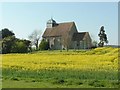
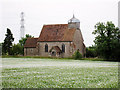
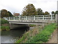
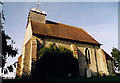
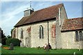
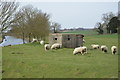
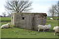
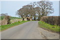
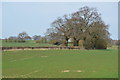
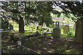
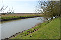
Living in Bonnington means embracing a quiet existence within a tiny rural dispersed village and civil parish in the Ashford District of Kent. You will find this location on the northern edge of Romney Marsh, situated exactly eight miles south of Ashford along the B2067 road between Hamstreet and Hythe. The parish covers a defined area of 4.7 km², spread out rather than concentrated around a single town centre. This layout suggests a lifestyle where distances matter more than in built-up areas, requiring you to plan journeys carefully if you need to visit local amenities. History permeates the daily life of the small community, with the parish holding significant ties to smuggling through the notorious Ransley Gang, a connection it shares with neighbouring Aldington. A key landmark for any visitor or resident is the Law-Day Oak, which has served local courts since at least the reign of Queen Elizabeth I and remains the site for annual parish meetings. Nearby, the tiny parish church of St Rumwold lies approximately half a mile south of the main hamlet, positioned alongside the Royal Military Canal. While the area supports under 100 inhabitants, this low density creates a distinct contrast to the more urbanised environments surrounding it. You are buying into a heritage-rich setting where governance still centres on centuries-old traditions alongside modern life.
- Area Type
- Parish
- Area Size
- 4.7 km²
- Population
- Not available
- Population Density
- Not available
Demographics
The community in Bonnington is defined by a stable and mature population structure. With a median age of 70, the household composition naturally skews towards older residents. This age profile implies a vibrant atmosphere driven by retirees rather than young professionals or families with school-aged children. You will find that 87% of households in the parish choose to own their homes, a figure that significantly outpaces national averages for owner-occupancy. This statistic reflects a deeply established residence pattern where long-term settlement is common. The remaining 13% of households likely consist of older individuals living alone or renting small properties suited to their specific needs. The accommodation type data indicates that the housing stock is predominantly private rather than social or student-oriented. This concentration of ownership supports a neighbourhood where residents have vested their significant capital in local properties. The total population figures confirm that the parish operates as a micro-community, meaning local social interactions occur within a very small circle of neighbours. When evaluating the quality of life here, you must consider that the social fabric is tightknit but potentially insular given the median age. There is no data provided on specific ethnic diversity or religious breakdown for the parish, suggesting a homogenous demographic likely mirroring the older demographic across the wider English countryside.
Household Size
Accommodation Type
Tenure
Ethnic Group
Religion
Household Composition
Age
Household Deprivation
NS-SEC
Explore more demographic insights in this area
Go to Demographics tabPlanning
Planning Constraints
- Flood RiskPremium
- Ramsar Wetland SitesPremium
- Area of Outstanding Natural BeautyPremium
- Protected Nature ReservePremium
- Protected WoodlandPremium
- Crime RiskPremium