Area Overview for BN7 2GY
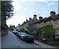
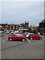
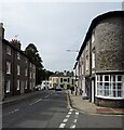
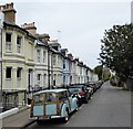
Photos of BN7 2GY
Area Information
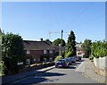
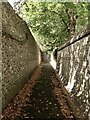
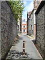
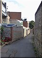
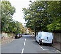
BN7 2GY is a small, tightly knit residential cluster nestled in the historic town of Lewes, East Sussex. With a population of 1,621, this area reflects the character of a traditional market town, where medieval architecture and centuries-old traditions coexist with modern living. Lewes, as the county town of East Sussex, is steeped in history, from its Norman-era castle to its annual Guy Fawkes Day celebrations, where bonfire societies parade through narrow streets. The area is defined by its compact size and proximity to the River Ouse, which has shaped its development as a communications hub and tourist destination. Daily life here is marked by a blend of quiet residential streets and access to Lewes’s vibrant commercial and cultural offerings. The town’s historic centre, lined with timber-framed buildings and Georgian facades, contrasts with newer housing estates like Wallands and South Malling, reflecting its evolution over centuries. For those seeking a balance between heritage and convenience, BN7 2GY offers a glimpse into a community where history is woven into everyday life.
- Area Type
- Postcode
- Area Size
- Not available
- Population
- 1621
- Population Density
- Not available
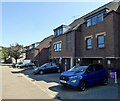
The property market in BN7 2GY is characterised by a high rate of home ownership (66%) and a predominance of houses over flats. This indicates a residential area where family homes and semi-detached properties are the norm, reflecting the town’s historic development as a market town with suburban extensions. The compact nature of the postcode suggests a limited supply of properties, which may make the market competitive for buyers. The presence of housing estates like Wallands and South Malling, added in the 20th century, provides a mix of older and newer stock, though the exact age of properties is not specified. For buyers, this area offers a blend of traditional architecture and modern living, with the potential for long-term investment in a stable community. However, the small size of the postcode means that buyers may need to look beyond BN7 2GY to find additional options, particularly for larger or newer properties.
House Prices in BN7 2GY
No properties found in this postcode.
Energy Efficiency in BN7 2GY
Living in BN7 2GY offers access to a range of amenities within practical reach. Retail options include major supermarkets such as Tesco Lewes, Aldi Lewes, and Waitrose Lewes, ensuring convenience for grocery shopping. The area’s rail stations, including Lewes and Glynde, provide links to nearby towns and cities, enhancing mobility for commuters. The town’s historic character is complemented by its modern amenities, with a focus on community and heritage. Residents can enjoy the medieval architecture, local festivals, and the River Ouse’s proximity, which adds to the area’s charm. The blend of retail, transport, and cultural offerings supports a lifestyle that balances practicality with the appeal of a historic market town.
Amenities
Schools
BN7 2GY is served by a range of schools, including independent and primary institutions. Lewes Old Grammar School and Lewes New School are both independent, offering fee-paying education with a focus on academic and extracurricular excellence. Pells CofE Junior School is a primary school, providing early education within a Church of England framework. The mix of school types caters to different family needs, from state-funded primary education to independent secondary options. For families seeking a broad educational spectrum, the proximity of these schools offers flexibility, though specific Ofsted ratings are not provided. The presence of both independent and state schools reflects Lewes’s role as an educational hub, with institutions that have historical ties to the town’s heritage. Parents should consider the specific requirements of their children when evaluating these options.
| Rank | School | Type | Entry gender | Ages |
|---|
Explore more schools in this area
Go to Schools tabDemographics
BN7 2GY has a median age of 47, with the majority of residents falling within the 30–64 age range. This suggests a mature, stable population, likely comprising professionals, families, and retirees. Home ownership is high at 66%, indicating a community of long-term residents rather than transient renters. The predominant accommodation type is houses, which aligns with the area’s suburban and semi-rural character. The predominant ethnic group is White, reflecting broader trends in the region. The absence of specific data on deprivation or diversity means the area’s social fabric remains largely unexplored in public records. However, the demographic profile points to a community with established roots, where family homes and local traditions are central to life. This age group and ownership pattern suggest a focus on stability, with residents prioritising long-term residency over frequent relocation.
Household Size
Accommodation Type
Tenure
Ethnic Group
Religion
Household Composition
Age
Household Deprivation
NS-SEC
Explore more demographic insights in this area
Go to Demographics tabPlanning
Planning Constraints
- Flood RiskPremium
- Ramsar Wetland SitesPremium
- Area of Outstanding Natural BeautyPremium
- Protected Nature ReservePremium
- Protected WoodlandPremium
- Crime & SafetyPremium