Area Overview for BN6 8UR
Photos of BN6 8UR
Area Information
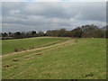
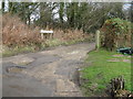
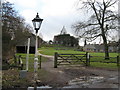
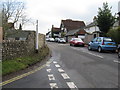
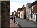
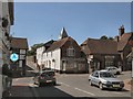
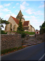
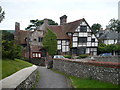
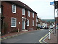
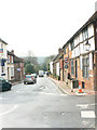
BN6 8UR lies within the historic village of Ditchling in East Sussex, a small residential cluster nestled in the South Downs National Park. Covering just 3.9 hectares, this area is home to 2,554 residents, with a population density of 107 people per square kilometre. The village sits on a hilltop, straddling the watershed between the Adur and Ouse rivers, and is crossed by the Roman Greensand Way. Its character is defined by a blend of rural tranquillity and historic charm, with over 40 listed buildings, including St Margaret’s Church and the Tudor Wings Place. The biennial Ditchling Fair, granted in 1312, remains a key event, reflecting the village’s enduring traditions. Living here offers proximity to nature, with the South Downs’ open landscapes nearby, while the village itself retains a strong artistic and cultural legacy from the Arts and Crafts movement. The area’s small size and low population density create a close-knit community, ideal for those seeking a peaceful, historically rich environment.
- Area Type
- Postcode
- Area Size
- 3.9 hectares
- Population
- 2554
- Population Density
- 107 people/km²
BN6 8UR is characterised by a high rate of home ownership (83%), with houses being the predominant accommodation type. This suggests a market dominated by owner-occupied properties, likely attracting families and long-term residents seeking stability. The small area size and limited housing stock mean the market is likely tight, with limited new developments. Buyers should consider the proximity to amenities such as rail stations and schools, which enhance the area’s appeal. The prevalence of houses, rather than flats or apartments, indicates a preference for traditional, spacious living. However, the small size of the postcode area means that property choices may be constrained, requiring buyers to look beyond BN6 8UR for broader options. The low crime risk and absence of planning constraints further support the area’s desirability for homeowners.
House Prices in BN6 8UR
Showing 35 properties
| Address | Type | Beds | Baths | Last Sale Price | Last Sale Date | |
|---|---|---|---|---|---|---|
| 111 East End Lane, Ditchling, BN6 8UR | house | - | - | £615,000 | Oct 2025 | |
| 88 East End Lane, Ditchling, BN6 8UR | Semi-detached | 2 | 1 | £500,000 | Jan 2025 | |
| 101 East End Lane, Ditchling, BN6 8UR | house | - | - | £1,000,000 | Mar 2024 | |
| 60 East End Lane, Ditchling, BN6 8UR | Terraced | 3 | 2 | £585,000 | Jan 2024 | |
| 65 East End Lane, Ditchling, BN6 8UR | Semi-detached | 2 | - | £1,080,000 | Jul 2023 | |
| 90 East End Lane, Ditchling, BN6 8UR | house | - | - | £690,100 | Nov 2022 | |
| 66 East End Lane, Ditchling, BN6 8UR | Terraced | 3 | - | £699,950 | Apr 2022 | |
| 62 East End Lane, Ditchling, BN6 8UR | Terraced | 2 | - | £700,000 | Mar 2022 | |
| 78 East End Lane, Ditchling, BN6 8UR | Detached | 5 | 3 | £1,740,000 | Mar 2021 | |
| 55 East End Lane, Ditchling, BN6 8UR | Bungalow | - | - | £555,000 | Aug 2020 |
Energy Efficiency in BN6 8UR
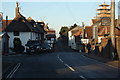
BN6 8UR offers a mix of practical amenities and rural charm. Within reach are five retail outlets, including Morrisons Daily Hassocks 44, Sainsburys Hassocks, and Co-op Burgess, providing everyday shopping needs. The area’s rail stations connect residents to nearby towns, enhancing access to larger retail, dining, and leisure options. The village itself retains a historic character, with listed buildings, the Ditchling Museum of Art + Craft, and the biennial fair contributing to a culturally rich environment. While the data does not specify parks or green spaces, the proximity to the South Downs National Park suggests opportunities for outdoor activities. The combination of local shops, rail links, and heritage sites creates a lifestyle that balances convenience with a traditional, low-key rural setting.
Amenities
Schools
BN6 8UR is served by two primary schools: Ditchling (St Margaret’s) Church of England Primary School and Ditchling St Margaret’s Church of England Primary School. Both are primary institutions, though their identical names suggest potential duplication or administrative oversight. The presence of two primary schools within the area provides families with multiple options for early education. However, the data does not include secondary schools or Ofsted ratings, so parents should verify the quality and capacity of these schools independently. The concentration of primary education supports the area’s appeal to families, though the lack of secondary schooling may require residents to commute to nearby towns. The schools’ religious affiliation reflects the village’s historical ties to the Church of England.
| Rank | School | Type | Entry gender | Ages |
|---|
Explore more schools in this area
Go to Schools tabDemographics
BN6 8UR has a median age of 47, with the elderly (65+ years) forming the most common age group. Home ownership is high at 83%, indicating a stable, long-term resident base. The area is predominantly composed of houses, reflecting a traditional, family-oriented housing stock. The predominant ethnic group is White, which aligns with the broader demographic patterns of rural East Sussex. The low population density of 107 people per square kilometre suggests a spread-out, less congested living environment. While the data does not specify deprivation levels, the high home ownership and low crime risk suggest a relatively affluent and secure community. The absence of significant diversity data implies a homogenous population, which may influence local social dynamics and community cohesion.
Household Size
Accommodation Type
Tenure
Ethnic Group
Religion
Household Composition
Age
Household Deprivation
NS-SEC
Explore more demographic insights in this area
Go to Demographics tabPlanning
Planning Constraints
- Flood RiskPremium
- Ramsar Wetland SitesPremium
- Area of Outstanding Natural BeautyPremium
- Protected Nature ReservePremium
- Protected WoodlandPremium