Area Overview for BN43 6PR
Photos of BN43 6PR


Area Information
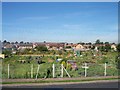
BN43 6PR is a small residential cluster in England, home to 1,871 people. Its compact size means it is likely a tight-knit community, with residents living in proximity to local amenities and transport links. The area’s demographics suggest a mature population, with a median age of 47 and most residents aged between 30 and 64. This hints at a stable, established community, possibly with families and professionals. The presence of flats as the predominant accommodation type indicates a mix of older housing stock and possibly purpose-built residential developments. While specific historical or cultural context is not provided, the area’s proximity to Shoreham and its rail connections suggest it may be part of a broader commuter belt. Living here offers access to nearby shops, transport hubs, and airports, though the small population implies a quiet, low-density environment. For buyers, the area’s size and characteristics mean it is unlikely to have sprawling developments, focusing instead on functional, community-oriented living.
- Area Type
- Postcode
- Area Size
- Not available
- Population
- 1871
- Population Density
- 6368 people/km²
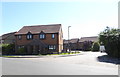
The property market in BN43 6PR is characterised by a 53% home ownership rate, with flats making up the majority of accommodation types. This suggests a housing stock that is likely older, with a focus on multi-unit developments or converted buildings. The relatively low home ownership percentage indicates a significant portion of the area is rented, possibly attracting tenants seeking affordable or stable housing. Flats may dominate due to their efficiency in smaller spaces, aligning with the area’s compact nature. For buyers, this means the market is unlikely to have large detached homes, instead offering more modest, functional properties. The small population and limited area size suggest a limited inventory of properties, which could mean competition for available homes. Investors or buyers should consider the area’s proximity to transport links and amenities, which may enhance its appeal despite the lack of expansive housing options.
House Prices in BN43 6PR
No properties found in this postcode.
Energy Efficiency in BN43 6PR
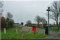
Residents of BN43 6PR have access to a range of nearby amenities, including five retail outlets such as Co-op Shoreham and Lidl Shoreham, ensuring everyday shopping needs are met. The area’s rail network, with stations like Shoreham and Fishersgate, provides direct links to surrounding towns and cities, facilitating commuting or leisure travel. Two airports are within reach, offering additional travel flexibility for those requiring air connections. While specific parks or leisure facilities are not detailed, the proximity to rail and retail suggests a balance between convenience and practicality. The presence of multiple shops and transport hubs implies a lifestyle that prioritises accessibility over sprawling green spaces. For those valuing ease of movement and local services, BN43 6PR offers a compact environment where essential amenities are within walking or short-vehicle distance, supporting a straightforward, functional daily routine.
Amenities
Schools
| Rank | School | Type | Entry gender | Ages |
|---|
Explore more schools in this area
Go to Schools tabDemographics
BN43 6PR has a median age of 47, with the majority of residents aged between 30 and 64. This suggests a population skewed toward working-age adults, possibly including professionals and families. Home ownership is at 53%, slightly below the national average, indicating a mix of owner-occupied and rental properties. The area’s accommodation is predominantly flats, which may reflect older housing stock or purpose-built blocks. The predominant ethnic group is White, though specific data on diversity or deprivation levels is not provided. The age profile implies a community with a strong presence of middle-aged individuals, potentially with established careers and family ties. This demographic may influence local services and amenities, with a focus on practical needs over youth-oriented facilities. The lack of data on deprivation means it is unclear how economic challenges might affect quality of life, but the stable age range suggests a relatively consistent demand for housing and services.
Household Size
Accommodation Type
Tenure
Ethnic Group
Religion
Household Composition
Age
Household Deprivation
NS-SEC
Explore more demographic insights in this area
Go to Demographics tabPlanning
Planning Constraints
- Flood RiskPremium
- Ramsar Wetland SitesPremium
- Area of Outstanding Natural BeautyPremium
- Protected Nature ReservePremium
- Protected WoodlandPremium