Area Overview for BN43 5PA
Photos of BN43 5PA


Area Information
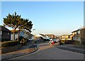
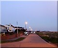
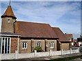
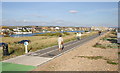
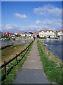
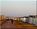
BN43 5PA is a small, tightly knit residential area in the Adur district of West Sussex, nestled within the village of Lancing. With a population of 1,511 and a density of 754 people per square kilometre, it reflects a compact, suburban character shaped by its coastal location and historical roots. Lancing itself is a village with Saxon origins, evolving from a quiet agricultural hamlet into a modern suburb connected to Brighton, Worthing, and Littlehampton. The area’s proximity to the River Adur and the South Downs offers a blend of natural and built environments, while its position on the western edge of the Adur Valley ensures a quieter, more residential vibe compared to larger towns. Daily life here is defined by a mix of historical charm and practical modernity: the village’s 19th-century market gardening legacy has given way to housing, but landmarks like Lancing College Chapel and St James the Less Church remain prominent. Residents benefit from easy access to nearby transport networks, including multiple railway stations and two airports, making it a strategic location for commuters or those seeking a balance between rural tranquillity and urban connectivity.
- Area Type
- Postcode
- Area Size
- Not available
- Population
- 1511
- Population Density
- 754 people/km²
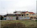
The property market in BN43 5PA is characterised by a focus on houses, with 48% of homes owned by residents. This indicates a predominantly owner-occupied market, though the relatively low home ownership rate suggests a significant proportion of properties may be rented. The area’s housing stock is likely to include a range of detached and semi-detached homes, reflecting its suburban nature. Given the small size of the postcode and its integration into Lancing’s broader residential fabric, property availability may be limited, with buyers needing to consider nearby areas for more options. The presence of established infrastructure, including rail links and retail amenities, makes the area appealing to those seeking a balance between convenience and space. However, the lack of specific data on property prices or recent trends means buyers should conduct local market research to gauge current conditions.
House Prices in BN43 5PA
No properties found in this postcode.
Energy Efficiency in BN43 5PA
Living in BN43 5PA offers access to a range of amenities that cater to daily needs and leisure. The area’s retail options include five notable stores, such as Waitrose Little Waitrose, Budgens Shoreham, and Co-op Shoreham, providing convenience for shopping and groceries. For transport, five railway stations—Shoreham, Lancing, and Southwick—offer regular connections to nearby cities, while two airports provide alternative travel routes. The village’s historical character adds to its appeal, with landmarks like Lancing College Chapel, St James the Less Church, and the Lancing Ring archaeological site offering cultural and recreational value. The surrounding landscape, including the River Adur and the South Downs, provides opportunities for walking or cycling. This mix of practical amenities and historical richness creates a lifestyle that blends modern convenience with a sense of place.
Amenities
Schools
| Rank | School | Type | Entry gender | Ages |
|---|
Explore more schools in this area
Go to Schools tabDemographics
BN43 5PA has a median age of 47, with the majority of residents falling within the 30–64 age range. This suggests a community of middle-aged and older adults, likely with established careers and families. Home ownership stands at 48%, slightly below the national average, indicating a mix of owner-occupied and rental properties. The area is predominantly composed of houses, reflecting a preference for single-family dwellings over flats or apartments. The predominant ethnic group is White, though specific data on diversity or minority representation is not provided. The age profile and home ownership rate suggest a stable, long-term resident base, with fewer young families or transient populations. The absence of detailed deprivation data means the area’s quality of life cannot be fully contextualised, but the low crime risk and lack of environmental constraints point to a generally secure and manageable living environment.
Household Size
Accommodation Type
Tenure
Ethnic Group
Religion
Household Composition
Age
Household Deprivation
NS-SEC
Explore more demographic insights in this area
Go to Demographics tabPlanning
Planning Constraints
- Flood RiskPremium
- Ramsar Wetland SitesPremium
- Area of Outstanding Natural BeautyPremium
- Protected Nature ReservePremium
- Protected WoodlandPremium