Area Overview for BN43 5FG
Photos of BN43 5FG

Area Information
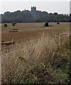
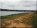
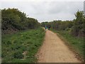
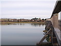
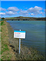
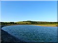
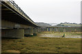
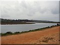
BN43 5FG is a small, tightly knit residential postcode area in England, covering 19.5 hectares with a population of 1,511 people. Its compact size and moderate density of 754 people per square kilometre suggest a community-oriented environment, where daily life is shaped by proximity to local amenities and natural surroundings. Situated in the Adur district of West Sussex, this area is part of the larger Lancing parish, a coastal village with Saxon origins and a history of market gardening. While the modern character of BN43 5FG leans suburban, it retains traces of its agricultural past, with the River Adur forming part of its eastern boundary. The area’s small footprint means residents are likely to know their neighbours, and the mix of housing types and ownership levels reflects a balance between long-term residents and newer arrivals. Living here offers a blend of quiet suburban life and access to nearby coastal and rural landscapes, though the high flood risk in the region is a notable consideration for prospective buyers.
- Area Type
- Postcode
- Area Size
- 19.5 hectares
- Population
- 1511
- Population Density
- 754 people/km²
The property market in BN43 5FG is characterised by a predominance of houses, with 48% of properties owned by residents. This suggests a mix of owner-occupied homes and rental properties, though the exact balance between the two is not specified. Given the area’s small size and the focus on houses, the housing stock is likely to be limited in volume, potentially making it a competitive market for buyers. The presence of a significant rental segment implies that some properties may be targeted at tenants, particularly those seeking family-friendly homes in a suburban setting. For buyers, the small area means that the immediate surroundings are critical to consider, as the local housing supply is constrained. The lack of high-density development or apartment blocks further reinforces the area’s appeal to those prioritising private, standalone homes.
House Prices in BN43 5FG
Showing 75 properties
Energy Efficiency in BN43 5FG
Living in BN43 5FG offers access to a range of local amenities within practical reach. The area is served by five retail outlets, including Waitrose, Budgens, and Co-op, providing essential shopping and dining options. For transport, five railway stations—Shoreham, Lancing, and Southwick—offer regular services along the West Coastway Line, facilitating travel to nearby towns and cities. The proximity to two airports, Shoreham Airport and Shoreham Brighton City Airport, adds to the area’s connectivity. While the data does not specify parks or leisure facilities, the broader Lancing parish includes historical sites like St James the Less Church and Lancing College Chapel, which contribute to the area’s cultural and architectural character. The combination of retail access, rail links, and nearby historical attractions creates a lifestyle that balances convenience with a touch of heritage.
Amenities
Schools
| Rank | School | Type | Entry gender | Ages |
|---|
Explore more schools in this area
Go to Schools tabDemographics
The population of BN43 5FG has a median age of 47, with the majority of residents falling into the 30–64 age range. This suggests a mature, stable community, likely centred around families and professionals. Home ownership accounts for 48% of properties, with the remaining 52% occupied by renters, indicating a mix of owner-occupied and rental housing. The predominant accommodation type is houses, reflecting a preference for single-family homes in this area. The dominant ethnic group is White, which aligns with broader demographic trends in the region. The age profile and ownership figures suggest a community that is neither overly young nor transient, with a focus on established households. However, the absence of specific data on deprivation or diversity metrics means the area’s social dynamics remain largely defined by its age and housing composition.
Household Size
Accommodation Type
Tenure
Ethnic Group
Religion
Household Composition
Age
Household Deprivation
NS-SEC
Explore more demographic insights in this area
Go to Demographics tabPlanning
Planning Constraints
- Flood RiskPremium
- Ramsar Wetland SitesPremium
- Area of Outstanding Natural BeautyPremium
- Protected Nature ReservePremium
- Protected WoodlandPremium