Area Overview for BN4 1EN
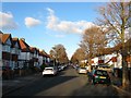
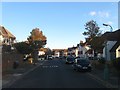
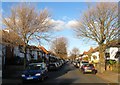
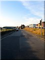
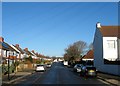
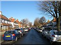
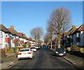
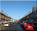
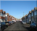
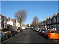
Photos of BN4 1EN

Area Information
BN4 1EN lies within the Portslade area of Brighton and Hove, a small residential cluster with a population of 1,853. It sits on the western edge of the city, bordered by Hove and Southwick, and is steeped in history. The area’s character blends historic architecture with modern living, from the 12th-century St Nicolas Church to 19th-century industrial sites now repurposed. Daily life here is shaped by its proximity to transport links, including multiple railway stations and nearby airports, while the community retains a distinct local identity. The area’s compact size means amenities are within easy reach, and its mix of older homes and recent developments caters to a range of lifestyles. With a median age of 47, the population skews towards adults in their 30s to 60s, suggesting a stable, established community. Living in BN4 1EN offers a balance of historical charm and practical convenience, though its small size means the area is best suited for those prioritising proximity to Brighton’s wider amenities.
- Area Type
- Postcode
- Area Size
- Not available
- Population
- Not available
- Population Density
- Not available
BN4 1EN is characterised by a home ownership rate of 61%, with houses forming the predominant accommodation type. This suggests a market skewed towards owner-occupied properties rather than rentals, likely reflecting the area’s historical development as a residential hub. The presence of older homes, many dating to the 19th and early 20th centuries, indicates a mix of traditional and possibly characterful properties. However, the small size of the postcode area means the housing stock is limited, and buyers may need to consider nearby areas for more options. The focus on houses rather than flats or apartments aligns with the demographic profile of older, established residents. For those seeking a stable, low-turnover market, BN4 1EN offers a niche opportunity, though its compact size may require flexibility in property searches.
House Prices in BN4 1EN
No properties found in this postcode.
Energy Efficiency in BN4 1EN
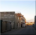
BN4 1EN offers a range of amenities within practical reach, including five retail outlets such as M&S Hove BP, Tesco Portslade, and Iceland Portslade, ensuring everyday shopping needs are met. The main shopping area, Station Road/Boundary Road, straddles the Portslade-Hove boundary and serves as a local hub. For leisure, the area’s historical landmarks—such as St Nicolas Church and Easthill House, now a community centre and park—provide cultural and recreational value. The proximity to the former Portslade Fire Station and Portslade Town Hall adds to the area’s heritage appeal. While the small postcode size limits the density of amenities, the mix of retail, transport, and green spaces supports a convenient, community-focused lifestyle.
Amenities
Schools
The nearest school to BN4 1EN is St Peter’s Community Primary School, a primary institution serving the local area. No specific Ofsted rating is provided, but the presence of a primary school suggests the area is well-suited for families with young children. The absence of secondary schools in the immediate vicinity may require residents to look further afield, though Brighton and Hove’s broader network of schools is accessible via transport links. The single school listed reflects the small scale of the postcode area, which may limit the diversity of educational options. For families prioritising proximity to schools, St Peter’s provides a foundational resource, but additional research into secondary education options would be necessary.
| Rank | School | Type | Entry gender | Ages |
|---|
Explore more schools in this area
Go to Schools tabDemographics
The population of BN4 1EN has a median age of 47, with the majority of residents falling within the 30–64 age range. Home ownership rates stand at 61%, reflecting a community where many residents live in their own homes. The predominant accommodation type is houses, indicating a focus on family-friendly or semi-detached properties. The predominant ethnic group is White, though no further breakdown of diversity is provided. This age profile suggests a mature, settled population, likely with established careers and families. The relatively high home ownership rate implies stability, though the absence of specific data on deprivation or income levels means the area’s economic diversity remains unquantified. For buyers, this demographic profile points to a community prioritising long-term residency over transient rental markets.
Household Size
Accommodation Type
Tenure
Ethnic Group
Religion
Household Composition
Age
Household Deprivation
NS-SEC
Explore more demographic insights in this area
Go to Demographics tabPlanning
Planning Constraints
- Flood RiskPremium
- Ramsar Wetland SitesPremium
- Area of Outstanding Natural BeautyPremium
- Protected Nature ReservePremium
- Protected WoodlandPremium