Area Overview for BN3 8YF
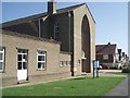
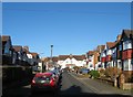
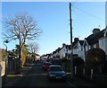
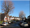
Photos of BN3 8YF
Area Information
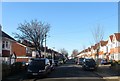
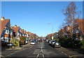
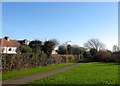
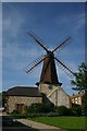
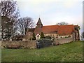
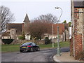
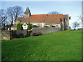
BN3 8YF is a small, residential postcode area nestled within the Hangleton & Knoll ward of Hove, part of Brighton & Hove’s unitary authority. With a population of just 1,588, it is a tight-knit suburban cluster centred around historic landmarks like St Helen’s Church and Hangleton Manor, now a pub. The area’s character is defined by 20th-century housing developments, including terraced and semi-detached homes, alongside private bungalows on higher ground offering views of the South Downs and sea. This mix of architectural styles caters to families and retirees, with a strong local identity shaped by its proximity to both urban amenities and natural landscapes. Daily life here is grounded in community, with shopping parades, schools, and pubs forming the social backbone. The area’s historical roots, from medieval village life to 1930s–1950s council housing, create a layered sense of place that balances tradition with modern convenience.
- Area Type
- Postcode
- Area Size
- Not available
- Population
- Not available
- Population Density
- Not available
BN3 8YF is predominantly an owner-occupied area, with 72% of homes owned outright. The housing stock is largely composed of houses, including a mix of 1930s–1950s council housing, terraced and semi-detached properties, and private bungalows. This reflects a suburban layout designed for family living, with a focus on private, detached or semi-detached homes. The small size of the area means the housing market is limited, with fewer properties available compared to larger urban centres. For buyers, this could mean higher competition for available homes, particularly bungalows on higher ground offering views. The predominance of owner-occupied properties also suggests a community with long-term residency, which may influence the local property market’s stability and demand.
House Prices in BN3 8YF
No properties found in this postcode.
Energy Efficiency in BN3 8YF
BN3 8YF offers a suburban lifestyle with a range of amenities within walking distance. Retail options include Co-op Hangleton, Tesco Westway, and Sainsburys West, providing everyday shopping convenience. The area’s character is defined by a mix of local pubs, churches, and community spaces, such as the historic St Helen’s Church and Hangleton Manor Inn. While the data does not list parks or leisure facilities explicitly, the area’s description suggests access to green spaces through its proximity to the South Downs. The combination of retail, dining, and cultural landmarks creates a balanced environment that supports both daily needs and leisure activities.
Amenities
Schools
The nearest school to BN3 8YF is West Blatchington Junior School, a primary school serving the local community. While no Ofsted rating is provided, the area’s character description highlights its popularity with families, suggesting the school plays a key role in the area’s appeal. The presence of a primary school within practical reach supports the area’s reputation as family-friendly, though the absence of secondary schools nearby may require residents to travel to neighbouring wards for comprehensive education. The lack of additional schools in the data means the educational landscape is currently limited to primary-level provision.
| Rank | School | Type | Entry gender | Ages |
|---|
Explore more schools in this area
Go to Schools tabDemographics
BN3 8YF has a median age of 47, with the majority of residents aged 30–64, reflecting a community skewed toward middle-aged adults. Home ownership is high, at 72%, with the predominant accommodation type being houses. The area’s demographic profile is largely homogenous, with the White ethnic group forming the majority. This suggests a stable, long-term resident base, likely shaped by the area’s suburban appeal and historical development patterns. The absence of specific data on deprivation or diversity means the community’s socio-economic profile remains largely defined by its age and ownership statistics. The presence of a significant proportion of under-16s, noted in the area’s character description, indicates a family-friendly environment, though this is not quantified in the provided data.
Household Size
Accommodation Type
Tenure
Ethnic Group
Religion
Household Composition
Age
Household Deprivation
NS-SEC
Explore more demographic insights in this area
Go to Demographics tabPlanning
Planning Constraints
- Flood RiskPremium
- Ramsar Wetland SitesPremium
- Area of Outstanding Natural BeautyPremium
- Protected Nature ReservePremium
- Protected WoodlandPremium