Area Overview for BN3 6BS
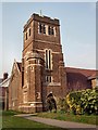
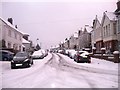
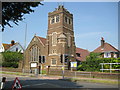
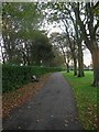
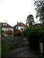
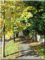
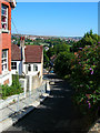
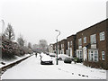
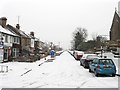
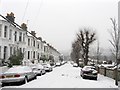
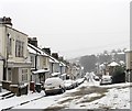
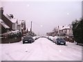
Photos of BN3 6BS
Area Information
BN3 6BS is a small residential postcode area in the heart of Brighton and Hove, England, encompassing a cluster of homes that reflect the region’s suburban character. With a population of 1,651, this area is part of the Westdene & Hove Park electoral ward, a historically farmland-based suburb developed in the 1920s and 1930s. Its proximity to Hove and central Brighton offers a balance of residential tranquillity and urban accessibility. The area is defined by its established housing stock, predominantly owner-occupied homes, and a community rooted in long-term residency. Residents benefit from nearby green spaces, including Hove Park, though the area itself is more residential than parkland. The demographic profile suggests a mature population, with a median age of 47 and a strong presence of adults aged 30–64. This makes BN3 6BS a stable, family-oriented neighbourhood where daily life is shaped by local amenities and a low crime rate. Its compact size means it is ideal for those seeking a quieter alternative to Brighton’s bustling core, yet within reach of its cultural and economic hubs.
- Area Type
- Postcode
- Area Size
- Not available
- Population
- Not available
- Population Density
- Not available
BN3 6BS is a predominantly owner-occupied area, with 82% of properties owned by their residents. The accommodation type is exclusively houses, reflecting a suburban layout that prioritises private, family-oriented living. This contrasts with areas where flats or rental properties dominate, making BN3 6BS a more established, low-density neighbourhood. The high home ownership rate suggests a community with long-term residency, where properties are likely to be well-maintained and valued. As a small postcode area, the housing stock is limited, which may mean fewer options for buyers but a more cohesive, stable market. The presence of houses rather than apartments or commercial units indicates a focus on residential comfort over investment potential. For buyers, this means a market that is less speculative and more rooted in local demand, though the limited size of the area may require looking to nearby wards for additional options.
House Prices in BN3 6BS
No properties found in this postcode.
Energy Efficiency in BN3 6BS
The lifestyle in BN3 6BS is shaped by its proximity to essential amenities and retail hubs. Within practical reach are five retail outlets, including major supermarkets like Tesco Hove, Waitrose Hove, and Lidl Brighton Gold, ensuring easy access to groceries and daily essentials. The area’s rail network, with stations at Hove, Preston Park, and Aldrington, connects residents to Brighton’s cultural and economic centres, while nearby airports provide additional travel options. Though the area itself is residential, its location near Hove Park offers green space for leisure, though this is not explicitly listed in the nearby amenities. The combination of retail, transport, and local services creates a convenient, self-contained environment. Residents can enjoy the benefits of suburban living without sacrificing accessibility, making BN3 6BS ideal for those seeking a balance between convenience and tranquillity.
Amenities
Schools
Residents of BN3 6BS have access to a range of educational institutions, including two primary schools with strong Ofsted ratings. Cottesmore St Mary’s Catholic Primary School and Cardinal Newman Catholic School both offer good and outstanding ratings, respectively, ensuring high-quality early education for families. For secondary education, Brighton Hove and Sussex Sixth Form College provides sixth-form provision, while Lancing College Preparatory School At Hove offers independent schooling. This mix of state and independent options allows families to choose between publicly funded education and private alternatives. The presence of both primary and secondary institutions within reach reduces the need for long commutes, supporting a family-friendly lifestyle. The strong Ofsted ratings suggest that local schools are performing well, which is a key consideration for homebuyers prioritising education quality.
| Rank | School | Type | Entry gender | Ages |
|---|
Explore more schools in this area
Go to Schools tabDemographics
The community in BN3 6BS is predominantly composed of adults aged 30–64, with a median age of 47. This suggests a mature, established population, many of whom are likely long-term residents. Home ownership is high, with 82% of properties owner-occupied, indicating a stable housing market and a community with a strong sense of place. The accommodation type is primarily houses, which aligns with the area’s suburban character and suggests a focus on family-friendly living. The predominant ethnic group is White, though no specific diversity statistics are provided. The absence of detailed data on deprivation or income levels means the area’s quality of life cannot be fully assessed, but the high home ownership rate and low crime score imply a relatively affluent and secure environment. The demographic profile suggests a community that values stability, with limited turnover and a focus on long-term residency.
Household Size
Accommodation Type
Tenure
Ethnic Group
Religion
Household Composition
Age
Household Deprivation
NS-SEC
Explore more demographic insights in this area
Go to Demographics tabPlanning
Planning Constraints
- Flood RiskPremium
- Ramsar Wetland SitesPremium
- Area of Outstanding Natural BeautyPremium
- Protected Nature ReservePremium
- Protected WoodlandPremium