Area Overview for BN3 5AL
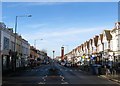
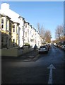
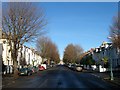
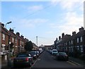
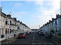
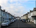
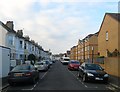
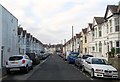
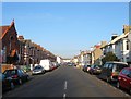
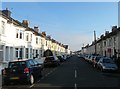
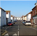
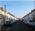
Photos of BN3 5AL
Area Information
BN3 5AL lies within the Hove area of Brighton & Hove, a small residential cluster defined by its proximity to local amenities and transport links. With a population of 1,689, the area is part of the Westbourne & Poets’ Corner electoral ward, which underwent boundary changes in recent years. This postcode sits within a historically established community, reflecting the broader demographic trends of the region. Daily life here is shaped by its integration with Hove’s infrastructure, including nearby rail stations and retail hubs. The area’s compact size means residents have easy access to both urban conveniences and the quieter aspects of suburban living. Its location within the South East region ensures connectivity to larger cities like Brighton, just a short journey away. The ward’s electorate of 7,466 and previous census population of nearly 10,000 highlight its role as a stable, long-term residential area. Living in BN3 5AL offers a blend of practicality and accessibility, with minimal environmental constraints and a low crime risk, making it appealing for those seeking a balanced lifestyle.
- Area Type
- Postcode
- Area Size
- Not available
- Population
- 1689
- Population Density
- 15741 people/km²
The property market in BN3 5AL is characterised by a strong presence of owner-occupied homes, with 58% of properties owned by residents. This suggests a community with long-term residents rather than a transient rental market. The predominant accommodation type is houses, which is typical for suburban areas and may appeal to those seeking more space or privacy. Given the area’s small size, the housing stock is likely limited, meaning buyers should consider nearby zones for additional options. The lack of high-density housing or commercial properties indicates a focus on residential living. For buyers, the low crime risk and absence of planning constraints make BN3 5AL an attractive prospect, though the limited property pool may require flexibility in location. The market is likely stable, with homes retaining value due to the area’s safety and connectivity.
House Prices in BN3 5AL
No properties found in this postcode.
Energy Efficiency in BN3 5AL
Residents of BN3 5AL have access to a range of nearby amenities that support daily life. Within practical reach are five retail outlets, including Co-op Hove, Sainsburys Hove, and Lidl Brighton Gold, ensuring convenience for grocery shopping and other needs. The area’s rail network, with stations like Aldrington and Hove, provides easy access to Brighton and other regional hubs. Two airports, Shoreham Brighton City Airport and Shoreham Airport, cater to those requiring air travel. While the area lacks major parks or leisure facilities, its proximity to Hove and Brighton means residents can enjoy cultural and recreational opportunities in nearby towns. The presence of multiple retail and transport options contributes to a practical, efficient lifestyle, with minimal need to travel far for essentials.
Amenities
Schools
| Rank | School | Type | Entry gender | Ages |
|---|
Explore more schools in this area
Go to Schools tabDemographics
The community in BN3 5AL is predominantly composed of adults aged 30–64, with a median age of 47. This suggests a mature, established population, likely with strong ties to the area. Home ownership rates stand at 58%, indicating a mix of owner-occupied properties and rentals. The accommodation type is primarily houses, which aligns with the area’s residential character. The predominant ethnic group is White, reflecting broader patterns in the region. While specific deprivation data is not provided, the low crime risk and absence of environmental constraints suggest a relatively stable quality of life. The age profile implies a community with a focus on family living and long-term residency, though the lack of younger demographics may affect local services tailored to children or students. The demographic makeup supports a quiet, settled environment with minimal pressure on public amenities.
Household Size
Accommodation Type
Tenure
Ethnic Group
Religion
Household Composition
Age
Household Deprivation
NS-SEC
Explore more demographic insights in this area
Go to Demographics tabPlanning
Planning Constraints
- Flood RiskPremium
- Ramsar Wetland SitesPremium
- Area of Outstanding Natural BeautyPremium
- Protected Nature ReservePremium
- Protected WoodlandPremium