Area Overview for BN3 4ES
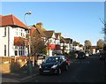
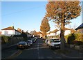
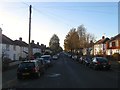
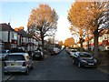
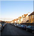
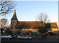
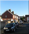
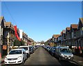
Photos of BN3 4ES

Area Information
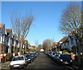
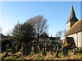
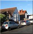
Living in BN3 4ES means inhabiting a small, tightly knit residential cluster on the western edge of Brighton and Hove. With a population of 1,853, this area is part of the historically significant Portslade district, known for its 19th-century railway station and industrial heritage. The community is predominantly middle-aged, with a median age of 47 and most residents falling within the 30-64 age range. Daily life here blends practicality with a touch of history, from the former Southdown Brewery site now housing Mersen UK to the quiet charm of St Nicolas Church, over 800 years old. Proximity to Portslade Railway Station and Shoreham Airport offers connectivity, while nearby shops like Tesco Portslade and Iceland Portslade cater to everyday needs. Though the area has faced post-1980 urban decline, its current residents benefit from a low flood risk and a network of local amenities. For buyers, BN3 4ES presents a compact, owner-occupied market with houses as the primary accommodation type, ideal for those seeking a stable, community-focused environment.
- Area Type
- Postcode
- Area Size
- Not available
- Population
- Not available
- Population Density
- Not available
The property market in BN3 4ES is characterised by a high rate of home ownership (61%) and a predominance of houses. This suggests a market skewed towards owner-occupiers rather than renters, with limited availability of apartments or flats. The small residential cluster means the housing stock is constrained, which could make the area competitive for buyers. Given the area’s proximity to Portslade’s historical core and nearby amenities like St Peter’s Community Primary School, properties here may appeal to those seeking a blend of practicality and local character. However, the lack of large-scale development or new builds implies limited scope for expansion. Buyers should consider the area’s compact size and the potential for limited property turnover. The focus on houses also means buyers may need to prioritise space and location over newer developments, with the existing stock reflecting the area’s industrial and residential evolution over the past two centuries.
House Prices in BN3 4ES
No properties found in this postcode.
Energy Efficiency in BN3 4ES
Life in BN3 4ES offers a mix of practical amenities and historical character. Nearby retail options include Tesco Portslade, Iceland Portslade, and M&S Hove BP, providing everyday shopping convenience. The area’s transport links, including multiple railway stations, make commuting straightforward, while proximity to Shoreham Airport caters to travel needs. For leisure, the historical landmarks of Portslade—such as St Nicolas Church and the former Southdown Brewery—add cultural depth to daily life. Parks and community spaces, like Easthill House and its adjacent park, offer green spaces for recreation. The area’s blend of retail, transport, and heritage creates a lifestyle that balances modern convenience with a sense of local identity. While the lack of large-scale leisure facilities may require residents to venture further for entertainment, the immediate vicinity provides sufficient amenities for everyday living.
Amenities
Schools
The nearest school to BN3 4ES is St Peter’s Community Primary School, a primary institution serving the local area. While no Ofsted rating is provided in the data, the presence of a primary school indicates the area’s suitability for families with young children. The absence of secondary schools or other educational institutions in the immediate vicinity means parents may need to look beyond BN3 4ES for secondary education options. This could be a consideration for families planning long-term residency, as the school mix suggests a focus on early education rather than comprehensive schooling. However, the proximity of Portslade’s historical core and nearby transport links may offset this limitation, offering access to broader educational resources in Brighton and Hove.
| Rank | School | Type | Entry gender | Ages |
|---|
Explore more schools in this area
Go to Schools tabDemographics
BN3 4ES has a median age of 47, with the majority of residents aged 30-64. This suggests a community of established adults, many of whom are likely in their prime working years. Home ownership is high at 61%, with houses being the dominant accommodation type. The predominant ethnic group is White, reflecting the area’s historical roots and limited recent demographic shifts. While no specific deprivation data is provided, the high home ownership rate and age profile indicate a stable, possibly middle-income population. The absence of detailed diversity metrics means the community’s broader ethnic composition remains unquantified. For families, the age range suggests a mix of professionals and older households, though the lack of data on younger demographics or children’s proportions means the area’s appeal to new parents is unclear. The focus on owner-occupied homes implies a long-term commitment to the area, with residents likely prioritising stability over transient living.
Household Size
Accommodation Type
Tenure
Ethnic Group
Religion
Household Composition
Age
Household Deprivation
NS-SEC
Explore more demographic insights in this area
Go to Demographics tabPlanning
Planning Constraints
- Flood RiskPremium
- Ramsar Wetland SitesPremium
- Area of Outstanding Natural BeautyPremium
- Protected Nature ReservePremium
- Protected WoodlandPremium