Area Overview for BN21 4HW
Photos of BN21 4HW

Area Information
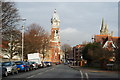
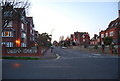
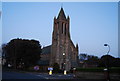
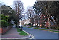
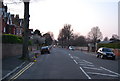
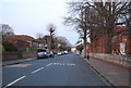
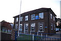
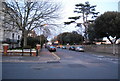
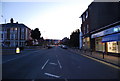
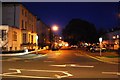
BN21 4HW is a small residential cluster in Meads, a coastal ward of Eastbourne, East Sussex. With a population of 1,993, it is a compact area where historic character meets modern convenience. Situated below the South Downs, the area retains its 19th-century roots, with many large Victorian and Edwardian homes converted into flats. The Meads Community Association, formed in 1990, has preserved the area’s unique identity, resisting unsympathetic development. Daily life here is shaped by its proximity to Eastbourne’s amenities, including independent schools, coastal walks, and historic sites like All Saints Church (1879) and Helen Garden (1935). The area’s charm lies in its mix of architectural heritage and community-driven preservation, offering a quiet, settled environment for those seeking a balance between history and practicality.
- Area Type
- Postcode
- Area Size
- Not available
- Population
- 1993
- Population Density
- 9010 people/km²
The property market in BN21 4HW is characterised by a low home ownership rate of 43%, suggesting that the area is more rental-focused than owner-occupied. The predominant accommodation type is flats, many of which are conversions of historic Victorian and Edwardian homes. This reflects the area’s heritage and limited space, as well as its appeal to renters seeking compact, well-maintained properties. Given the small size of the postcode and its integration with Meads’ conservation area, the housing stock is finite. Buyers should consider that this is not a typical owner-occupied market, with limited scope for new builds. For those seeking a home, the availability of flats in historic buildings may present both opportunities and constraints, depending on personal preferences and long-term goals.
House Prices in BN21 4HW
No properties found in this postcode.
Energy Efficiency in BN21 4HW
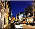
Living in BN21 4HW offers access to a range of amenities within practical reach. The area is served by five retail venues, including major supermarkets like Tesco Eastbourne, Co-op Eastbourne, and Morrisons Daily, ensuring everyday shopping needs are met. Parks and green spaces are abundant, with Helen Garden (a public park featuring treetop walks and sea views) and the Peace Garden (a WWII memorial site) providing recreational opportunities. The Meads Village Allotments, community-owned since 2019, add to the area’s appeal for those interested in gardening. The historic character of the area, combined with its proximity to Eastbourne’s coastal attractions and cultural sites, creates a lifestyle that balances heritage with modern convenience.
Amenities
Schools
The nearest school to BN21 4HW is Eastbourne College, an independent institution. While no Ofsted rating is provided, its status as an independent school suggests it may cater to a range of educational needs, though it is likely more focused on secondary education. The area’s proximity to Eastbourne’s broader school network, combined with its historic character, may appeal to families seeking a mix of traditional and modern educational options. However, the data does not include other schools in the immediate vicinity, so prospective buyers should investigate further for primary or state-funded alternatives. The presence of a single independent school highlights the area’s potential for families prioritising private education, though it may not cover all stages of schooling.
| Rank | School | Type | Entry gender | Ages |
|---|
Explore more schools in this area
Go to Schools tabDemographics
BN21 4HW has a median age of 47, with the majority of residents aged 30–64. This suggests a community of middle-aged and older adults, likely including professionals and families. Home ownership is relatively low at 43%, indicating that a significant portion of the population rents. The predominant accommodation type is flats, reflecting the area’s historic conversion of larger homes into smaller units. The predominant ethnic group is White, though specific diversity metrics are not provided. The age profile and home ownership rate suggest a stable, possibly transient population, with a focus on rental properties rather than long-term ownership. This dynamic may influence the local economy and social fabric, with a mix of long-term residents and temporary occupants.
Household Size
Accommodation Type
Tenure
Ethnic Group
Religion
Household Composition
Age
Household Deprivation
NS-SEC
Explore more demographic insights in this area
Go to Demographics tabPlanning
Planning Constraints
- Flood RiskPremium
- Ramsar Wetland SitesPremium
- Area of Outstanding Natural BeautyPremium
- Protected Nature ReservePremium
- Protected WoodlandPremium