Area Overview for BN2 7JU
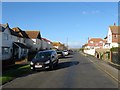
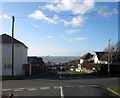
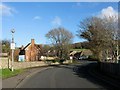
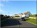
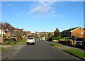
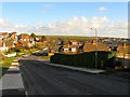
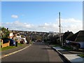
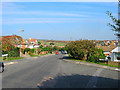
Photos of BN2 7JU
Area Information
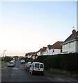
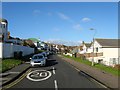
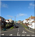
BN2 7JU lies in Rottingdean, a coastal village on Brighton and Hove’s south coast, 4 miles southeast of Brighton. With a population of 1,716 and a density of 1,192 people per square kilometre, it is a compact, residential cluster defined by its seaside charm and historic character. The village borders Saltdean, Ovingdean, and Woodingdean, and its appeal stems from a blend of heritage, natural beauty, and proximity to urban amenities. Rottingdean’s origins trace back to the Saxon era, with notable events including a 1377 raid during the Hundred Years’ War. Today, it retains a genteel, heritage-conscious atmosphere, with preservation societies actively safeguarding its landmarks. The area features a black wooden windmill on Beacon Hill, a Grade 2 listed building, and Kipling Gardens, once the estate of Rudyard Kipling. Its appeal lies in its picturesque duck ponds, cosy cottages, and a mix of historic and modern living, making it a sought-after spot for those seeking coastal tranquillity with easy access to Brighton’s vibrancy.
- Area Type
- Postcode
- Area Size
- Not available
- Population
- 1716
- Population Density
- 1192 people/km²
BN2 7JU is primarily an owner-occupied area, with 74% of homes owned by residents rather than rented. The accommodation type is predominantly houses, which contrasts with areas dominated by flats or apartments. This suggests a market geared towards families and professionals seeking spacious, private living. The high home ownership rate indicates a stable, long-term resident base, which can be appealing to buyers seeking investment potential. However, the area’s small size means the housing stock is limited, and buyers may need to consider nearby postcodes for more options. The presence of historic homes and landmarks, such as the Grade 2 windmill, adds unique character but may also influence property values. For those prioritising family-friendly, single-family homes, BN2 7JU offers a niche market with a distinct heritage appeal.
House Prices in BN2 7JU
No properties found in this postcode.
Energy Efficiency in BN2 7JU
BN2 7JU’s residents have access to a range of amenities within practical reach. Retail options include Tesco Rottingdean, Budgens Rottingdean, and Co-op Saltdean, providing everyday shopping convenience. The village’s character is defined by its historic cottages, duck ponds, and Beacon Hill, a local nature reserve. The Rottingdean Terraces, built in the 1930s, offer a prominent residential feature. Nearby, the Blackwood Windmill and Kipling Gardens add cultural and recreational value. The mix of retail, transport links, and natural spaces creates a balanced lifestyle, blending coastal charm with practicality. For those prioritising heritage and community, BN2 7JU offers a compact, accessible environment with a strong sense of place.
Amenities
Schools
The nearest school to BN2 7JU is St Aubyn’s School, an independent institution. No Ofsted rating is provided in the data, but its independent status suggests it may cater to students seeking private education. The area’s educational landscape includes Rottingdean Church of England Primary School, which opened in 1860 and relocated to Whiteway Lane in 1953. While no other schools are listed in the data, the presence of both a primary school and an independent secondary option indicates a range of educational choices for families. The mix of state and private schooling can be advantageous for parents seeking flexibility, though the specific quality of St Aubyn’s remains unquantified.
| Rank | School | Type | Entry gender | Ages |
|---|
Explore more schools in this area
Go to Schools tabDemographics
BN2 7JU’s population skews towards adults aged 30–64, with a median age of 47. This suggests a community of established professionals and families, rather than students or retirees. Home ownership is high at 74%, indicating a stable, long-term resident base. The area is predominantly occupied by houses, reflecting a preference for single-family living over flats or apartments. The predominant ethnic group is White, though specific data on diversity or deprivation is not provided. The age profile and ownership rates suggest a mature, settled population with a focus on residential stability. The absence of data on deprivation means no conclusions can be drawn about socioeconomic challenges, but the high home ownership and low crime risk (75/100) imply a relatively secure, middle-to-upper-income demographic.
Household Size
Accommodation Type
Tenure
Ethnic Group
Religion
Household Composition
Age
Household Deprivation
NS-SEC
Explore more demographic insights in this area
Go to Demographics tabPlanning
Planning Constraints
- Flood RiskPremium
- Ramsar Wetland SitesPremium
- Area of Outstanding Natural BeautyPremium
- Protected Nature ReservePremium
- Protected WoodlandPremium