Area Overview for BN2 4GR
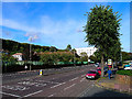
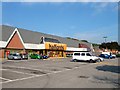
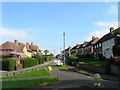
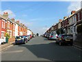
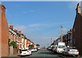
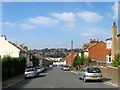
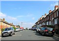
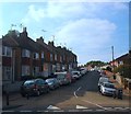
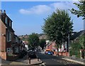
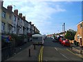
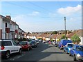
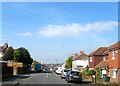
Photos of BN2 4GR
Area Information
BN2 4GR is a small, densely populated residential area in Brighton & Hove, England, with a population of 1,631 people spread across 680 people per square kilometre. It lies within the Hollingdean & Fiveways ward, a historically significant part of the city characterised by late 19th- and early 20th-century terraced housing, 1950s estates, and a mix of council properties and low-rise flats. The area is bounded by major roads such as Lewes Road and Ditchling Road, placing it near the city’s core. Daily life here balances urban convenience with a residential feel, with easy access to rail networks and local amenities. The postcode covers a compact cluster of homes, many of which are flats, reflecting the area’s housing stock. Its proximity to Brighton’s cultural and economic hubs, combined with its compact size, makes it appealing for those seeking a blend of convenience and community. However, its small scale means the area’s character is defined by its immediate surroundings, with limited expansion beyond its boundaries.
- Area Type
- Postcode
- Area Size
- Not available
- Population
- 1631
- Population Density
- 680 people/km²
The property market in BN2 4GR is characterised by a high proportion of rental properties, with only 19% of residents owning their homes. The area’s housing stock is dominated by flats, reflecting its urban, compact layout. This suggests that the area is not a traditional owner-occupied neighbourhood but rather a rental-focused zone, likely attracting professionals or students seeking short-term or flexible housing. The prevalence of flats also indicates limited scope for larger family homes, which may be a consideration for buyers prioritising space. Given the small size of the postcode, the immediate surrounding areas may offer more varied housing options, but BN2 4GR itself is unlikely to cater to those seeking detached properties. For buyers, the area’s affordability and proximity to transport links could be advantages, though the rental-heavy market may limit long-term equity growth.
House Prices in BN2 4GR
No properties found in this postcode.
Energy Efficiency in BN2 4GR
BN2 4GR offers a range of amenities within easy reach, including retail options such as Morrisons Daily, Aldi Moulsecoomb, and M&S University Brighton BP. These stores provide essential shopping and dining choices, supporting daily convenience. The area also includes the Fiveways pub, a notable local landmark with historical significance. While the data does not list parks or leisure facilities explicitly, the proximity to Brighton’s urban core suggests access to larger recreational spaces. The mix of retail and social venues contributes to a functional lifestyle, though the area’s small size means it relies on nearby neighbourhoods for more extensive leisure opportunities. The presence of a pub and multiple shops indicates a community-oriented environment, ideal for those valuing convenience over sprawling amenities.
Amenities
Schools
The nearest school to BN2 4GR is Homewood College, a special school serving students with specific educational needs. No other schools are listed in the data, meaning families with children requiring mainstream education may need to look beyond the immediate area. The presence of a special school indicates that the area is well-served for those with particular learning requirements, but it does not provide a comprehensive range of educational options. Parents seeking a broader selection of schools, including primary or secondary institutions, would need to consider nearby wards or commute to larger areas of Brighton & Hove. This limitation should be weighed against the convenience of other amenities within BN2 4GR.
| Rank | School | Type | Entry gender | Ages |
|---|
Explore more schools in this area
Go to Schools tabDemographics
The population of BN2 4GR has a median age of 47, with the majority of residents aged between 30 and 64. This suggests a community skewed towards middle-aged adults, likely including professionals and families. Home ownership is low, with only 19% of residents owning their homes, indicating that the area is predominantly a rental market. The primary accommodation type is flats, which aligns with the compact nature of the postcode. The predominant ethnic group is White, though specific data on diversity is not provided. The age profile and housing data suggest a stable, long-term resident base, with limited turnover. The lack of high deprivation indicators implies that quality of life is generally maintained, though the low home ownership rate may affect long-term investment potential.
Household Size
Accommodation Type
Tenure
Ethnic Group
Religion
Household Composition
Age
Household Deprivation
NS-SEC
Explore more demographic insights in this area
Go to Demographics tabPlanning
Planning Constraints
- Flood RiskPremium
- Ramsar Wetland SitesPremium
- Area of Outstanding Natural BeautyPremium
- Protected Nature ReservePremium
- Protected WoodlandPremium