Area Overview for BN2 3QJ
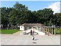
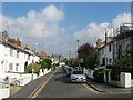
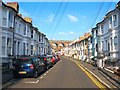
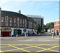
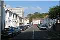
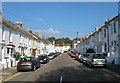
Photos of BN2 3QJ


Area Information
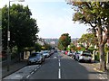
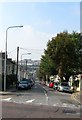
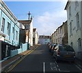
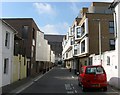
BN2 3QJ is a small residential postcode cluster nestled in Brighton and Hove, England, with a population of 1,960. Situated on the northern slopes of the South Downs, it reflects Brighton’s northward expansion from the historic town centre. The area is defined by its Victorian and early 20th-century housing stock, conservation area status, and a structured suburban layout. Originally rural farmland, it evolved into a residential district from the 1820s, with developments like Round Hill Crescent (1865) and semi-detached villas along London Road. Today, it retains a mix of terraced and semi-detached properties, blending historical character with modern living. Proximity to London Road Railway Station and nearby retail hubs like Sainsburys Lewes and M&S University Brighton BP ensures convenience. The area’s conservation status protects its architectural heritage, while its location offers easy access to Brighton’s cultural and educational offerings. For buyers, BN2 3QJ presents a blend of period charm and practicality, ideal for those seeking a compact, historic suburb with strong transport links.
- Area Type
- Postcode
- Area Size
- Not available
- Population
- 1960
- Population Density
- 20103 people/km²
The property market in BN2 3QJ is characterised by a 34% home ownership rate, suggesting that most properties are rented rather than owner-occupied. The predominant accommodation type is flats, reflecting a housing stock suited to smaller households or students. This dynamic implies limited availability of larger, family-friendly homes, which may be a consideration for buyers seeking long-term residency. The area’s conservation status adds value through historic appeal but may restrict modernisation or expansion. Given the small postcode area, property options are likely concentrated in nearby clusters, with proximity to Brighton’s amenities a key selling point. Buyers should weigh the trade-off between period character and practicality, particularly if prioritising space or investment potential. The rental market’s dominance may also influence property prices, with potential for appreciation linked to Brighton’s broader real estate trends.
House Prices in BN2 3QJ
No properties found in this postcode.
Energy Efficiency in BN2 3QJ
Living in BN2 3QJ offers a blend of convenience and suburban tranquillity. Nearby retail options include Sainsburys Lewes, M&S University Brighton BP, and Co-op Lewes, providing essential shopping within practical reach. The area’s rail connectivity is a standout feature, with London Road, Moulsecoomb, and Preston Park stations enabling swift travel to Brighton’s vibrant core or further afield. While the data does not specify parks or leisure facilities, the historical context of the South Downs suggests nearby green spaces for recreation. The mix of retail and transport infrastructure supports a lifestyle that balances daily needs with ease of movement. For residents, the area’s proximity to Brighton’s amenities—such as universities, cultural venues, and employment hubs—enhances its appeal. However, the absence of detailed information on leisure options means buyers should investigate local parks or community centres independently.
Amenities
Schools
| Rank | School | Type | Entry gender | Ages |
|---|
Explore more schools in this area
Go to Schools tabDemographics
BN2 3QJ has a median age of 22, with the majority of residents aged 15–29. This reflects a young adult demographic, likely drawn to the area’s proximity to educational institutions and employment opportunities. Home ownership here is relatively low at 34%, suggesting a rental market dominance. The accommodation type is predominantly flats, indicating a mix of student housing and smaller family units. The predominant ethnic group is White, though specific diversity metrics are not provided. The youth-centric profile means the area is likely vibrant with social activity, though it may lack the services typically found in more established communities. Low home ownership could imply transient populations, which may affect community cohesion. Buyers should consider whether this demographic aligns with their long-term needs, particularly if seeking a stable, family-oriented environment.
Household Size
Accommodation Type
Tenure
Ethnic Group
Religion
Household Composition
Age
Household Deprivation
NS-SEC
Explore more demographic insights in this area
Go to Demographics tabPlanning
Planning Constraints
- Flood RiskPremium
- Ramsar Wetland SitesPremium
- Area of Outstanding Natural BeautyPremium
- Protected Nature ReservePremium
- Protected WoodlandPremium