Area Overview for BN2 3NE
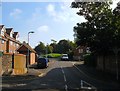
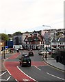
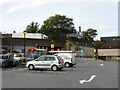
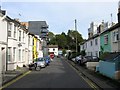
Photos of BN2 3NE
Area Information
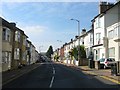
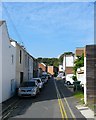
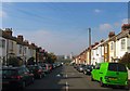
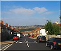
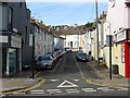
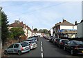
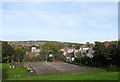
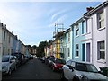
BN2 3NE is a small residential cluster in Brighton, England, with a population of 1770. Situated on a steep hill northeast of the city centre, it lies within the Hanover & Elm Grove electoral ward, bounded by roads like Lewes Road. The area blends densely packed terraced houses with interwar semi-detached council housing, reflecting its historical development from the 1850s. Notable landmarks include the Royal Sussex County Hospital, once an Elm Grove workhouse, and two listed churches. Daily life here is shaped by its proximity to Brighton’s core, with easy access to rail links and local amenities. The steep terrain influences the layout, creating a compact, walkable neighbourhood. Residents benefit from a mix of housing styles, from older terraces to newer council properties, and a community rooted in historical working-class development. The area’s character is defined by its mix of residential density and pockets of varied housing, offering a distinct slice of Brighton’s urban fabric.
- Area Type
- Postcode
- Area Size
- Not available
- Population
- 1770
- Population Density
- 18971 people/km²
BN2 3NE is a predominantly owner-occupied area, with 46% of homes owned by residents, though the remaining 54% are likely rental properties. The accommodation type is primarily houses, which suggests a focus on family homes and larger properties compared to flats or apartments. This mix of ownership and rental housing may appeal to both long-term residents and those seeking affordable accommodation in Brighton. The area’s small size means the housing stock is limited, but its proximity to the city centre and rail links could make it attractive for buyers seeking a balance between urban convenience and residential tranquillity. The prevalence of houses, including interwar semi-detached council housing, indicates a range of property styles, though specific details on property sizes or price ranges are not available. Buyers should consider the compact nature of the area and its potential for limited new developments.
House Prices in BN2 3NE
No properties found in this postcode.
Energy Efficiency in BN2 3NE
BN2 3NE offers a range of nearby amenities within practical reach. Retail options include Co-op Lewes, Sainsburys Lewes, and M&S University Brighton BP, providing everyday shopping convenience. The area’s steep hill location is complemented by its accessibility to rail stations, which connect residents to broader networks. While specific parks or leisure facilities are not detailed in the data, the presence of small shops and public buildings suggests a community-oriented environment. The mix of housing styles and historical features, such as listed churches and the Royal Sussex County Hospital, adds character to daily life. The compact nature of the area means amenities are concentrated, reducing the need for long journeys. Residents can enjoy a blend of urban convenience and local distinctiveness, with a focus on practicality and proximity to essential services.
Amenities
Schools
BN2 3NE is served by two primary schools: Fairlight Junior School and Fairlight Infant School. Both are primary institutions, catering to younger children and providing foundational education for families in the area. The presence of two primary schools within proximity suggests a focus on early education, though no secondary schools are listed in the data. For families with children, this mix of primary schools offers convenience, reducing the need for long commutes. However, the absence of secondary school data means parents may need to look further afield for secondary education. The schools’ specific Ofsted ratings are not provided, so their performance cannot be assessed here. Nonetheless, the availability of two primary schools supports the area’s appeal to families seeking a stable educational environment.
| Rank | School | Type | Entry gender | Ages |
|---|
Explore more schools in this area
Go to Schools tabDemographics
BN2 3NE has a median age of 22, though the most common age range is adults aged 30–64, indicating a stable population of working-age individuals and families. Home ownership stands at 46%, suggesting a balance between owner-occupied properties and rental housing. The area is predominantly composed of houses, with no data on flats or apartments. The predominant ethnic group is White, though specific diversity metrics are not provided. The low median age contrasts with the adult demographic, hinting at a mix of young professionals and families. With a population of 1770, the community is small but concentrated, likely fostering a close-knit environment. The lack of detailed deprivation data means quality of life factors like access to services or employment opportunities are not quantified here, but the presence of schools and transport links implies reasonable infrastructure for residents.
Household Size
Accommodation Type
Tenure
Ethnic Group
Religion
Household Composition
Age
Household Deprivation
NS-SEC
Explore more demographic insights in this area
Go to Demographics tabPlanning
Planning Constraints
- Flood RiskPremium
- Ramsar Wetland SitesPremium
- Area of Outstanding Natural BeautyPremium
- Protected Nature ReservePremium
- Protected WoodlandPremium