Area Overview for BN15 9LX
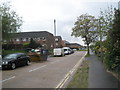
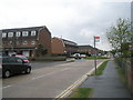
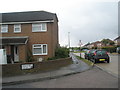
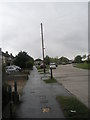
Photos of BN15 9LX
Area Information
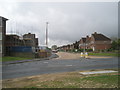
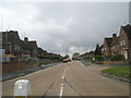
BN15 9LX is a small residential postcode cluster in West Sussex, nestled within the coastal village of Lancing. This area, covering just 348 square metres, is densely populated, with 1,375 residents packed into a space that sees 3.95 million people per square kilometre. Despite its compact size, it sits at the heart of a historically rich region. Lancing, the village it belongs to, has Saxon roots dating to the 6th century, with ancient field boundaries preserved on the South Downs. Today, it is a suburban community within the Brighton/Worthing/Littlehampton conurbation, blending historical charm with modern convenience. The area’s proximity to the River Adur and its connections to nearby towns via rail and road make it a practical choice for those seeking a balance between coastal living and urban accessibility. Residents benefit from nearby independent schools, a network of railway stations, and two airports within reach. The high broadband score of 100 ensures seamless digital connectivity, while the low crime risk score of 75 underscores a safe, stable environment. This postcode is ideal for those prioritising security, community cohesion, and easy access to amenities.
- Area Type
- Postcode
- Area Size
- 348 m²
- Population
- Not available
- Population Density
- Not available
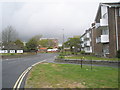
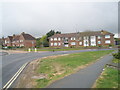
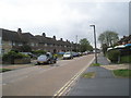
The property market in BN15 9LX is characterised by high home ownership (80%) and a predominance of houses. This indicates a community where owner-occupation is the norm, rather than rental or leasehold properties. The focus on houses, rather than flats or apartments, suggests a suburban, family-friendly environment with larger living spaces. Given the area’s small size and high population density, the housing stock is likely limited, with properties concentrated in a compact cluster. Buyers should consider that the market may be competitive, with limited new developments due to the area’s established nature. The high home ownership rate also implies that properties are likely to retain value, as they are held by long-term residents. For those seeking a stable, low-risk investment, BN15 9LX offers a mix of traditional housing and proximity to essential amenities, though the small footprint means buyers must act swiftly to secure available properties.
House Prices in BN15 9LX
No properties found in this postcode.
Energy Efficiency in BN15 9LX
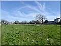
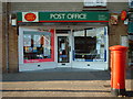
Living in BN15 9LX offers access to a range of amenities within walking or short driving distance. Retail options include Co-op Lancing, Asda Lancing, and Budgens South, providing essential shopping and grocery needs. The area’s railway stations connect residents to broader networks, while nearby airports offer travel convenience. The village’s historical character is complemented by its suburban practicality, with a mix of green spaces and community facilities. While specific parks or leisure venues are not detailed in the data, the proximity to the River Adur and the preserved South Downs landscape suggests opportunities for outdoor activities. The presence of multiple independent schools and a focus on family-oriented living creates a community feel that balances tradition with modern comforts. Residents benefit from a compact, well-connected environment that supports both daily necessities and a sense of local identity.
Amenities
Schools
BN15 9LX is served by three independent schools: Ardmore School, Lancing Montessori Centre and Ardmore School, and Ardmore Montessori School. All three are private institutions, offering alternative educational pathways outside the state system. The presence of multiple independent schools suggests a demand for private education, likely driven by the area’s family demographic. While no Ofsted ratings are provided, the concentration of independent schools indicates a community that prioritises choice in education. Families seeking a non-traditional curriculum or smaller class sizes may find these options appealing. However, the absence of state schools means residents must consider the financial commitment of private education. For those valuing flexibility in schooling, the variety of independent options in the area is a notable advantage.
| Rank | School | Type | Entry gender | Ages |
|---|
Explore more schools in this area
Go to Schools tabDemographics
BN15 9LX has a median age of 47, with the majority of residents aged between 30 and 64. This suggests a community of established professionals and families, rather than a transient population. Home ownership is high, at 80%, indicating a strong presence of long-term residents. The accommodation type is predominantly houses, reflecting a suburban rather than a high-density urban setting. The predominant ethnic group is White, which aligns with the broader demographic trends in the Adur district. The age profile and home ownership rate imply a stable, low-turnover community where residents are likely to remain for extended periods. The absence of specific data on deprivation or diversity means the area’s social dynamics are not fully quantified, but the high home ownership and mature age range suggest a cohesive, settled population. For buyers, this signals a market with established property values and a focus on family-oriented living.
Household Size
Accommodation Type
Tenure
Ethnic Group
Religion
Household Composition
Age
Household Deprivation
NS-SEC
Explore more demographic insights in this area
Go to Demographics tabPlanning
Planning Constraints
- Flood RiskPremium
- Ramsar Wetland SitesPremium
- Area of Outstanding Natural BeautyPremium
- Protected Nature ReservePremium
- Protected WoodlandPremium