Area Overview for BN14 7HB
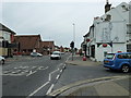
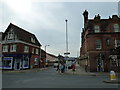
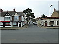
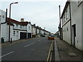
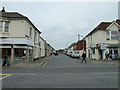
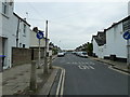
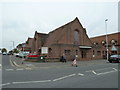
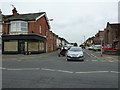
Photos of BN14 7HB
Area Information
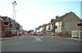
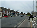
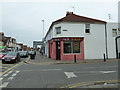
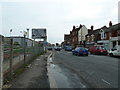
BN14 7HB is a small residential postcode area in England, nestled within the broader Worthing local government area. With a population of just 1,586, it reflects a tight-knit community characterised by a predominance of owner-occupied homes. The area’s compact size means daily life is shaped by proximity to local amenities, including multiple railway stations and retail outlets. Residents benefit from easy access to Worthing’s urban core, where services and transport links converge. The postcode falls within the East Worthing and Shoreham constituency, a region known for its coastal proximity and historical ties to the South East. While the area lacks large-scale infrastructure, its small footprint fosters a quiet, stable environment. The median age of 47 suggests a mature demographic, with a strong presence of adults aged 30–64. For those seeking a low-maintenance lifestyle with reliable connectivity and minimal environmental constraints, BN14 7HB offers a straightforward proposition.
- Area Type
- Postcode
- Area Size
- Not available
- Population
- 1586
- Population Density
- 5118 people/km²
BN14 7HB is predominantly an owner-occupied area, with 86% of homes owned by residents rather than rented. The accommodation type is primarily houses, which suggests a mix of detached, semi-detached, or terraced properties typical of suburban or semi-rural settings. This composition indicates a market where property values may be more stable compared to areas with higher rental demand. For buyers, the focus on owner-occupation means fewer opportunities for short-term investment, but it also implies a community of residents with a long-term interest in the area. The small size of the postcode area means the housing stock is limited, so buyers should consider nearby postcodes for broader options. The lack of flats or apartments further reinforces the area’s appeal to those seeking traditional family homes.
House Prices in BN14 7HB
No properties found in this postcode.
Energy Efficiency in BN14 7HB
Residents of BN14 7HB have access to a range of amenities within practical reach. Retail options include Co-op Worthing, Tesco Worthing South, and Tesco Salvington, providing everyday shopping needs. The area’s rail network connects to multiple stations, facilitating travel to nearby urban centres. Airports like Shoreham Airport and Shoreham Brighton City Airport are also nearby, offering regional and national flight connections. While the data does not mention parks or leisure facilities, the proximity to Worthing suggests access to larger recreational spaces. The presence of multiple retail outlets and transport links contributes to a convenient lifestyle, balancing local convenience with regional accessibility.
Amenities
Schools
The nearest schools to BN14 7HB include Worthing High School, which operates as both a primary school and an academy with a good Ofsted rating. This dual role means the school serves multiple age groups, offering convenience for families with children at different stages of education. The academy’s good rating suggests a reliable standard of teaching and facilities. However, the data does not specify the number of students or additional schools in the immediate vicinity. For families, the presence of a single school with a strong rating is a key consideration, though it may limit options for those seeking alternative educational providers. The proximity of Worthing High School to the area reinforces its role as a central hub for local education.
| Rank | School | Type | Entry gender | Ages |
|---|
Explore more schools in this area
Go to Schools tabDemographics
The population of BN14 7HB is 1,586, with a median age of 47, indicating a mature community. The most common age group is adults aged 30–64, reflecting a stable, established demographic. Home ownership is high at 86%, suggesting a strong presence of long-term residents. The area is predominantly composed of houses, which aligns with the higher proportion of owner-occupied properties. The predominant ethnic group is White, though no specific data on diversity or deprivation is provided. This demographic profile implies a community focused on stability and family-oriented living. The absence of younger or older age groups may mean fewer childcare needs or retirement-focused amenities, which could influence local service provision. The high home ownership rate also suggests a lower turnover of properties, contributing to a sense of continuity in the area.
Household Size
Accommodation Type
Tenure
Ethnic Group
Religion
Household Composition
Age
Household Deprivation
NS-SEC
Explore more demographic insights in this area
Go to Demographics tabPlanning
Planning Constraints
- Flood RiskPremium
- Ramsar Wetland SitesPremium
- Area of Outstanding Natural BeautyPremium
- Protected Nature ReservePremium
- Protected WoodlandPremium