Area Overview for BN13 3RT
Photos of BN13 3RT
46 photos from this area
Area Information
Key information about the BN13 3RT including its size, population, and administrative classification.
- Area Type
- Postcode
- Area Size
- 21.0 hectares
- Population
- 1877
- Population Density
- 855 people/km²
House Prices in BN13 3RT
8
Properties
£226,583
Average Sold Price
£58,750
Lowest Price
£560,000
Highest Price
Showing 8 properties
| Address | Type | Beds | Baths | Last Sale Price | Last Sale Date | |
|---|---|---|---|---|---|---|
| Flint Cottage, Titnore Lane, Northbrook, Worthing, BN13 3RT | Detached | 3 | 1 | £560,000 | Jan 2019 | |
| 1, Nursery Cottages, Titnore Way, Northbrook, Worthing, BN13 3RT | house | - | - | £61,000 | Aug 1995 | |
| 2, Nursery Cottages, Titnore Way, Northbrook, Worthing, BN13 3RT | house | - | - | £58,750 | Jul 1995 | |
| Two Shoes, West Worthing Club, Titnore Way, Northbrook, Worthing, BN13 3RT | Bungalow | 3 | - | - | - | |
| Northbrook Farm Caravan Park, Titnore Way, Northbrook, Worthing, BN13 3RT | commercial | - | - | - | - | |
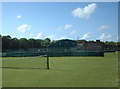
| Tennis 61M From West Worthing Club, Titnore Way 27M From Unnamed Road, Titnore Lane, Northbrook, Worthing, BN13 3RT | Leisure | - | - | - | - | |
| Tennis 76M From West Worthing Club, Titnore Way 27M From Unnamed Road, Titnore Lane, Northbrook, Worthing, BN13 3RT | Leisure | - | - | - | - | |
| Tennis 29M From West Worthing Club, Titnore Way 55M From Unnamed Road, Titnore Lane, Northbrook, Worthing, BN13 3RT | Leisure | - | - | - | - |
Energy Efficiency in BN13 3RT
Amenities
Schools
| Rank | School | Type | Entry gender | Ages |
|---|
Explore more schools in this area
Go to Schools tabDemographics
Household Size
Family (3-5 people)
most common
Accommodation Type
Houses
most common
Tenure
74
majority
Ethnic Group
White
most common
Religion
N/A
most common
Household Composition
N/A
most common
Age
47
median
Adults (30-64 years)
most common
Household Deprivation
N/A
with no deprivation
NS-SEC
42
in Lower managerial occupations
Explore more demographic insights in this area
Go to Demographics tabPlanning
Planning Constraints
- Flood RiskPremium
- Ramsar Wetland SitesPremium
- Area of Outstanding Natural BeautyPremium
- Protected Nature ReservePremium
- Protected WoodlandPremium