Area Overview for BN13 3JJ
Photos of BN13 3JJ
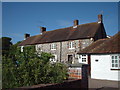
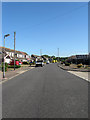
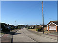
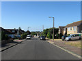
27 photos from this area
Area Information
Key information about the BN13 3JJ including its size, population, and administrative classification.
- Area Type
- Postcode
- Area Size
- 4612 m²
- Population
- Not available
- Population Density
- Not available
House Prices in BN13 3JJ
8
Properties
£215,357
Average Sold Price
£60,000
Lowest Price
£328,000
Highest Price
Showing 8 properties
| Address | Type | Beds | Baths | Last Sale Price | Last Sale Date | |
|---|---|---|---|---|---|---|
| 72 New Road, Durrington, Worthing, BN13 3JJ | Bungalow | - | - | £328,000 | Feb 2022 | |
| 70 New Road, Durrington, Worthing, BN13 3JJ | Bungalow | 2 | - | £272,000 | Oct 2017 | |
| 64 New Road, Durrington, Worthing, BN13 3JJ | Bungalow | 2 | 1 | £275,000 | Feb 2017 | |
| 74 New Road, Durrington, Worthing, BN13 3JJ | Semi-detached | 2 | - | £255,000 | Jan 2017 | |
| 66 New Road, Durrington, Worthing, BN13 3JJ | Bungalow | 2 | 1 | £245,000 | May 2015 | |
| 68 New Road, Durrington, Worthing, BN13 3JJ | Detached | 2 | 1 | £72,500 | Jan 1999 | |
| 76 New Road, Durrington, Worthing, BN13 3JJ | Detached | - | - | £60,000 | Mar 1995 | |
| 62 New Road, Durrington, Worthing, BN13 3JJ | Detached | - | - | - | - |
Energy Efficiency in BN13 3JJ
Amenities
Schools
| Rank | School | Type | Entry gender | Ages |
|---|
Explore more schools in this area
Go to Schools tabDemographics
Household Size
Two person
most common
Accommodation Type
Houses
most common
Tenure
93
majority
Ethnic Group
White
most common
Religion
N/A
most common
Household Composition
N/A
most common
Age
47
median
Adults (30-64 years)
most common
Household Deprivation
N/A
with no deprivation
NS-SEC
35
in Lower managerial occupations
Explore more demographic insights in this area
Go to Demographics tabPlanning
Planning Constraints
- Flood RiskPremium
- Ramsar Wetland SitesPremium
- Area of Outstanding Natural BeautyPremium
- Protected Nature ReservePremium
- Protected WoodlandPremium