Area Overview for BN12 5FA
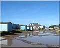
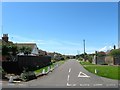
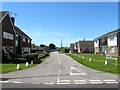
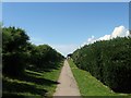
Photos of BN12 5FA

Area Information
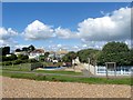
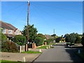
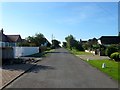
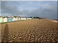
Living in Ferring offers a distinctly rural coastal experience within a few miles of Worthing. This specific postcode cluster serves a small residential population of 1553 people, creating a quiet atmosphere that differs significantly from the busy urban centres nearby. The area lies on the A259 road and traces its origins back to ancient Saxon settlements, retaining a deep historical connection to the landscape. Unlike many modern suburbs, BN12 5FA maintains an intimate scale defined by its history as a farming community that later absorbed holiday homes from the 1920s. You will find that daily life here is characterised by proximity to natural features like Highdown Hill and the historic St Andrew's parish church, rather than commercial high streets. The location provides a traditional village feel despite being part of the built-up area of Worthing. Residents benefit from a settled environment where the pace of life remains slow. The presence of the A259 ensures access to wider road networks, while the absence of large motorways keeps noise levels manageable. This postcode represents a specific choice for those who prioritise tranquillity and historical charm over urban convenience. The blend of ancient tree lines, open meadows, and suburban elements creates a生活环境 that feels preserved rather than developed.
- Area Type
- Postcode
- Area Size
- Not available
- Population
- Not available
- Population Density
- Not available
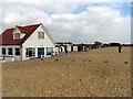
The housing stock in BN12 5FA is defined by traditional houses rather than flats or modern estates. With home ownership at 88%, this area functions almost entirely as an owner-occupied market rather than a rental hub. Buyers looking at homes in this postcode can expect to deal with a stock that has deep historical roots, dating back to the 17th and 18th centuries. The predominance of houses over flats aligns with the request for large accommodation suitable for retirement living. This is not a area where you will find purpose-built high-rises or council housing estates. Instead, the properties are likely detached or semi-detached dwellings typical of a farming village that expanded in the 1920s. The high percentage of homeowners indicates that homes are often sold through families moving down from larger properties or succession within extended families. This market dynamic means that selling a home here may take longer than in more transient urban areas. However, for those who find a property, it usually offers significant character and space. The lack of rental比重 suggests that the area is not a popular choice for speculation or buy-to-let strategies. Prices will reflect the historical nature of the buildings and the prestige of owning a piece of Ferring's history.
House Prices in BN12 5FA
No properties found in this postcode.
Energy Efficiency in BN12 5FA
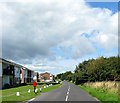
Your daily life in BN12 5FA revolves around a selection of accessible retail outlets and local transport hubs. While the village lacks a traditional high street, you have practical access to several supermarkets including The Southern Co-operative Co, Asda Ferring, and Tesco Goring. These venues provide groceries and essential household goods within a short drive or walk depending on your specific location within the parish. Transport connectivity focuses on rail stations in nearby Goring, Durrington, and Angmering, giving you five key rail options to reach major cities. The village also features small-scale retail facilities that serve the daily needs of its 1553 residents. You will find that leisure activities are centred around outdoor pursuits rather than cinemas or large gyms. The nearby Highdown Hill offers historical sites like Bronze Age forts and a Saxon cemetery, providing free access to nature and history. The Ferring Rife runs through the area, adding to the rural character. Dining and socialising often take place in the village hall or at local farming events. The A259 road ensures you can reach Worthing for wider entertainment options if you choose to leave the immediate vicinity. This lifestyle trades urban variety for historical immersion and coastal proximity.
Amenities
Schools
| Rank | School | Type | Entry gender | Ages |
|---|
Explore more schools in this area
Go to Schools tabDemographics
The community within this postcode is overwhelmingly dominated by older residents. You will see that the median age stands at 70 years, reflecting a population primarily consisting of elderly individuals aged 65 and over. Home ownership is extremely high at 88%, indicating that the vast majority of people have secured their houses within this specific area. This high ownership rate suggests long-term roots and stability rather than a transient tourist population. When you look at the accommodation type, the data confirms that houses predominate over other building styles, fitting the historical profile of a village settlement. The predominant ethnic group in the area is White, aligning with the traditional demographic makeup of this part of West Sussex. There is no significant young family demographic driving the housing market here. This demographic profile means the local shops and services cater largely to established households. The low rental stock correlates with the high ownership figures, making the area less focused on student landlords or short-term lets. If you are looking to buy a home here, you are entering a market of established owners who have likely lived in their properties for decades. This stability often translates to well-maintained buildings and a cohesive community structure centred around the local parish council.
Household Size
Accommodation Type
Tenure
Ethnic Group
Religion
Household Composition
Age
Household Deprivation
NS-SEC
Explore more demographic insights in this area
Go to Demographics tabPlanning
Planning Constraints
- Flood RiskPremium
- Ramsar Wetland SitesPremium
- Area of Outstanding Natural BeautyPremium
- Protected Nature ReservePremium
- Protected WoodlandPremium