Area Overview for BN11 2RT
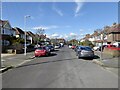
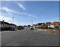
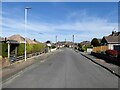
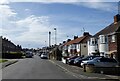
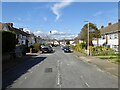
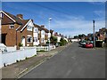
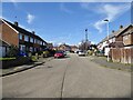
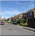
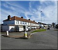
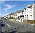
Photos of BN11 2RT


Area Information
Living in BN11 2RT means residing in a small residential cluster defined by the postcode, covering an area of 2,107 square metres. This specific location sits within the East Worthing residential zone, immediately east of the town centre in the borough of Worthing, West Sussex. The neighbourhood hosts a population of 1,618 people, creating a relatively intimate community setting compared to larger urban districts. You are situated in a part of Selden, an electoral ward that captures the essence of suburban living close to a major coastal town. The density here reaches a figure of 768,046 people per square kilometre when calculated strictly within the postcode boundaries, though this reflects statistical aggregation across the small cluster rather than overcrowding. Daily life in BN11 2RT is characterised by proximity to essential services and the quiet security of a contained residential designation. The area functions as a practical extension of Worthing, offering residents direct access to the amenities of the main town while maintaining distinct local identity. The coordinates place you approximately at 50.8151° N, -0.3615° W, a precise location that anchors the postcode within the wider district infrastructure. Whether you are commuting from the nearby station or enjoying the local environment, the setting combines the benefits of established suburbia with the convenience of living just a few miles from the sea. This specific patch of West Sussex offers a grounded, community-focused environment where the scale of the housing stock matches the population size, ensuring a manageable and stable neighbourhood for long-term living.
- Area Type
- Postcode
- Area Size
- 2107 m²
- Population
- 1618
- Population Density
- 3811 people/km²
The property market in BN11 2RT reflects a traditional, owner-led environment with very few rental properties. This distinction is clear from the data, which shows that 69% of homes are owner-occupied. Consequently, the market here is driven by buyers rather than landlords or investors looking for short-term lets. The accommodation type is exclusively houses, meaning you are looking at a housing stock of detached or semi-detached properties built for families rather than blocks of flats or commercial conversions. When buying homes in BN11 2RT, you are entering a market where sellers are likely to be current owners seeking to move, sell due to change of circumstances, or downsize. This dynamic often provides more negotiation flexibility compared to high-demand auction markets or areas dominated by first-time buyer rentals. The nature of the housing stock limits options to specific styles of residential property, primarily affecting the size and layout of living spaces you can acquire. The 69% ownership rate indicates a low turnover of rental listings, reinforcing the stability of the local market. For those seeking a property in BN11 2RT, the focus remains on purchasing standalone homes that suit the established needs of the local adult population. The market lacks the transient energy of university towns or areas with high student populations, offering a steadier, more predictable purchasing experience.
House Prices in BN11 2RT
No properties found in this postcode.
Energy Efficiency in BN11 2RT
Living in BN11 2RT offers convenient access to a selection of retail and transport hubs just within practical reach. For your daily shopping needs, five retail venues are available nearby, including Budgens MRH, Co-op Ham, and Tesco Dolphin. These supermarkets provide everything from fresh groceries to household essentials, ensuring you do not need to travel far for basic supplies. The presence of multiple major supermarket chains enhances the convenience of living in this residential cluster, allowing you to shop locally without venturing into the city centre. Rail transport is equally accessible, with five railway stations listed as nearby amenities: East Worthing Railway Station, Lancing Railway Station, and Worthing Railway Station. These stations facilitate easy commutes to Brighton, London, and the South Coast, integrating the area into the wider transport network. For leisure and travel, two airports are within reach: Shoreham Airport and Shoreham Brighton City Airport. This proximity offers flexible travel options for holidays or business trips. Your lifestyle in BN11 2RT blends suburban convenience with the connectivity of a major transport corridor. The specific availability of Tesco Dolphin and other local retailers means your week runs smoothly, balanced between daily errands and the broader opportunities provided by nearby rail and air links.
Amenities
Schools
Families considering BN11 2RT have access to two specific schools listed within the immediate vicinity, both catering to primary education. The first is Lyndhurst Infant School, a primary institution serving the younger age groups in the local catchment area. The second option is Davison Church of England High School for Girls, Worthing, which holds an outstanding Ofsted rating. This designation places the school in the top category for quality and performance, offering a high standard of education for families residing in the postcode. The mix of schools available is limited to these two primary institutions, meaning residents rely on this specific set of educational providers for their children's early education. The presence of a church of England high school with an outstanding rating is a significant positive factor for those prioritising academic excellence and faith-based education. You do not have a choice of secondary schools listed directly in the nearby schools data, suggesting the primary focus of the immediate environment is on infant and junior education or that the local primary catchment feeds into larger secondary institutions in Worthing. The outstanding rating of Davison Church of England High School for Girls stands as a key selling point for the area, providing assurance of quality schooling for residents living in BN11 2RT. The proximity to Lyndhurst Infant School ensures that younger children have convenient access to their first school, supporting the family-friendly nature of this residential cluster.
| Rank | School | Type | Entry gender | Ages |
|---|
Explore more schools in this area
Go to Schools tabDemographics
The community in BN11 2RT is defined by a mature population with a median age of 47 years. The most common age range for residents falls between 30 and 64 years, indicating a neighbourhood dominated by adults with established careers and families. Home ownership is the prevailing form of tenure, with 69% of households owning their properties outright or with a mortgage. This high rate suggests a stable community where residents are likely to be long-term inhabitants rather than transient renters. Accommodation in BN11 2RT consists primarily of houses, which aligns with the ownership statistics and the needs of the adult demographic. The predominant ethnic group within the area is White, reflecting the broader demographic patterns of the East Worthing region. You are engaging with a well-established neighbourhood where the housing stock caters largely to family life and retirement needs. The absence of large blocks of flats or significant social housing within the specific postcode cluster points to a traditional suburban development pattern. When considering the quality of life here, the high level of home ownership often correlates with investment in property maintenance and community engagement. The population density figures, while statistically high for such a small calculated area, confirm that this space is fully utilised by its inhabitants. The demographic profile shows a settled community where the majority of residents are settled homeowners enjoying the amenities of East Worthing.
Household Size
Accommodation Type
Tenure
Ethnic Group
Religion
Household Composition
Age
Household Deprivation
NS-SEC
Explore more demographic insights in this area
Go to Demographics tabPlanning
Planning Constraints
- Flood RiskPremium
- Ramsar Wetland SitesPremium
- Area of Outstanding Natural BeautyPremium
- Protected Nature ReservePremium
- Protected WoodlandPremium