Area Overview for BN1 6QP
Photos of BN1 6QP


Area Information
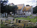
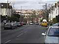
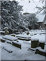
Living in BN1 6QP offers a distinct perspective on Brighton life within Preston Park Ward. This specific postcode covers a small residential cluster characterised by historical significance and modern convenience. The area forms part of a larger narrative where Preston Village, dating back to Saxon origins as Preste-tun, has been fully integrated into the city since 1873. Residents enjoy proximity to iconic landmarks such as Preston Manor, a building with thirteenth-century origins that now houses a museum and gardens. The historic Preston Park station, which opened in 1875, once connected this locality directly to London via the 1841 railway line. Today, the ward maintains a population of 1,639 people, creating a manageable community size despite its connection to the vibrant wider city. The area balances the quiet of a historic village setting with practical access to modern transport links, including Shoreham Brighton City Airport. For those seeking a home in a location with deep roots, BN1 6QP provides a residence situated near Brighton Park, the estate opened to the public in 1884 after a bequest of £70,000. The environment reflects a successful blend of heritage preservation and contemporary living.
- Area Type
- Postcode
- Area Size
- Not available
- Population
- Not available
- Population Density
- Not available
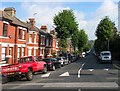
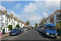
Buying a home in BN1 6QP requires an understanding of a market dominated by residential houses. The data indicates that 62 percent of residents own their homes, suggesting that the local property stock is heavily weighted toward owner-occupiers rather than private landlords. This high ownership rate typically implies that houses in the area are well-maintained by owners who have invested in their properties. Since the predominant accommodation type is houses, buyers looking for flats or apartments may find options limited within this specific small cluster, though the wider Preston Park area offers variety. The character of the housing likely reflects the architectural history of the ward, which includes listed buildings such as Preston Park House and structures with eighteenth-century facades. Purchasers here are often individuals seeking family homes or multi-bedroom properties suited to the median adult population. The market in this postcode is defined by the desire for space and privacy found in houses, distinguishing it from denser urban zones. Prospective buyers should note that the high ownership percentage may drive competition among those wishing to purchase, particularly families requiring the specific layout offered by these residential houses.
House Prices in BN1 6QP
No properties found in this postcode.
Energy Efficiency in BN1 6QP
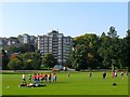
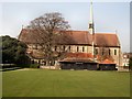
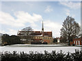
Daily life in BN1 6QP is facilitated by a cluster of amenities within easy reach. Five retail outlets serve the local population, including Supermarkets such as Sainsburys Brighton and the Tesco Hove Dyke and Tesco Hove branches. These grocery stores ensure that residents can meet their weekly shopping needs without excessive travel. Transport hubberies are also prominent, with access to five railway stations including London Road Railway Station and Hove Railway Station, effectively placing the borough on the Inter-city railway network. Leisure and nature are central to the lifestyle, highlighted by the historic Preston Park, which opened in 1884 and features the clock tower from 1892. The area also benefits from proximity to one airport, Shoreham Brighton City Airport, offering quick access to regional travel. Residents can walk to or drive past these five retail sites and railway stations as part of their routine. The presence of these amenities means that daily chores, social outings, and family trips require minimal travel time. The integration of historic parkland with modern supermarkets and stations creates a balanced environment. Whether visiting the shops at Tesco Hove or exploring the gardens near K-BIS Theatre School, the area offers a convenient mix of commerce and culture.
Amenities
Schools
Families considering BN1 6QP have specific educational options nearby, though the choice is limited within the immediate vicinity. The closest school listed is the K-BIS Theatre School, which operates as an independent institution. This type of school allows families to prioritise specialist training, such as drama and performance, rather than following the standard state curriculum. The presence of an independent school near the postcode suggests that residents value specialist education and are often willing to cover the associated fees. While state schools are not listed in the data for this specific cluster, the availability of K-BIS Theatre School provides a distinct and high-quality option for children with artistic interests. Parents may need to travel further for comprehensive state schools, but the independent choice offers an alternative pathway for academic development. The mix of school types in the broader Preston Park Ward would likely include state primary and secondary institutions, but the immediate data highlights only the independent provision. For those with children seeking theatre-focused education, living in BN1 6QP positions them close to a dedicated facility.
| Rank | School | Type | Entry gender | Ages |
|---|
Explore more schools in this area
Go to Schools tabDemographics
The community within BN1 6QP reflects a mature and established demographic profile. The median age of residents is 47 years, and the most common age range comprises adults between 30 and 64 years. This skew suggests a neighbourhood dominated by families and empty nesters rather than young professionals or students. Home ownership stands firm at 62 percent, indicating that the majority of households have purchased their properties and plan to stay. The primary accommodation type in this postcode is houses, which aligns with the higher rate of ownership compared to rental sectors. The predominant ethnic group is White, mirroring the broader traditional character of Brighton and Hove. These figures paint a picture of stability. With two-thirds of residents owning their homes, the area likely experiences less transient pressure than parts of the city centre. The age profile supports a environment where long-term community relationships are common. Families and couples form the bulk of the population, often seeking the stability that house ownership provides. This demographic mix creates a calm, settled atmosphere where neighbours generally know one another over multiple generations of homeownership.
Household Size
Accommodation Type
Tenure
Ethnic Group
Religion
Household Composition
Age
Household Deprivation
NS-SEC
Explore more demographic insights in this area
Go to Demographics tabPlanning
Planning Constraints
- Flood RiskPremium
- Ramsar Wetland SitesPremium
- Area of Outstanding Natural BeautyPremium
- Protected Nature ReservePremium
- Protected WoodlandPremium