Area Overview for BN1 4RA
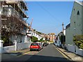
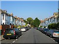
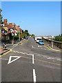
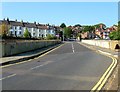
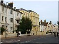
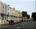
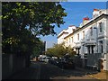
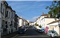
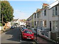
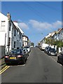
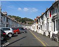
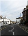
Photos of BN1 4RA
Area Information
BN1 4RA is a small, tightly knit residential area within the Preston Park Ward of Brighton & Hove, home to 1,810 residents. Historically rooted in Preston Village, which dates back to the Saxon era, the area blends heritage with modern living. Its proximity to Preston Park—a public space opened in 1883—offers residents easy access to greenery, historical landmarks like the Tile House and Preston Manor, and community events. The area’s compact size means amenities are within walking distance, while its integration into Brighton ensures access to city-wide opportunities. With a median age of 47 and a population skewed toward adults aged 30–64, BN1 4RA is a mature community, many of whom own their homes. The mix of historic architecture and contemporary infrastructure creates a distinct character, appealing to those seeking a balance between tradition and convenience.
- Area Type
- Postcode
- Area Size
- Not available
- Population
- 1810
- Population Density
- 7949 people/km²
The property market in BN1 4RA is characterised by a 58% home ownership rate, indicating a mix of owner-occupied homes and rental properties. The area is predominantly composed of houses, which are likely to be family-sized properties given the median age of residents and the presence of nearby schools. As a small postcode area, the housing stock is limited, making it a niche market for buyers seeking a specific location. The proximity to Preston Park and Brighton’s urban amenities may enhance property appeal, though the compact size of the area means buyers should consider nearby neighbourhoods for broader options. The predominance of houses suggests a focus on private, spacious living, which may be more attractive to families or those prioritising residential tranquillity over high-density housing.
House Prices in BN1 4RA
No properties found in this postcode.
Energy Efficiency in BN1 4RA
BN1 4RA offers a blend of practical amenities and historical charm. Nearby retail options include Sainsburys Brighton and Co-op stores at Ridgeland and Seven, ensuring daily shopping needs are met. The area’s proximity to Preston Park provides access to open green space, walking trails, and historical features like the Tile House and ha-ha wall. Residents can enjoy leisure activities in the park, which hosts events and community gatherings. The presence of rail stations within practical reach enhances connectivity, while the area’s integration into Brighton ensures access to cultural and dining options. This mix of local amenities and urban proximity creates a lifestyle that balances convenience with the appeal of a historic, green environment.
Amenities
Schools
The nearest school to BN1 4RA is Stanford Junior School, a primary institution with an Ofsted rating of ‘good’. This school serves the local community, providing education for younger children within the area. The absence of secondary schools in the immediate vicinity means families may need to consider commuting to nearby districts for secondary education. However, the presence of a well-rated primary school is a significant draw for families, as it reduces the need for long-distance travel for younger children. The school’s ‘good’ rating indicates a satisfactory standard of teaching and facilities, which can be a key factor for parents evaluating the area’s suitability for raising children.
| Rank | School | Type | Entry gender | Ages |
|---|
Explore more schools in this area
Go to Schools tabDemographics
BN1 4RA has a median age of 47, with the majority of residents falling within the 30–64 age range. This suggests a community of established professionals and families, many of whom are likely to have long-term ties to the area. Home ownership stands at 58%, indicating a stable housing market with a mix of owner-occupied properties and rentals. The predominant accommodation type is houses, which aligns with the area’s residential character. The predominant ethnic group is White, though specific data on diversity is not provided. The absence of detailed deprivation statistics means it is unclear how economic factors influence daily life, but the low crime risk score of 70 (on a 100-point scale) suggests a generally secure environment. This demographic profile points to a community that values stability, with a focus on family-oriented living and long-term residency.
Household Size
Accommodation Type
Tenure
Ethnic Group
Religion
Household Composition
Age
Household Deprivation
NS-SEC
Explore more demographic insights in this area
Go to Demographics tabPlanning
Planning Constraints
- Flood RiskPremium
- Ramsar Wetland SitesPremium
- Area of Outstanding Natural BeautyPremium
- Protected Nature ReservePremium
- Protected WoodlandPremium