Area Overview for BN1 4QE
Photos of BN1 4QE
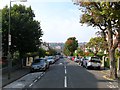
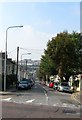
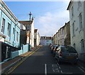
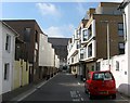


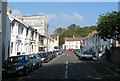
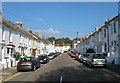
100 photos from this area
Area Information
Key information about the BN1 4QE including its size, population, and administrative classification.
- Area Type
- Postcode
- Area Size
- 6881 m²
- Population
- 2140
- Population Density
- 14708 people/km²
House Prices in BN1 4QE
78
Properties
£262,435
Average Sold Price
£29,250
Lowest Price
£600,000
Highest Price
Showing 78 properties
| Address | Type | Beds | Baths | Last Sale Price | Last Sale Date | |
|---|---|---|---|---|---|---|
| 37A Preston Road, Brighton, BN1 4QE | Flat | 1 | 1 | £265,000 | Aug 2025 | |
| 53A Preston Road, Brighton, BN1 4QE | Flat | 1 | 1 | £285,000 | Aug 2025 | |
| 31 Preston Road, Brighton, BN1 4QE | Flat | - | - | £312,400 | Sep 2023 | |
| 59C Preston Road, Brighton, BN1 4QE | Flat | 1 | 1 | £319,000 | Aug 2022 | |
| 33A Preston Road, Brighton, BN1 4QE | Flat | - | - | £275,000 | Jul 2021 | |
| 45A Preston Road, Brighton, BN1 4QE | Flat | 2 | 2 | £332,500 | Jun 2021 | |
| 71B Preston Road, Brighton, BN1 4QE | Maisonette | - | - | £270,000 | Aug 2019 | |
| 41 Preston Road, Brighton, BN1 4QE | Block of Flats | 7 | - | £600,000 | Aug 2018 | |
| 11A Preston Road, Brighton, BN1 4QE | Flat | - | - | £260,000 | Aug 2014 | |
| 13A Preston Road, Brighton, BN1 4QE | Flat | - | - | £222,000 | May 2008 |
Page 1 of 8
Energy Efficiency in BN1 4QE
Amenities
Schools
| Rank | School | Type | Entry gender | Ages |
|---|
Explore more schools in this area
Go to Schools tabDemographics
Household Size
Two person
most common
Accommodation Type
Flats
most common
Tenure
41
majority
Ethnic Group
White
most common
Religion
N/A
most common
Household Composition
N/A
most common
Age
47
median
Adults (30-64 years)
most common
Household Deprivation
N/A
with no deprivation
NS-SEC
40
in Lower managerial occupations
Explore more demographic insights in this area
Go to Demographics tabPlanning
Planning Constraints
- Flood RiskPremium
- Ramsar Wetland SitesPremium
- Area of Outstanding Natural BeautyPremium
- Protected Nature ReservePremium
- Protected WoodlandPremium