Area Overview for BN1 3ZZ
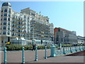
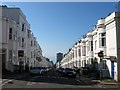
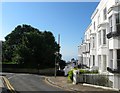
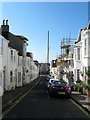
Photos of BN1 3ZZ
Area Information
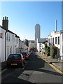
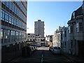
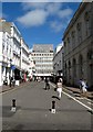
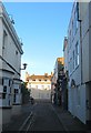
Living in BN1 3ZZ means settling into a specific postcode area that covers a small residential cluster within the historic electoral ward of West Hill and North Laine. This location is situated on the east-facing hill rising west from Brighton railway station towards Seven Dials and the bustling North Laine district to the north. The immediate vicinity holds a population of 1,846 people, creating a tightly knit community within a unitary authority established in South East England. This area represents a significant shift from its origins as an arable field surrounding medieval Brighton to its current status as a former industrial centre that now features boutique shops and compact terraces. You navigate an urban environment where the character is defined by its transformation from post-war decline to a protected historic district designated in 1977. Streets such as Church Street and Bond Street anchor the North Laine Conservation Area, offering a distinct bohemian atmosphere compared to more suburban locations. If you consider this area for your next move, you are entering a zone where history meets modern convenience, situated close to key arteries like the A259 and the A27. The combination of listed buildings, former market gardens, and sites like the 1957 Isetta factory New England Street creates a unique setting for daily life. The residential cluster benefits from its proximity to Brighton station, placing you immediately backed by a major transport hub while enjoying the relative tranquillity of the eastern hill slopes.
- Area Type
- Postcode
- Area Size
- Not available
- Population
- 1846
- Population Density
- 6396 people/km²
The property market in BN1 3ZZ is driven largely by rental demand rather than ownership, as only 35% of residents own their homes. This low ownership rate indicates that BN1 3ZZ functions as a dynamic rental hub within the wider Brighton and Hove unitary authority. The predominant accommodation type is flats, which fits the layout of the West Hill and North Laine ward where space is premium and historic terracing dominates the streetscape. Buyers looking at homes in BN1 3ZZ should expect to find compact units within conservation areas rather than spacious detached properties. Because the area is a small residential cluster, the property market moves quickly, often favouring tenants seeking a base in the heart of the action. The high density of flats means that if you are considering purchasing, you will likely be looking at leasehold properties with specific building regulations. The fact that three in five residents rent suggests a transient but steady population flow, where house prices often respond sharply to demand from those working in the nearby creative and service industries. There are no large housing estates here; instead, you find a mix of restored period properties and modern conversions. If you seek a primary residence, the flat ownership model offers flexibility for investors or professionals who do not wish to commit to building a long-term legacy in a historic district. The market remains sensitive to changes in the broader housing supply in the South East.
House Prices in BN1 3ZZ
No properties found in this postcode.
Energy Efficiency in BN1 3ZZ
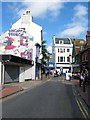
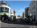
Your daily life in BN1 3ZZ is shaped by an urban environment centred on the historic North Laine Conservation Area. You will find five major retail outlets within practical reach, including Tesco Brighton, Sainsburys Brighton, and Budgens Brighton. These supermarkets provide essential convenience for your weekly shopping, meaning you can stock up on groceries without venturing far from the residential cluster. The area's character as a former industrial heartland now housing boutique shops and cafes means you have access to unique dining and leisure options alongside standard high street necessities. Accessibility is a key feature of living here, with five railway stations nearby, including London Road Railway Station, Hove Railway Station, and Preston Park Railway Station. You can reach these hubs quickly, facilitating easy commutes into central Brighton or further afield. The location on the hill rising towards Seven Dials offers views and quieter moments away from the centre, yet remains close to the action. Historically an arable field that became Brighton's industrial centre by 1931, the area now balances its past with modern amenities. You stroll along historic streets like Church Street and Gloucester Road, surrounded by listed buildings and compact terraces. The retail offerings and transport links ensure that your lifestyle combines the charm of a protected historic district with the practicalities of city living. Whether you prefer a quick coffee at a local haunt or a full meal at one of the many eateries, BN1 3ZZ delivers without requiring significant travel.
Amenities
Schools
For families relocating to BN1 3ZZ, the educational landscape is anchored by St Paul's CofE Primary School, which lies within practical reach of the area. This primary institution holds a Satisfactory Ofsted rating, indicating that it meets the required standards but may require continued development in specific areas. While there is no secondary school listed in the immediate vicinity of this postcode, St Paul's CofE Primary School serves the local children in this specific residential cluster. The presence of a single nearby primary school defines the educational experience for young residents in BN1 3ZZ. Parents relying on local education will need to consider transport links to secondary options outside the immediate BN1 3ZZ boundaries, as the provided data does not list nearby secondary institutions. If you have children of school age, your journey begins at St Paul's CofE Primary School, where the community fosters a cohesive local environment. The school's Situativity in the North Laine area means that pupils are immersed in the vibrant streetscape of the conservation zone. For those who prioritise proximity, this primary option offers a convenient start to schooling within the residential cluster. However, if you require a wider choice of secondary education, you will need to look beyond this specific postcode to the broader Brighton and Hove area. The current mix ensures that young families have access to at least one recognised local option before moving to high school alternatives.
| Rank | School | Type | Entry gender | Ages |
|---|
Explore more schools in this area
Go to Schools tabDemographics
The community in BN1 3ZZ is defined by a demographic profile where the majority of residents fall into the 30-64 years age range, making it a neighbourhood dominated by adults. The median age in this specific cluster sits at 47 years, indicating that most households likely contain established professionals or families rather than young people or retirees. With a population of 1,846, the area maintains a steady adult presence that shapes local shop hours and community activities around this specific age cohort. Accommodation in BN1 3ZZ is characterised primarily by flats, which reflects the density of a historic urban ward near the town centre. Only 35% of properties in this postcode area are owner-occupied, meaning that a significant portion of residents may be renting. The predominant ethnic group is White, which aligns with broader regional trends but reflects the specific historical development of the North Laine district. You do not find stately homes or detached villas here; the housing stock consists of compact units designed for the terrace style living that defines Brighton and Hove. This demographic and housing mix means the local amenities cater largely to tenants and dual-income households. For families moving here, the area feels like a stable, if dense, urban environment rather than a traditional family suburb with large gardens or detached houses.
Household Size
Accommodation Type
Tenure
Ethnic Group
Religion
Household Composition
Age
Household Deprivation
NS-SEC
Explore more demographic insights in this area
Go to Demographics tabPlanning
Planning Constraints
- Flood RiskPremium
- Ramsar Wetland SitesPremium
- Area of Outstanding Natural BeautyPremium
- Protected Nature ReservePremium
- Protected WoodlandPremium