Area Overview for BN1 3ZA
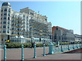
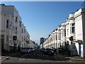
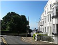
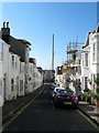
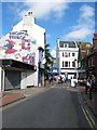
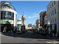
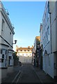
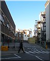
Photos of BN1 3ZA
Area Information
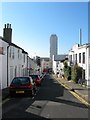
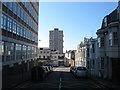
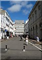
Living in BN1 3ZA means residing within West Hill and the North Laine district, a historic urban ward in Brighton and Hove. This specific postcode cluster covers a small residential area with a total size of 389 square metres, yet it supports a distinct community of 1,846 residents. The location sits at coordinates 50.826334, -0.140818, placing it on an east-facing hill that rises west from Brighton railway station. You are situated just steps away from the terminus of the main line, offering immediate access to the wider Sussex coast without needing a car for daily commutes. The North Laine transitioned from a post-war industrial and market garden landscape into a protected conservation area designated in 1977. Today, the street layout retains its historic character with leakways like Church Street and narrow terraces lining Gardner Street and Tichbourne Street. Your daily life here is defined by proximity to the town centre and a blend of boutique shops and historic sites. The area encompasses former workshops and sites like the 1957 Isetta factory location on New England Street, though modern development focuses on compact living. You find yourself in a neighbourhood where the past meets the present, characterised by listed buildings and a sense of history embedded in the architecture. Residents here benefit from being part of a compact cluster that feels both urban and connected. The setting offers a unique position close to commercial hubs while maintaining the narrative of an ancient arable field divided into furlongs since the late 18th century.
- Area Type
- Postcode
- Area Size
- 389 m²
- Population
- 1846
- Population Density
- 6396 people/km²
The property market within BN1 3ZA is characterized by a significant rental sector, with only 35 per cent of residents owning their homes. This statistic indicates that the area is primarily a rental market rather than an owner-occupied enclave. The accommodation type is exclusively flats, meaning you will find no detached houses or semi-detached bungalows in this specific postcode. This housing stock reflects the urban density of West Hill and the North Laine conservation area, where space is at a premium. If you are looking to buy homes in BN1 3ZA, the limited number of flats suggests competition may be fierce given the small total area of 389 square metres. Conversely, if you are a landlord or tenant, the high density of rental properties offers a stable environment with a mature demographic of adults aged 30 to 64 years. The presence of Listed Buildings and the designation as a Conservation Area since 1977 means that any development or renovation is strictly controlled by preservation guidelines. You should expect a market where original features are valued and structural changes are heavily regulated. The exclusivity of the flat layout means every square foot is utilized, catering to professionals who prefer city living over suburban sprawl.
House Prices in BN1 3ZA
Showing 12 properties
Energy Efficiency in BN1 3ZA
Your lifestyle in BN1 3ZA is enriched by immediate access to a variety of amenities within practical reach. For retail needs, you have a selection of 5 stores nearby, including Sainsburys Brighton, Tesco Brighton, and Budgens Brighton. These supermarkets allow you to handle weekly shopping without a long commute. The area also features a strong rail connectivity with 5 major stations in close vicinity, specifically London Road Railway Station, Hove Railway Station, and Preston Park Railway Station. This density of transport options gives you flexibility in how you commute to work or visit friends in Hove. The character of the neighbourhood is built on a history of market gardens and industrial workshops that have evolved into a bohemian district filled with boutique shops and cafes. You will find historic sites like the North Laine Conservation Area designated in 1977, which protects streets such as Cheapside and Gloucester Road. Living here means enjoying a vibrant atmosphere with a mix of historical significance and modern convenience. The proximity to Brighton railway station allows for quick escapes to the seafront or further afield. Whether you prefer a quick run to Tesco Brighton or a leisurely afternoon exploring the terraces of North Laine, the area supports diverse daily activities.
Amenities
Schools
For families considering schools near BN1 3ZA, the primary option nearby is St Paul's CofE Primary School. This institution holds an Ofsted rating of satisfactory, indicating that it meets the required standards for education and care. While the data does not list secondary schools or other primary institutions within this immediate proximity, St Paul's CofE Primary School serves as the identified local educational facility for this residential cluster. The availability of only one specific school in the provided data suggests that families in this postcode may rely on this primary school or transport students to facilities further away in the North Laine or Brighton centre. The satisfactory rating provides a baseline assurance of academic performance, though it does not signify excellence. You must conduct further research into travel times and catchment areas, as the data provided focuses solely on this specific parent single-entry point. The demographic profile of the area, with a median age of 47, suggests that while there are young children, the community spans a wide age range. Prospective buyers should verify if the school's catchment area aligns with your location on West Hill or North Laine before committing to a purchase.
| Rank | School | Type | Entry gender | Ages |
|---|
Explore more schools in this area
Go to Schools tabDemographics
The community residing in BN1 3ZA is defined by a mature age profile with a median age of 47 years. Most of the population consists of adults aged between 30 and 64 years, suggesting a neighbourhood populated by professionals or those nearing retirement rather than young families with small children. Home ownership stands at 35 per cent, meaning the majority of residents live specifically in rented accommodation. This contrasts with areas where purchase is the primary mode of residence, indicating a market where renting is the dominant form of tenure for the local populace. The composition of the housing stock consists exclusively of flats, which aligns with the high proportion of tenants and the urban density of the site. The predominant ethnic group in this area is White, reflecting the traditional demographic makeup of many historic Brighton wards. With a population density that places 1,846 people into a very small footprint, the living experience requires managing shared spaces and close quarters typical of flat living environments in city centres. The age distribution implies a community where career-focused individuals and those seeking stability without the responsibility of mortgages form the core demographic. You are entering a space where long-term tenancies are common, which brings stability to the street scene.
Household Size
Accommodation Type
Tenure
Ethnic Group
Religion
Household Composition
Age
Household Deprivation
NS-SEC
Explore more demographic insights in this area
Go to Demographics tabPlanning
Planning Constraints
- Flood RiskPremium
- Ramsar Wetland SitesPremium
- Area of Outstanding Natural BeautyPremium
- Protected Nature ReservePremium
- Protected WoodlandPremium