Area Overview for BN1 2JA
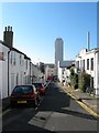
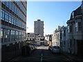
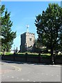
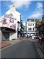
Photos of BN1 2JA


Area Information
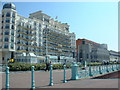
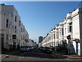
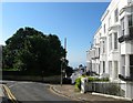
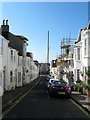
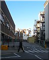
BN1 2JA lies at the heart of Brighton’s historic Regency Ward, a seafront district defined by its stucco-clad buildings, elegant squares, and proximity to the Royal Pavilion. With a population of 1,624, this small postcode area reflects Brighton’s legacy as a Regency-era resort town, where the Prince Regent’s influence shaped architecture and social life. The area’s defining feature is Regency Square, laid out in 1818, surrounded by well-maintained properties that blend historical charm with modern convenience. Daily life here is shaped by coastal proximity, with easy access to Brighton’s vibrant seafront, while the ward’s transient character suggests a mix of long-term residents and those drawn to the area’s heritage. Despite its compact size, BN1 2JA offers a blend of historic grandeur and practical amenities, making it appealing to those seeking a balance between tradition and accessibility.
- Area Type
- Postcode
- Area Size
- Not available
- Population
- Not available
- Population Density
- Not available
BN1 2JA is a rental-dominated area, with only 31% of homes owned by residents. The accommodation type is predominantly flats, which is typical for smaller, densely populated urban postcode areas. This suggests a housing stock tailored to single occupants or small households rather than larger families. The limited home ownership rate may indicate a reliance on private rentals or shared living arrangements. For buyers, this small area offers few owner-occupied properties, meaning opportunities are likely limited to nearby zones. The flat-dominated market may appeal to those seeking manageable, low-maintenance housing, though the lack of data on property prices or growth trends means the financial outlook remains unclear.
House Prices in BN1 2JA
No properties found in this postcode.
Energy Efficiency in BN1 2JA
Living in BN1 2JA offers access to a range of amenities within walking or short driving distance. Retail options include major chains like Sainsburys, Waitrose, and Tesco in Brighton, ensuring daily shopping needs are met. The area’s proximity to Brighton’s seafront and cultural landmarks, such as the Royal Pavilion, adds to its appeal. Rail connectivity is strong, with five stations providing links to London and other regional hubs. The nearby Shoreham Airport offers additional travel flexibility. While the area’s historic character dominates, its practical amenities ensure a balance between heritage and modern convenience, supporting both active lifestyles and easy access to urban amenities.
Amenities
Schools
| Rank | School | Type | Entry gender | Ages |
|---|
Explore more schools in this area
Go to Schools tabDemographics
BN1 2JA’s population of 1,624 is predominantly composed of adults aged 30–64, with a median age of 47. This suggests a community of professionals and families, though the 31% home ownership rate indicates a significant proportion of residents are renters. The area’s accommodation is largely flats, reflecting a focus on smaller, managed housing stock. The predominant ethnic group is White, though specific data on diversity beyond this is not provided. The low home ownership rate may imply a transient population, with residents more likely to move for work or lifestyle changes. The age profile suggests a mature demographic, potentially with established careers, though the absence of data on deprivation or income levels means the area’s economic challenges cannot be fully assessed.
Household Size
Accommodation Type
Tenure
Ethnic Group
Religion
Household Composition
Age
Household Deprivation
NS-SEC
Explore more demographic insights in this area
Go to Demographics tabPlanning
Planning Constraints
- Flood RiskPremium
- Ramsar Wetland SitesPremium
- Area of Outstanding Natural BeautyPremium
- Protected Nature ReservePremium
- Protected WoodlandPremium