Area Overview for BN1 1EQ
Photos of BN1 1EQ

Area Information
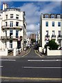
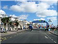
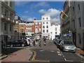
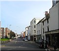
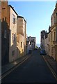
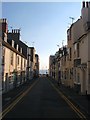
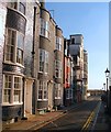
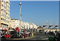
BN1 1EQ lies in the heart of Brighton’s central seafront district, a historically significant area shaped by the Regency era. This postcode covers a small residential cluster with a population of 1,783, characterised by its Regency-era architecture, including classical white stucco buildings and elegant squares. The area is defined by Regency Square, laid out in 1818, and proximity to the Royal Pavilion, a landmark commissioned by the Prince Regent. The ward’s transient nature reflects its appeal to those seeking a blend of historic charm and modern convenience. Daily life here is shaped by the seafront’s proximity, with easy access to coastal walks and cultural attractions. However, the area’s small size means it is densely populated, with limited space for expansion. Its location near Brighton’s core ensures a mix of historic and contemporary influences, though the high crime risk noted in assessments requires attention. For buyers, the area offers a unique window into Brighton’s Regency past, though its compact footprint means properties are closely spaced.
- Area Type
- Postcode
- Area Size
- Not available
- Population
- 1783
- Population Density
- 3976 people/km²
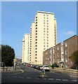
The property market in BN1 1EQ is characterised by a low home ownership rate of 19%, indicating that the majority of residents rent their homes. Flats are the primary accommodation type, reflecting the area’s compact footprint and historical development as a residential cluster. This suggests a limited housing stock, with properties likely concentrated in older, purpose-built blocks or converted buildings. The small size of the postcode area means buyers must consider nearby zones for more options, though proximity to Brighton’s central amenities may justify higher prices. The transient nature of the population, combined with the rental focus, implies a market driven by short-term demand rather than long-term investment. For buyers, this area may appeal to those seeking a historic setting, though competition for properties could be fierce given the limited supply.
House Prices in BN1 1EQ
No properties found in this postcode.
Energy Efficiency in BN1 1EQ
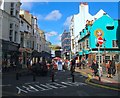
The lifestyle in BN1 1EQ is shaped by its proximity to retail and transport hubs. Five notable retail venues include Sainsburys Brighton, Morrisons Kemp, and Co-op Brighton, offering everyday shopping convenience. The five nearby railway stations—London Road, Hove, and Preston Park—provide easy access to Brighton’s cultural and commercial centres, as well as regional connections. While the area lacks detailed information on parks or leisure facilities, its historic seafront location likely offers coastal walks and nearby attractions. The combination of retail options and rail connectivity supports a practical, accessible lifestyle, though the small postcode size may limit the variety of amenities within immediate reach.
Amenities
Schools
The nearest school to BN1 1EQ is Middle Street Primary School, a primary school with a ‘good’ Ofsted rating. This single school serves the area’s young population, though the absence of secondary schools or further education institutions nearby may require families to travel to adjacent wards. The ‘good’ rating suggests a competent educational offering, but the lack of diversity in school types—only primary education is listed—means parents may need to look beyond BN1 1EQ for secondary schooling. This could be a consideration for families planning long-term stays, as it may affect the area’s appeal for those requiring a full range of educational facilities.
| Rank | School | Type | Entry gender | Ages |
|---|
Explore more schools in this area
Go to Schools tabDemographics
BN1 1EQ has a median age of 22, with the most common age range being 15–29 years. This indicates a young, transient population, likely drawn to the area’s historical and cultural assets. Only 19% of residents own their homes, with flats being the predominant accommodation type. This suggests a rental market dominated by short-term tenancies, reflecting the area’s appeal to students, professionals, or those seeking temporary housing. The predominant ethnic group is White, though the data does not specify further diversity metrics. The low home ownership rate and high proportion of young adults imply a community shaped by mobility rather than long-term settlement. For quality of life, this demographic profile may mean a dynamic but less stable social environment, with amenities and services tailored to younger residents.
Household Size
Accommodation Type
Tenure
Ethnic Group
Religion
Household Composition
Age
Household Deprivation
NS-SEC
Explore more demographic insights in this area
Go to Demographics tabPlanning
Planning Constraints
- Flood RiskPremium
- Ramsar Wetland SitesPremium
- Area of Outstanding Natural BeautyPremium
- Protected Nature ReservePremium
- Protected WoodlandPremium