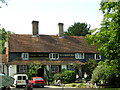
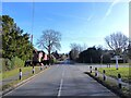
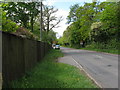
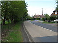
Area Overview for Blackboys
Photos of Blackboys


Area Information
Living in Blackboys offers a compact, built-up environment spanning 26.3 hectares, typical of a small town or city. The area’s population skews older, with a median age of 70, suggesting a community of long-term residents. Home ownership is high at 85%, indicating stability and a preference for settled living. Daily life here is likely characterised by a quiet, established rhythm, with local amenities and transport links shaping routines. The proximity to three railway stations—Buxted, Uckfield, and Crowborough—provides straightforward access to nearby towns, while nearby retail outlets like Tesco Uckfield and Co-op MRMF offer practical shopping options. Though small, Blackboys is functional, with its schools and transport networks serving residents efficiently. The area’s appeal lies in its simplicity: a place where convenience and familiarity coexist, catering to those seeking a low-maintenance, community-focused lifestyle.
- Area Type
- Built Up Area 250
- Area Size
- 26.3 hectares
- Population
- Not available
- Population Density
- Not available
Residents of Blackboys benefit from nearby amenities that support everyday living. The area is within reach of five retail outlets, including Budgens Isenhurst, Tesco Uckfield, and Co-op MRMF, providing essential shopping options. Three railway stations—Buxted, Uckfield, and Crowborough—offer easy access to public transport, enhancing mobility for work, leisure, or travel. While parks or leisure facilities are not detailed in the data, the presence of retail and transport hubs suggests a practical, community-focused lifestyle. The combination of local shopping and rail connectivity ensures that daily needs are met without the need to travel far, contributing to a convenient, low-stress environment.
Amenities
Schools
The primary school nearest to Blackboys is the Blackboys Church of England Primary School, which holds an Ofsted rating of ‘good’. This institution serves the area’s younger residents, offering a foundation for local children’s education. The absence of secondary schools in the data suggests that families may need to travel to nearby towns for further education. The presence of a single primary school with a solid rating indicates that basic educational needs are met, though parents seeking a broader range of school options may find the area’s offerings limited. For those prioritising a strong local school, the primary institution here provides a reliable starting point.
| Rank | School | Type | Entry gender | Ages |
|---|
Explore more schools in this area
Go to Schools tabDemographics
Blackboys has a median age of 70, reflecting a population that is predominantly older. The data shows 85% of homes are owner-occupied, a figure that underscores a community rooted in long-term residency rather than transient renters. Household composition and accommodation types are not specified, but the high home ownership rate suggests a mix of family homes and retirement properties. The predominant ethnic group and religious demographics are not detailed, but the area’s overall profile points to a stable, mature population. With no data on deprivation, it is reasonable to infer that the community’s needs are met by existing infrastructure, though this remains unverified. The age profile implies a focus on retirement living, with local services and amenities tailored to older residents.
Household Size
Accommodation Type
Tenure
Ethnic Group
Religion
Household Composition
Age
Household Deprivation
NS-SEC
Explore more demographic insights in this area
Go to Demographics tabPlanning
Planning Constraints
- Crime RiskPremium