Area Overview for BH25 6PE
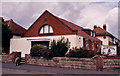
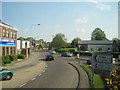
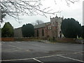
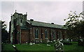
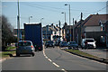
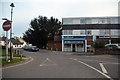
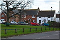
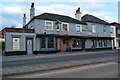
Photos of BH25 6PE


Area Information
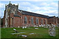
BH25 6PE is a small residential postcode in England, encompassing a tightly knit cluster of homes with a population of 1,329. The area’s high population density of 1,109 people per square kilometre suggests a compact, community-focused layout. Situated in a region with historical roots in the ancient village of Milton, the area blends traditional charm with modern practicality. Its proximity to coastal towns like Bournemouth and Christchurch offers easy access to seaside amenities, while its inland position near the New Forest provides a quieter, more rural feel. Daily life here is shaped by its small-scale nature—residents are likely to know their neighbours, with local shops, rail links, and ferry services within reach. The area’s character is defined by its mix of historic landmarks, such as the parish church of St Mary Magdalene, and practical infrastructure like New Milton Railway Station. For those seeking a balance between coastal living and inland convenience, BH25 6PE offers a distinct, manageable community where local traditions and modern needs coexist.
- Area Type
- Postcode
- Area Size
- Not available
- Population
- 1329
- Population Density
- 1109 people/km²
The property market in BH25 6PE is characterised by a high proportion of houses, which is atypical for a small postcode but aligns with the area’s historical development as a market town. With 48% of homes owner-occupied, the market is not dominated by rentals, though the remaining 52% may be available for let. This suggests a balance between long-term residents and those seeking temporary housing. The small size of the area means property choices are limited, and buyers should consider nearby towns like New Milton, which has a larger population and more varied housing stock. The predominance of houses may appeal to families seeking space, but the compact nature of BH25 6PE could limit availability for larger properties. Prospective buyers should also note the area’s proximity to transport links, which may influence property value and desirability.
House Prices in BH25 6PE
No properties found in this postcode.
Energy Efficiency in BH25 6PE
Living in BH25 6PE offers access to a range of amenities within practical reach. Retail options include Lidl, Tesco, and Morrisons, providing convenience for daily shopping. The area’s rail network, with stations like New Milton and Sway, connects residents to nearby towns and cities, while ferry services at Mudeford Quay and Hengistbury Head offer scenic coastal travel. Parks and recreational spaces, such as the War Memorial Recreation Ground, provide green spaces for leisure. The historic character of the area, including landmarks like the parish church and red brick water tower, adds cultural value. However, the small size of BH25 6PE means amenities are concentrated, requiring residents to venture slightly further for more specialised services. The blend of practical infrastructure and local heritage creates a lifestyle that balances convenience with a sense of community.
Amenities
Schools
The schools near BH25 6PE include The Arnewood School, which operates as both a primary school and an academy with an Ofsted rating of inadequate. The Eaglewood School is also listed but lacks a specified type. This mix of school types may present challenges for families seeking consistent educational standards, particularly given the academy’s rating. The presence of two schools suggests a local focus on education, but the inadequate rating at The Arnewood School could be a concern for parents prioritising high-quality schooling. Families may need to look beyond the immediate area for more options, though the proximity of New Milton, a larger town, could offer additional choices. The data does not clarify the performance of the Eaglewood School, so further research would be necessary to assess its suitability.
| Rank | School | Type | Entry gender | Ages |
|---|
Explore more schools in this area
Go to Schools tabDemographics
The community in BH25 6PE is predominantly composed of adults aged 30–64, with a median age of 47. This suggests a stable, middle-aged population, likely with established careers and families. Home ownership sits at 48%, indicating a mix of owner-occupied properties and rental units. The accommodation type is primarily houses, which is unusual for a small postcode but may reflect the area’s historical development patterns. The predominant ethnic group is White, with no specific data on other demographics provided. The age profile and home ownership rate suggest a community focused on long-term stability rather than transient populations. However, the lack of detailed diversity data means the full range of cultural and socioeconomic factors influencing quality of life remains unclear.
Household Size
Accommodation Type
Tenure
Ethnic Group
Religion
Household Composition
Age
Household Deprivation
NS-SEC
Explore more demographic insights in this area
Go to Demographics tabPlanning
Planning Constraints
- Flood RiskPremium
- Ramsar Wetland SitesPremium
- Area of Outstanding Natural BeautyPremium
- Protected Nature ReservePremium
- Protected WoodlandPremium