Area Overview for Bexhill Central Ward
Photos of Bexhill Central Ward
Area Information
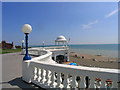
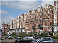
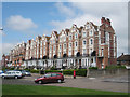
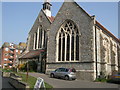
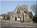
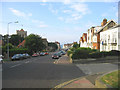
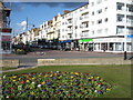
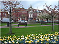
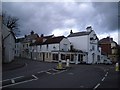
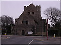
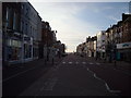
Living in Bexhill Central Ward means residing within a specific district council ward located in the seaside town of Bexhill. This area forms part of the Bexhill and Battle constituency and sits within Rother District, East Sussex, England. You will find the ward covers 97.8 hectares, offering a compact yet diverse environment. The town itself rises to approximately 46 metres above ordnance datum, perched on a hilltop at the edge of the High Weald. Your daily life involves navigating a landscape that combines the medieval Old Town with later resort developments established after 1880. The central resort area sits between the historic core and the seafront, creating a distinct residential character. The parish church of St Peter stands as a focal point within the historic core, while the town centre is strictly bounded by Sackville Road, Buckhurst Road, Sea Road, and the Seafront. Residents benefit from a built-up seafront extending roughly 6.2 km, with suburbs continuing inland about 3 km to the north of Sidley. Transport is facilitated by the A259, the main Hastings-Brighton road, which bypasses the Old Town via King Offa Way on its north side. The principal inland routes include the A269 leading to Ninfield, Battle, and the A21, or the A269 towards Herstmonceux, Hailsham, and the A22. This ward offers a blend of coastal proximity and access to broader road networks, defining the practicalities of living in Bexhill Central Ward.
- Area Type
- District Borough Unitary Ward
- Area Size
- 97.8 hectares
- Population
- Not available
- Population Density
- Not available
Demographics
The community in Bexhill Central Ward reflects a mature population with a median age of 70. This demographic profile indicates that the majority of residents fall into the older age bracket. You are likely to encounter an established community where stability outweighs rapid population turnover. Home ownership is significant, with 50% of households in the ward owning their properties. This statistic places the area in a balanced position between owner-occupiers and other tenure types, suggesting a mix of long-term residents and potentially some seasonal residents or investors. Household composition and predominant ethnic group data are not specified in the current records, meaning you cannot determine specific minority or family unit statistics for this ward. However, the high median age suggests a neighbourhood drawn to by retirees rather than young families or newly formed households. The area does not host Ramsar wetland sites, holds no Area of Outstanding Natural Beauty designation, and contains no protected nature reserves or protected woodland. These planning constraint scores indicate a lack of major environmental restrictions that might otherwise influence residential development or land use. Consequently, the demographic atmosphere is defined by the age of the populace rather than complex diversity metrics or protected natural assets within the ward boundaries.
Household Size
Accommodation Type
Tenure
Ethnic Group
Religion
Household Composition
Age
Household Deprivation
NS-SEC
Explore more demographic insights in this area
Go to Demographics tabPlanning
Planning Constraints
- Flood RiskPremium
- Ramsar Wetland SitesPremium
- Area of Outstanding Natural BeautyPremium
- Protected Nature ReservePremium
- Protected WoodlandPremium
- Crime RiskPremium