Area Overview for Asthall
Photos of Asthall
Area Information
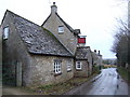
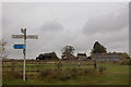
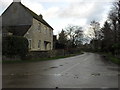
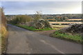
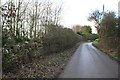
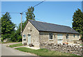
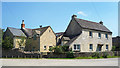
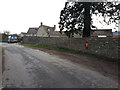
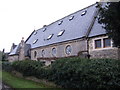
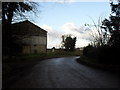
Living in Asthall offers a quintessential countryside escape deep within the Cotswolds. This civil parish spans an area of 9.0 km² and sits on the banks of the River Windrush, situated about six miles west of Witney and three to four miles east of Burford. The village occupies a position near the south-west end of Wychwood Forest and close to the Roman road Akeman Street. Residents enjoy a setting defined by picturesque lanes and natural beauty, creating a peaceful environment typical of the Windrush Valley. The community is rooted in history, with the area dating back to Roman times. Traces of a Roman settlement exist near the Church of St Nicholas, which predates 1160 and was later enlarged. Nearby Bronze Age and Saxon barrows further evidence the long human history of this location. Grade II listed Asthall Manor House stands as a notable landmark, a Jacobean property built around 1620 for Sir William Jones. The estate later became the home of the Mitford family between 1919 and 1926. This period inspired Nancy Mitford to write novels such as *Love in a Cold Climate* and *The Pursuit of Love*, adding significant cultural weight to the location. The parish holds an annual horse show, adding a traditional rural activity to the calendar. While Roman villa ruins at North Leigh and Minster Lovell Hall remain nearby, they serve primarily as historical context rather than immediate amenities. For those seeking a quiet life surrounded by ancient landscapes, Asthall provides a distinct atmosphere characterised by its proximity to these historic sites and its tranquil riverbank location.
- Area Type
- Parish
- Area Size
- 9.0 km²
- Population
- Not available
- Population Density
- Not available
Demographics
The community in Asthall is defined by an older demographic profile. The median age reaches 70 years, indicating that the population skews heavily towards retirees and established residents. This age structure suggests a neighbourhood where younger families are less common compared to other parts of Oxfordshire. House ownership stands at 74%, reflecting a settlement where long-term residents and owners predominate. This high figure aligns with the quiet, established nature of the village. Accommodation types and household composition data confirm a settled community pattern. The parish acts as a residential hub rather than a commuter town for young professionals. This ownership level and age distribution create a stable social fabric. Residents here likely prioritise stability and established schools over rapid lifestyle changes or transient living arrangements. The lower population density associated with a median age of 70 contributes to the widely spaced layout of homes. You will find that the neighbours are likely to be peers or those who have lived in the area for decades. This demographic reality shapes the local shops, services, and community events, which cater to older residents. The lack of significant youth migration into the area reinforces the peaceful character described in local histories. For a buyer, this means engaging with a community that values tradition and history. The 74% home ownership rate further proves that most people intend to stay in Asthall for the long term. This demographic consistency offers predictability for anyone considering moving to a retirement-friendly or tranquil environment.
Household Size
Accommodation Type
Tenure
Ethnic Group
Religion
Household Composition
Age
Household Deprivation
NS-SEC
Explore more demographic insights in this area
Go to Demographics tabPlanning
Planning Constraints
- Flood RiskPremium
- Ramsar Wetland SitesPremium
- Area of Outstanding Natural BeautyPremium
- Protected Nature ReservePremium
- Protected WoodlandPremium
- Crime RiskPremium